25 September 2015

Shaw Island

The Salish Sea, including Puget Sound, was carved by glaciers during past ice ages. When sea-level began rising about 10,000 years ago, it left a maze of channels and islands in central and northern Washington. The San Juan Islands are nestled between Vancouver Island to the west and mainland Washington to the east. There is regular ferry service to four of the islands – San Juan, Orcas, Shaw and Lopez – and of these, Shaw is the least populated and developed.

I arrived yesterday morning on Shaw and made my way to Indian Cove on the south side of the Island. This county park (where I also camped last night), is about the only official place to launch a boat since the vast majority of the island is privately owned. I paddled for about two hours around the east and northeast ends of Shaw to Blind Island, a tiny rock at the north end of Blind Bay and south side of Harney Channel.

Shaw Island in northern Washington state.

Blind Island is along a “marine trail” and boaters can pitch a tent there for a modest fee. The island is mostly grass and rock and weeds (unfortunately some non-natives like English Ivy are established there), but I found about 5 tree species including madrone, douglas fir, grand fir, and apples. It was a surprise to see apple trees; perhaps a resident of Shaw tried to establish an orchard here in the past.

The return paddle was another 2-3 hours and I explored the eastern shore of Canoe Island for a time. It was between Shaw and Canoe Islands that I saw the most developed bull kelp forests of the day. With a single unbranched stipe, these annual kelps reach the waters surface where their deep brown blades spread out to gather sunlight. Along my paddling route, I saw a variety of wildlife, though it wasn’t possible to capture all on camera – a bald eagle, many other birds, curious harbor seals, river otters (!) and a dolphin. 

Skittish river otters at the edge of the water southwest of Indian Cove. From my boat it was difficult to see these
otters under the dark overhanging rocks and trees, but with my telephoto lens this shot came out great!

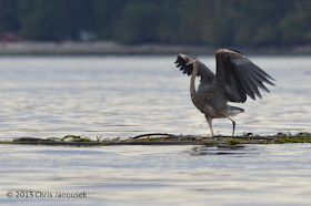
A great blue heron standing on a raft of bull kelps near Shaw.
Just after setting up camp yesterday evening back on the south shore of Shaw, the rains came and continued a bit into the morning. There was a so-so low tide early in the day, so I walked out to Reefnet Point on the south end of the Shaw to observe the intertidal. Only a few species of seaweeds were common, and of these, Fucus and Ulva comprised most of algal cover along the rocks. In the shallow and fairly murky water, however, I found a variety of interesting invertebrates: cancer and other crabs, shrimp, anemones and one or two species of holothuroideans (sea cucumbers).


With limited places to explore (so much of the island is private property), I’m not sure I’m likely to visit Shaw again in the near future, but being at the center of the archipelago, it is a good starting point for kayaking adventures to other islands in all directions. And, aside from the occasional noise of airplanes, ferries or other sources, the island was very quiet, a great location for solitude.

A madrone hanging over the water on the northwest shore of Shaw Island.


22 September 2015

Sauvie Island

It was a gorgeous weekend in the Pacific Northwest, the time of year when the warmth of late summer lingers but the first signs of fall appear: yellowing maple leaves, a sky full of cumulus clouds and a few raindrops. 

The Columbia River, third largest river in the US, is one of the iconic symbols of the Northwest. Yet despite living in Oregon for four years until recently, I’ve really spent little time exploring it. I had a free afternoon on Sunday, and a boat, and was in Portland, so off to explore the Columbia it was.

Seagulls over the Columbia River. Sauvie Island in Oregon is to the left; Washington State is to the right.

The northern end of Sauvie Island with approximate
 locations where jumping fish were observed. USGS Topo.
If the signs are to be believed, Sauvie Island is the largest riverine island in the nation (Oregon seems to have a penchant for pointing out superlative natural landmarks, an example being the ‘D River’ on the central coast, which is apparently the “nation’s shortest river” or something like that). Sauvie Island is located just northwest of where the Willamette River meets the Columbia, and it is large indeed: large expanses of farms and woodland protected by levees, and miles of roads throughout the island connected to the Oregon mainland by a single bridge. The northern part of the island is a state wildlife reserve. It was there that I launched the kayak on the western bank of the river.

The afternoon was calm and virtually all of the chop to contend with in the kayak was generated by the frequent passing of motorboats. I paddled perhaps a few miles north along the river, staying close to the shore, and finally rounded the tip of the island turning south into the Multnomah Channel. The island shoreline alternated between sand and firm mud; the upland was vegetated with deciduous trees, shrubs and some late season wildflowers.

A perched blue heron.


The highlight? Definitely fish jumps. I unexpectedly caught the first, a large salmon perhaps a hundred meters away that flopped a half meter into the air to crash back into the cool river. Over the next couple hours of rowing I saw (or heard) several more splashes, the fish leaping to catch an insect meal or tease the fisherman on the river. Their infrequent leaps and splashes lasted just a second, a real challenge for anyone trying to record the action. 
This is the most luck I had catching a shot of jumping fish. 


Algae and vascular plants at the shore of Sauvie Island. The sedge at right is so cool, but I have not yet tried to identify it.

13 September 2015

The west is ablaze

Much of the western United States has been on fire this summer. Affected landscapes range from California chaparral to temperate rainforest in the Pacific Northwest. Fire danger appears to be elevated this year because of the convergence of a few important factors. First, much of the western US (but particularly California) has been experiencing severe drought over the last few years. Second, climate change continues to steadily result in higher land temperatures year over year. And finally, western forests have been subject to a long history of fire suppression by management agencies that have left more fuel than would otherwise be present.

Fire is a natural part of some ecosystems. In fact, certain plant species are dependent on fire for establishment of juveniles or completion of their life cycle. Examples include many species of pines and the giant sequoia of the Sierra Nevada. The latter species requires high light and fires help clear out competitors that might shade young sequoias.

Stebbins Cold Canyon Reserve in spring 2014 with
pine, oak and chaparral habitat.
Unfortunately, fire management policies have exacerbated the threat of large intense fires in the west. During the early decades of the 1900s, fire was suppressed at all costs. In some cases this may have led to the excessive buildup of fuels in dense forests. Once the importance of fire to some native ecosystems began to be better understood, land management agencies such as the US Forest Service recognized the importance of allowing some fires to run their course. Despite this change in attitude about fires in western ecosystems, fires are still managed in many cases. Continued encroachment of human development deeper into forests or other wildlands increases the likelihood that a fire will need to be suppressed to protect human infrastructure instead of letting it runs its natural course.

The Wragg fire was a moderate sized fire that ignited earlier this summer and burned through chaparral and pine forest habitat along state route 128 in the coast range hills of northern California near Lake Berryessa. The fire consumed the whole area of the Stebbins Cold Canyon Reserve, a small University of California research reserve where I have been hiking several times over the last decade.

Stebbins Cold Canyon Reserve protects a north-south oriented canyon in the hills of the northern California coast range. It is an example of relatively dry coast range habitat, with a mixture of chaparral and oak and pine woodland. The valley floor has a small creek with riparian habitat and the valley slopes are spotted with oaks and pines and manzanitas.

My most recent hike at the reserve was during April 2014. Monkeyflowers, Brodiaea, Castilleja and Dichelostemma were in bloom at the time. The most striking plant I observed was the heartleaf milkweed, Asclepias cordifolia. Emerging stoutly a half meter or so from the short groundcover of grasses, it had slate green fleshy opposite leaves and bright purple flowers. The magenta petals were slightly reflexed (bent backwards) and contrasted vividly with white hoods that form little loops around the center of the flower.

Habit and flowers of Asclepias cordifolia, heartleaf milkweed, spring 2014.

Cold Canyon in late August 2015, after the Wragg fire.
The Wragg fire however, transformed the landscape dramatically this summer. Although the Reserve is currently closed to visitors, from the highway it is possible to see the scorched hillsides. The ground was blackened and trees stood like ruins on the hillside. Looking closely, I could see that not all vegetation was equally affected; many trees had at least some green in their canopies, suggesting tree damage, but not complete mortality. Of course, the soil retains a seed bank and perhaps individuals of some species escaped mortality if the fire moved quickly through an area. It will be very fascinating over the next few years to hike the trails again and observe how the ecosystem recovers.


References

- Eckenwalder JE. 2009. Conifers of the World. Timber Press, Portland.
- Forest History Society. U.S.Forest Service Fire Suppression.
- Harvey HT. 1978. The sequoias of Yosemite National Park. Yosemite Association, Yosemite National Park, CA, 36 pp.