Southwest of Arches in Utah is Canyonlands National Park, a part of the Colorado
Plateau centered on the meeting point of the Colorado
and Green Rivers Island
in the Sky”, one of several major sections of the park.
 |
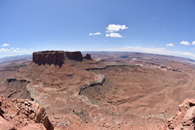
| Fisheye view of the canyon formed by the Green River. |
 |
| Candlestick Tower in the Green River Valley. |
At the southern tip of Island in the Sky, the meandering Colorado River flowing from the northeast meets the
meandering Green River flowing from the north.
A short trail leads out along the edge of the mesa presenting tremendous views
of the deep canyons in a panoramic view from the southeast to the west. The canyons
are immense in size and spectacular in their topographic variety.
From atop the mesa, the first
“level” of the canyons consists of a drop of over a thousand feet into wide
expansive valleys. From there, there are canyons that descend further until
finally one reaches deeper sinuous gorges. The rivers are so deep despite their
massive erosional footprint that they cannot be seen from the high mesas above.
On the Green
River side there are a few reddish flat-topped buttes that stand
out distinctly like crumbling Grecian buildings on the landscape. On the Colorado side, the
deeply lobed gorge is decorated with a scattering of white-topped columns that
reach up to the level of the upper basin. I think these would technically be
called “hoodoos”. All of these shapes and colors are mesmerizing and one feels
like soaring above to take it all in.
 |
| Junction Butte and the canyonlands around the confluence of the Green and Colorado Rivers. |
Reference
NPS. Canyonlands National Park map.
 |
| Columns within Monument Basin in the Colorado River canyon. |
 |
| Fisheye view of the Colorado River Canyon with Monument Basin at left. |
No comments:
Post a Comment