30 April 2017

Spring rain in the Painted Desert


Painted Forest, Petrified Forest National Park.
Unusual events leave lasting impressions on the mind, and my overnight trip to the Painted Desert of Petrified Forest National Park will definitely be one of them.

I arrived at the park on Monday afternoon after stops at El Malpais and El Morro National Monuments in western New Mexico. It was enjoyable seeing these sites, though I did not find them as interesting as Bandelier NM to the north. The wind was strong for much of the day on Monday and if anything, it increased as I drove through the remote town of Zuni Pueblo into eastern Arizona.

I obtained a backpacking permit from the Petrified Forest Visitor’s Center, intending to hike into the Painted Desert wilderness area north of the main park road and camp for the night. A trail leads into the wilderness from the old inn perched above the valley. I seemed to be the only one at the trailhead by evening, so I suspect I was the only visitor to the northern section of the park that night.

From the inn, the trail drops several hundred feet in elevation through brick red mud hills into a narrow wash that makes its way to the north. In this descent into the Painted Desert there were a surprisingly large number of plants in bloom, mainly of three species: bright red Castilleja (paintbrushes), yellow Calochortus (sego lilies), and purple Phacelia. A number of Yucca plants had flower spikes developing too, with a few flowers already open.

Flowers in bloom at Petrified Forest National Park. Left: Phacelia. Center: Ephedra. Right: Castilleja.

Calochortus before (left) and after (right) the rains.

I crossed Lithodendron Wash, a large dry creek bed which is perhaps some 20 m wide and which is a major hydrologic feature at the northern end of the park. The name is appropriate for the park: “litho” referring to rock, and “dendron” for tree. To the north beyond the dry wash, the wilderness begins. Large and small petrified wood was everywhere – in the wrinkles between the mud hills, in the alluvial fans at the base of the hills, and in the washes. The largest trunks were probably at least a half meter wide, but they were broken into segments that were not very long. One could imagine these Triassic conifers being a hundred feet tall or so when standing.

Trunk segments in a valley (left), and close-up of banding pattern in petrified wood (right).

Sunset was approaching after I entered the wilderness so I found a place to pitch the tent in a sort of cove of small mud hills with some nice petrified trunks strewn about for scenery in the morning. The wind was still strong at times even in this relatively protected area and the tent was a little difficult to set up. I left the rainfly off the top.

About 3:15 in the morning I awoke to the first sounds of raindrops on the tent. I hastily grabbed the rainfly and began to cover the tent. The rain grew harder, but the wind thankfully began to abate. I attempted to sleep more, but I awoke for good at dusk at about 5 AM. The rain continued, and if anything got harder as the early morning developed.

Peeking outside the tent in the early light of morning gave the first indication that the trek back to the car was possibly going to be an adventure. The hard desert crust on the north side of the tent was now soft mud. My finger sank easily into the mud. On the south side of the tent, a shallow rivulet was flowing, moving water off towards its eventual connection with Lithodendron Wash. My tent wasn’t even in a large drainage area. With what seemed like a lot of rain, how much water would be in the creek bed?

After about 5 hours the rain finally stopped. The center of my tent was still dry but most of the margins were wet and muddy. The rivulets of water remained near my campsite. I put the valuables like the laptop and camera in bags to keep them dry (should the rain return), and packed up my gear inside the tent as much as possible before attempting to deal with the mud.

Although the tent was pretty muddy, (and my hiking boots would eventually be muddy too), I managed to keep the rest of my gear fairly clean. I stepped into the gooey mud and noticed that the first inch of clay easily attached to my boots revealing the dry soil just below. A lot of water over a sustained period would be needed to deeply soak into this parched landscape. The landscape wasn’t a deep layer of mud like I’m used to in my coastal wetland work, but it was a thin layer of sticky goo all over the place.

The hike out of the wilderness and back to the inn was actually not that bad. By staying on the sandier bottoms of the washes, or by walking on rocks or gravel when possible, I could minimize the impact of my footprints on the desert clay and make my own trek through the desert easier.

Tent site (left) and traces of my footsteps (right). 

The rain had stopped, but down the narrow washes water flowed as pink rivulets, briefly redistributing some of the surface paint of the desert. Lithodendron Wash itself had flowing water or standing pools, but there was much less water than I expected. Perhaps the sound of the rain on the tent exaggerated the amount of rain that had fell that early morning, or more likely, the significant amount of rain that had fallen was easily absorbed by the surface clay in this large basin.

Pink rivulets of water in a small wash (left) and in Lithodendron Wash (right).

The desert plants, were they capable of emotions or the expression thereof, were probably rejoicing. Rain comes infrequently to the desert, and those brief periods of precipitation are like opening a well-stocked pantry after nearly starving for months. Drops of water lingered on leaves and flowers. Soils that had been cracked in the sun still retained the patchwork pattern of parched ground, but were now softened by the absorbed water.

I think I was fortunate to be in the desert during what seemed like a pretty significant rain storm. April is typically one of the drier months in the park. Surely there have been and will be larger storms, episodic events that bring enough water abruptly to collapse river banks and significantly erode channels. There was no thunder and lightening with this particular storm, elements that would have made the experience more adventurous but which would have also been a little dangerous. 

Painted Desert after the rains.


Yucca plants in the Painted Desert. 

Interesting rocky pavement in a small wash.

26 April 2017

Bandelier National Monument

Bandelier is a small gem located in the mountains northwest of Santa Fe in northern New Mexico. It is close to Los Alamos National Labs and the Valle Caldera. The park preserves both archaeological features of the Ancestral Pueblo people (much like Mesa Verde), and a mountainous landscape of forest and high desert savannah.

Cave dwellings at Bandelier. A few are open to visitors via ladders. Ar right: view from a cave dwelling with the ruins of a settlement in Frijoles Valley visible below the forest.

Starting at the visitors center, I took the main trail to see the ruins of the village and the cave dwellings that the former inhabitants carved into the soft sandstone rocks that line the northeast side of Frijoles Valley. Unlike Mesa Verde, visitors to the park are allowed to enter some of the dwellings without special tickets. I climbed into a few of the tight chambers with their natural rock windows and blackened ceilings from ancient fires. The people who used to inhabit Bandelier also used stone bricks and mortar to build living structures and kivas (ceremonial chambers) adjacent to the cliffs or on the valley floor.

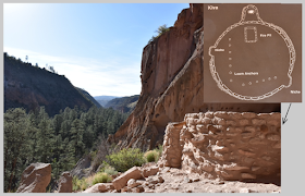
View of Frijoles Valley from a sandstone alcove where the ruins of a ceremonial Kiva were located. Inset at right is a NPS diagram of the layout of the kiva.

Box elder with developing fruits.
I continued hiking up Frijoles Canyon beyond the archaeological attractions into the Bandelier Wilderness. Frijoles Creek, a very narrow creek, ran with cool water. The valley from the visitors center up into the wilderness was well forested, mainly by ponderosa pine (Pinus ponderosa; needles in bunches of three) and box elder, a broadleaf tree that produces winged samara fruits like maples. There were other tree species too including gambel oak (their lobed leaves  are shaped like the valley oaks that I am used to in California), Douglas fir, narrow-leaf cottonwood, and maybe species of Salix and Tamarix

The valley had a number of blooming species of plants too including a lovely shrub (western chokecherry, Prunus virginiana). Each plant had numerous inflorescences several inches long with dozens of fragrant white flowers. Another very attractive species growing in forest areas was a member of the pea family (golden pea, Thermopsis rhombifolia), having spikes of yellow-flowers (suggesting a species of lupine), but leaves with three main leaflets (unlike other lupines that I am familiar with where there are typically many leaflets). In the more open grasslands, an attractive aster, with golden and red ray flowers could be found.


Reference

Blackwell LR. 2006. Great Basin Wildflowers. The Globe Perquot Press, Guilford, CN

The very fragrant and beautiful flowers of Prunus virginiana.
Frijoles Creek.

Left: Ruins of a village built at the base of the cliff wall. The parallel series of holes in the sandstone cliff are where wooden beams used to extend over the buildings. Right: Natural sandstone sculpture and valley ruins.

24 April 2017

Mesa Verde

Mesa Verde National Park preserves the pit dwellings, cliff houses, petroglyphs, and other structures of the Ancestral Pueblo people who inhabited the area from about 600 CE to 1300 CE. From the northern entrance to the park in southwestern Colorado, one ascends towards the highest point of the park and then gradually descends traveling southward into one of several valleys where the Ancestral Pueblo lived.

Spruce House. This area has been closed due to the hazards of rock falls. Here the Ancestral Pueblo built a village in a well-sheltered alcove in the sandstone cliffs. 

Spruce canyon with Yucca baccata in the foreground.
The park was different from my expectations prior to the visit, mainly in terms of vegetation and topography. I had pictured cliff dwellings set in steep mountains covered with green forests and lingering snow at this time of year. Rather, the mesa environment was fairly dry with more sparse vegetation and just a bit of snow in places. The snow-covered peaks of Colorado and eastern Utah could be seen in the distance, however.

A one mile hike from Spruce Tree House takes one to a small collection of petroglyphs carved into the vertical face of light-colored sandstone rock. The trail also affords pretty remarkable views of the canyons that cut the mesa at the south end of the park.

The cliff houses were the most interesting feature of the park in my view. These structures were made of sandstone blocks with mortar, and set in the vertical faces or alcoves of sandstone cliffs. One tower was 4-storied. Some of the dwelling locations seemed pretty inaccessible from either the top of the mesa or the valleys below. These areas possibly afforded protection from the elements or from hostile neighbors. The dwellings were apparently abandoned by the population of the area abruptly about 700 years ago but the cause isn’t well understood. 

Square Tower House.


Reference

Patraw PM. 1977. Flowers of the Southwest mesas. Southwest Parks and Monuments Association, Globe, AZ.

Sunset over eastern Utah.
Sunset from "Geologic Outlook".

23 April 2017

A grand view at Canyonlands

Southwest of Arches in Utah is Canyonlands National Park, a part of the Colorado Plateau centered on the meeting point of the Colorado and Green Rivers. The landscape of this area is dominated by the deep valleys forged over eons of time by the rivers. I spent only a few hours in the park, exploring a small part of “Island in the Sky”, one of several major sections of the park.

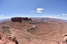
Fisheye view of the canyon formed by the Green River.

Candlestick Tower in the Green River Valley.
At the southern tip of Island in the Sky, the meandering Colorado River flowing from the northeast meets the meandering Green River flowing from the north. A short trail leads out along the edge of the mesa presenting tremendous views of the deep canyons in a panoramic view from the southeast to the west. The canyons are immense in size and spectacular in their topographic variety.

From atop the mesa, the first “level” of the canyons consists of a drop of over a thousand feet into wide expansive valleys. From there, there are canyons that descend further until finally one reaches deeper sinuous gorges. The rivers are so deep despite their massive erosional footprint that they cannot be seen from the high mesas above.

On the Green River side there are a few reddish flat-topped buttes that stand out distinctly like crumbling Grecian buildings on the landscape. On the Colorado side, the deeply lobed gorge is decorated with a scattering of white-topped columns that reach up to the level of the upper basin. I think these would technically be called “hoodoos”. All of these shapes and colors are mesmerizing and one feels like soaring above to take it all in.

Junction Butte and the canyonlands around the confluence of the Green and Colorado Rivers.


Reference

NPS. Canyonlands National Park map.

Columns within Monument Basin in the Colorado
River canyon.
Fisheye view of the Colorado River Canyon with Monument Basin at left.

22 April 2017

The living world of Arches

Small Gambel Oak (Quercus gambelii) at right with Yucca (lower left).
Cliffrose (Cowania mexicana), a shrub, at left in bloom and the showy Oenothera cespitosa at right. The large flowers lie close to the ground with relatively small foliage beneath.
Vibrant magenta flowers of hedgehog cactus, Echinocereus ?malanacanthus.
I only observed one blooming plant in the park at an overlook to Delicate Arch.
Paintbrushes did not seem to be particularly common. These flowers were seen
in the Devil's Garden.
Ephedra is a common plant in the park. The photo at right shows a close up of male flowers.
An identified pea (Fabaceae) in the Fiery Furnace. I believe I only saw
about two of these plants.
A complex biological soil crust at the Fiery Furnace. These crusts consist of
various microorganisms including cyanobacteria and take a long time to
form. Due to their ecological importance, the Park Service is concerned
about their damage. I saw well-developed crusts like this one in the Fiery Furnace
where access is more limited.
Lichens on the sandstone that makes up the side of Broken Arch.
Lizards were common in the park and usually allowed one to get relatively close
for a photograph. Unfortunately I did not see a leopard lizard which I think have
very a striking pattern of spots.
One of my favorite discoveries was finding animal tracks. These two sets of tracks were in soft sand near Sans Dune Arch. 
Two more sets of tracks from the Fiery Furnace. The ones at left are from a bird, while I'd like to image those at right are from a cat?
Pinyon, Pinus edulis. Along with junipers these are the largest
woody plants in Arches.
Yucca angustissima at the Devil's Garden. Two flower spikes
are developing. 
References

Blackwell LR. 2006. Great Basin Wildflowers. The Globe Perquot Press, Guilford, CN

Little EL. 1979. Forest trees of the United States and Canada, and how to identify them. Dover Publications Inc., New York

Patraw PM. 1977. Flowers of the southwest mesas. 6th ed. Southwest Parks and Monuments Association, Globe, AZ


20 April 2017

Ancient Arches

Landscape Arch (over 300 ft long!) in the Devil's
Garden region of the park.
At Arches National Park, one can’t help but be preoccupied with geology (even if you’re a biologist). The blooming Ephedra, desert lizards sunning themselves, and twisted Juniper are impressive, but for a first time visitor to Arches like me, it is the sheer scale of rock and erosion that first hits the senses (more on the biota later).

Arches is near the heart of the Colorado plateau, a region roughly centered on the four corners of the US. Across the area, rivers like the Colorado and Green cut deeply into the ancient rock, eroding meandering canyons. Water is responsible in part for the formation of rock arches too. The process begins with cracks that form in a solid block of sandstone (a type of rock called Entrada sandstone is particularly conducive to arch formation). These cracks form in parallel bands. Water erodes along these cracks, eventually creating a series of parallel ridges of rocks known as fins. The final step in arch formation occurs when water (with a mild acid) pools above a denser layer of rock within an individual fin and slowly dissolves a cavity in the sandstone by loosening the matrix holding the sandstone particles together.

Two views of "Double O" Arch, also in the Devil's Garden region.

A sandstone spire in the foreground with the La Sal
Mountains in the background. I really liked the
juxtaposition of erosion-dominated sandstone with
the (probably) more recently uplifted mountains.
In addition to the arches for which the park is famous, the rust-colored sandstone takes on a variety of shapes, from sheer rock walls to spires. Flat-topped mesas, like ancient ruins crumbling over eons are present too, both inside and outside Arches. These formations were among my favorite, perhaps in part because the buttresses of rubble around their bases emphasized the process of decay and suggested their great age.

During the last two days in eastern Utah, the forces of erosion dominate in this region in my mind, manifest in every major shape on the landscape. Erosion is everywhere, whether orderly like grooves in the soft earth or chaotic like a jumble of boulders that remain from a cataclysmic collapse of a rock formation.

References

Arches National Park Visitors Guide, published by Canyonlands Natural History Association, and National Park Service interpretive signs.

Morris TH, Ritter SM, Laycock DP. 2012. Geology Unfolded. An Illustrated Guide to the Geology of Utah’s National Parks. BYU Press.


Sandstone fins (left) and decorative features in sandstone (right).
This region of the park is known as the Courthouse Towers and was one of my favorite areas.
Another view of sandstone formationa and the La Sal
Mountains in the background.
This is Delicate Arch, the iconic arch of the National Park.
I wonder how this precariously perched rock (top center)
got in that position. Earthquake? Slow action of
(frozen) water?

18 April 2017

The Great Basin

The Great Basin region of the United States is a series of alternating mountain ranges and wide valleys stretching across Nevada and western Utah. The mountain ranges run north to south, breaking up the monotony of the Nevada landscape. The alternating mountain ranges and valleys formed through a process of faulting and stretching of the crust.

I confess to seldom thinking of Nevada as a place to explore as a naturalist. It has long seemed a place to just pass through while en route to more interesting destinations. However, in my first trip across central Nevada from the Sierra near the Tahoe region to Great Basin National Park in the western reaches of the state, I was stuck by the unexpected beauty of the landscape.

Heading west to east, the parallel ranges of mountains seem to have become increasingly attractive. The Toiyabe and Egan ranges in central Nevada in particular were notable. Most of the ranges are still wearing crowns of snow which add some vibrancy to the earthen tones of the landscape. Junipers became more frequent towards the eastern part of the state, forming pygmy forests at higher elevations.
Sand Mountain (left) and the Egan Range (right).

Traversing Nevada, I stopped only briefly at places, to photograph the mountains and look at weathered petroglyphs off the highway. US route 50, which winds through the basins and ranges is proudly advertised as “the loneliest road in America”.

Approaching the eastern edge of Nevada, the bright white Wheeler Peak came into view from the previous range to the west. At over 13,000 ft elevation, it forms the centerpiece of Great Basin National Park, an oasis of forest and snow. The main entrance to the park is on the eastern side, nearly in Utah. There, Lehman Creek runs off Wheeler Peak towards the lowlands.

Great Basin National Park, as viewed from near Sacramento Pass.

 Yesterday evening I hiked along part of the trail that follows the creek up the slopes of the mountains. There, at about 8000’, was a fairly dense forest that reminded me superficially of the forested Cascades, though the main conifer species differed. Single leaf pinyon pines (Pinus monophylla) was the dominant species, joined by at least two other conifers: Rocky Mountain fir, and Engelmann’s spruce. The most attractive trees to me were not the conifers, but white-barked hardwoods, still leafless, which I think are probably quaking aspens (Populus tremuloides). Their white or grey trunks (sometimes taking on greenish or orange hues), stood like skeletons, waiting to be clothed again with new leaves for another growing season.

Populus trees at about 8000 ft elevation near Lehman Creek.

According to the Park Service ranger, this is the most
iconic feature of Lehman Caves and is known as the
"parachute". It combines several types of formations
including "shields" (at top), "drapery", and "columns".
This morning I availed myself of perhaps the main attraction of the park, Lehman Caves. Following a guide for an hour and a half, our group walked through narrow passageways and larger chambers, observing thousands of limestone sculptures, each slowly built over hundreds or thousands of years and each unique. There is an entire geologic vocabulary for the major shapes formed by the precipitates, names which include columns, drapery, soda straws, shields, and popcorn. In the array of formations, Lehman Cave was much like the Oregon Caves that I visited last summer.

After the undulation of the Great Basin, I am off to the Colorado Plateau.

References

Kauffman ME. 2013. Conifers of the Pacific Slope. Backcountry Press, Kneeland, CA.

Little EL. 1979. Forest trees of the United States and Canada, and how to identify them. Dover Publications Inc., New York


"Soda straws" on the ceiling of the cave. All stalagtites start their existence as soda straws.
More "drapery" from the cave.
Single leaf pinyon. Along with juniper, this species
was very common in Great Basin National Park.