20 December 2015

Notes on some sea urchins of Hawaii

Map of the Big Island with intertidal and subtidal sites I
visited this fall. Map modified from this source.
Sea urchins were one of the prominent groups of marine invertebrates I encountered while exploring the intertidal and shallow subtidal of the Big Island’s coastline. Click here for a checklist of species published by the Bishop Museum. Some notes on a few common species:

1. The slate pencil urchin, Heterocentrotus mamillatus. This was the most striking of the species I found on the Big Island. Thick brick-red spines emerge from the body which is whitish or deep red. This species was present in both the low intertidal and the subtidal, including in coral reefs where it was often found in crevices. I was common along the Kona side of the Big Island.


Heterocentrotus mamillatus. Left: low intertidal urchin from Miloli'i. Right: subtidal animal at Old Kona Airport.

2.  Echinometra mathaei. This species was the most abundant overall in my coastal visits, commonly occurring in both intertidal pools and on subtidal reefs in high densities. The test diameter and spine length are both on the order of a few cm. Body color varied from a pale green to pink color. This species reminded me of Strongylocentrotus purpuratus, the common purple urchin of coastal California waters, in terms of size and morphology, and by its tendency to hide in small holes in the rocky substrate, perhaps sheltering there from predators.

Echinometra mathaei. Left: At Miloli'i; right: at Wai'opae.
The collector urchin, at Puako Bay.

3. The collector urchin, Tripneustes gratilla. Typically a subtidal species, it is purple to black overall, but often has at least some whitish and reddish spines. This species was common at Puako Bay where living coral cover appeared sparse, but there was significant cover of encrusting red coralline algae. It was also present at Honaunau Bay, Keauhou, and the Old Kona Airport on the Kona side of the island. The collector urchin is distributed in tropical waters of the Pacific and Indian Oceans.


4. The helmet urchin, Colobocentrotus atratus. This is a common intertidal species, usually black in color. Most of the spines on the body have been reduced to armor-like plates, while those near the sides are elongated to form a skirt around the animal. This species appears to favor more wave-swept coastlines and the overall shape probably minimizes hydrologic drag on the body. This species is probably a major intertidal herbivore, suggested by the barrens of pink corraline algae I often found in the vicinity of the animals. I observed this species at Ka Lae, Miloli’i, the Old Kona Airport, and Waikui Beach in the south Kohala District.

Colobocentrotus atratus. Both photos are from the intertidal at Keauhou, south of Kona.

5. Echinothrix calamaris, the banded urchin. This is a larger black urchin with menacing spines, occurring as either an all-black morph, or with white and black-banded spines. From my observations, the black morph was much more common on the Big Island. I found this species from intertidal tidepools to the subtidal. It was common at Waikui Beach and the shoreline near the Old Kona Airport. Also present at Honaunau Bay.

Two color morphs of Echinothrix calamaris. Left: subtidal at Honaunau Bay; right: subtidal at Waikui beach.
 
Close-up of Echinometra mathaei, with tube feet visible among the spines (white arrows).

Subtidal slate pencil urchins in coral at Waikui beach.
Reference

Stender K, Yuko K. 2014. MarinelifePhotography.com.

06 December 2015

The northern Hawaiian coast

Geographic regions of the Big Island. Map source
The northwestern district of Kohala and the Hamakua coast were among the final regions we visited while making a loop around the Big Island. Like Kau to the south, these areas less populated than the Kona and Hilo coasts, scattered only with small towns, farms, and impressive vistas of open space. There are a series of green valleys sculpted into the northeast-facing coast of Hamakua, largely inaccessible except by hiking.

From the North Kohala side, at the terminus of state road 270, is Pololu Valley. It appeared to have an estuary of sorts, with a sediment-laden chocolate stream that wound back into the valley. The mouth of the stream had a shallow connection to the ocean because of the buildup of large cobbles on the beach. Visible to the east were cliffs and a few offshore islets. The wind was strong here, stirring up numerous white caps out at sea. To me, the whole scene was reminiscent of portions of central California in some degree, like the rough coastal gem of the Big Sur area. 

The northwest coast of Hamakua from the overlook
above Waipio Valley. A waterfall nearly reaches
the beach.
Waipio Valley is also among this chain of coastal valleys. The valley used to be a prosperous settlement, both during Polynesian rule of the Hawaiian Islands and more recently. Hawaiians referred to it as the ‘Valley of the Kings’ (Barth 1995). A devastating tsunami in 1946 obliterated the area, and resettlement has been sparse. From Waipio Valley, there is a trail that heads northwest to the next coastal valley (Waimanu Valley) which would be a treat to backpack some day.

Down in Pololu Valley, the shore was rough with wind, waves, and a beach covered in cobbles of lava rock worn smooth by the surf. There also was a significant amount of debris – bottles, fishing buoys, decaying buckets. These items may have traveled thousands of miles to land on the shores of Hawaii. With some help from the kids, we gathered up a number of items to remove them from the beach.

Pollution is a distinctly visible reminder of humankind’s impact to our most cherished natural areas. It is particularly unwelcome on our beautiful coastlines. Yet, visibility aside, it is probably one of the lesser human impacts to the oceans. Habitat destruction, overfishing (which disrupts entire food webs), and changing climate are perhaps more pernicious threats to ocean biodiversity and function.


Pololu Valley.
A black cobble beach at Pololu Valley and the cliffs of the Hamakua coast in the distance.

Flying for hours over the vast Pacific, the immensity of the global ocean is made apparent. Individually, we are barely specks on this immense globe, so it is perhaps natural to assume that our species can have little impact on this globe. Yet evidence from every line of science points otherwise. When tsumani debris bearing living organisms arrives on the shores of Oregon from Japan (as I was able to observe firsthand a few years ago), it becomes apparent just how close supposed distant places are to each other. Our collective human impacts on our planet have become pervasive.

The kids helped gather marine debris washed ashore at Pololu Valley.

Coastal topography near Pololu Valley, from 1995 USGS topographic map, Honokane, HI.
Reference

Barth S. 1995. The Smithsonian Guides to Natural America. The Pacific. Smithsonian Books, Washington D.C.

01 December 2015

Wai'opae pools

Wai'opae pools among basalt bedrock and boulders.
The Big Island has about 6 Marine Life Conservation Districts, marine reserves established by the state of Hawaii that variously protect coastal marine organisms from harvest. A short stretch of coastline containing the Wai’opae pools is the only MLCD on the eastern end of the island. The site is southeast of Hilo, near the town of Kapoho, tucked behind a few coastal residences.

At Wai’opae the dark lava is spread in a wide flat bench that creates a broad area of pools between emergent rocks. Some of the pools are shallow and might be properly considered “tide pools”, but others are deeper and create permanent subtidal habitat. Partly isolated from each other, each pool is a small reef ecosystem.

Purple ember parrotfish, Scarus rubroviolaceus followed by an endemic saddle wrasse, Thalassoma duperrey among convict tangs.

Closeup of coral polyps.
 Saturday I spent several hours exploring five pools, ranging in size, depth and species composition. My son Ben located the first, a deep pool with a few corals and a moderate number of fish located far inshore from the breaking waves off shore.

Later I spent a little time in a round pool not wider than 5 or so few meters across, with black basalt enclosing a cozy aquarium. One side of the pool was shallow, the other deep, but each with a number of brown plate corals. The colonies of this species form rounded shelves against the rocks like shelf fungi that grow on trees or fallen logs in a temperate forest.

The last pool I explored was the largest and had the most obvious active connection to the ocean, indicated by a strong current present at the southeastern end. I was already cold at this point in the afternoon, but I probably ended up staying another hour in this pool. The axis of the pool was like a shallow V-shaped valley, along which I swam back and forth several times. Fish abundance in the pool was remarkable, and included wrasses, butterflyfish, large purple and greenish parrotfish, and a dense school of striped convict fish accompanied by several large black colored fish that swam with their smaller associates. Blue needle fish were common in the surface water, creating a ring around me, but keeping some distance.

Unidentified blenny perched in coral in a shallow pool.

The pools I observed did not have continuous coral cover. In fact, at some had just a few percent cover. Rather, corals appeared as discreet colonies, with bedrock, volcanic rubble, or fuzzy algal turfs occupying the rest of the space. They seemed absent from the shallowest areas, perhaps because these are exposed a low tides. Lobe (Porites sp.), lace, and plate corals were common. In the pools I found few species of larger macroalgae, but notable exceptions were a single siphonous green alga (?Caulerpa sp.) shaped not unlike an immature bunch of green grapes, and dichotomously branched thin blades of an attractive red foliose alga. Larger invertebrates included beautiful slate pencil urchins and two species of holothuroideans (sea cucumbers).

A school of convict fish.

Green siphonous macroalga, perhaps Caulerpa sp.

Plate coral.

Needlefishes swimming near the water surface.

Hawaiian whitespotted toby, Canthigaster jactator.

The common saddle wrasse, Thalassoma duperrey. Many wrasses change sex over
the course of life. This fish is an "early stage" male or female. "Supermales" have a
white vertical mark behind the reddish band.


References

Hoover JP. 2014. Hawai’i’s Fishes. A Guide for Snorkelers and Divers. 2nd ed. Mutual Publishing, Honolulu.

Krupp D. 2010. Hawaiian Coral Index Page: http://krupp.wcc.hawaii.edu/BIOL200/hawcoral/corindex.htm

Mahaney C, Witte A. 1993. Hawaiian Reef Fish. Blue Kirio Publishing.

28 November 2015

Restless Kilauea

Halemaumau Crater inside Kilauea's caldera.
Kilauea lies on the southeastern slopes of Mauna Loa. One of five volcanoes on the Big Island, it is the most active. The caldera itself is one of the centerpieces of Hawai’i Volcanoes National Park. It is an oval depression, a few miles across, its floor paved with twisted dark grey barren lava. Calderas form as the summit of the volcano collapses. At the west side of the caldera is the steaming depression of Halemaumau, visible only from a distance. During the day steam and sulfurous gases billow up and are blown to the west by the trade winds. At night the basin glows a fiery orange.   

The caldera area is active with steaming vents, and lush forests grow up the slopes of the volcano to the rim. There are many more craters along the slopes of the volcano, some visible from Chain of Craters Road.

Repeated lava flows down the slopes of Kilauea over the decades are recorded in the mosaic of forest and barren rock across the landscape of the Park. The majority of surface rocks on Kilauea are less than 500 years old, making these among the youngest rocks on earth. The lava consists of a variety of forms, from braided twisted rock to large plates that have cracked. The Hawaiian names for two main classes of cooled lava are a’a and pahoehoe. The a’a lava is jagged rubble, lying in heaps on the landscape. The smoother pahoehoe is more common. Until these new deposits erode to form soils, there is little space for plants to colonize.

Kilauea volcano on the Big Island. Map from USGS, Hawaiian Volcano Observatory.
Halemaumau crater glowing at night.

Steaming vents in vegetation on the northern side of the Kilauea caldera. Halemaumau crater is to the left.
Lava flows down Kilauea as seen from Chain of Craters
Rd. The a'a is dark grey; pahoehoe is lighter grey. The
Pacific Ocean is visible in the distance.

Click here for a USGS thermal webcam view into the lava caldron of Halemaumau Crater.

References

Holcomb RT 1987. Eruptive history and long-term behavior of Kilauea Volcano. Chapter 12. USGS Professional Paper 1350.

National Park Service. 2008. Hawai’iVolcanoes National Park Business Plan

27 November 2015

Ka Lae

The southwestern coast of the Big Island is known as the Kau district. It is sparsely populated and transitions from the forested slopes of south Kona to wind-swept grasslands at the southern tip of the island (Ka Lae) to the volcanic terrain of the National Park farther east.

A wave pounding the southern coast at Kae Lae. Padina and other seaweeds carpeted this great southern tidepool.

Ka Lae.
There is some spectacular coastline at the southern end of the island. A paved road leads from the Belt Highway to Ka Lae, which is the southern-most point in the 50 US states. A rocky shore of black lava is swept hard by the wind and pounded by surf. Tropical seaweeds line the coastal rocks and filled a few tide pools. The overcast sky present over the last few days in south Kona gave way to sun and cumulous clouds at Ka Lae. Looking south, I thought of the thousands of miles of open ocean that stood between this point and the next land to the south, not even knowing which islands would be closest.

Five kilometers to the east of the southern point is Papakolea, a green sand beach, one of only a few in the world. We hiked along the hot, dry, dusty and windy lattice of orange dirt roads that lead from a parking area near Ka Lae to the small cove with the famous green sand. It is a tourist trap of sorts, complete with a small local economy that offers cold drinks to parched hikers and truck/van rides over the rough terrain for those so desiring. Beaches with rugged black lava occurred along the trail. The upland was carpeted in grasses, dancing elegantly in the consistent warm wind.

Volcanic coastline along the route to green sand beach.
Green sand beach and the grey bluffs that form the
east rim of the old volcano.
After an hour or so, we finally reached the cove, an extra wind-swept nook with black lava to the right and a grey striated cliff to the left. At the base of the cove was a short stretch of green sand, comprised of olivine, a light green mineral. The olivine is derived from a 50,000 year old cinder cone that sits right here, a part of one of the rift zones of the massive Mauna Loa volcano to the north. I was swimming in a small relict volcano!

Polished olivine gives the sand its green hue at Papakolea.


References

https://en.wikipedia.org/wiki/Papakolea_Beach

26 November 2015

Honaunau Bay

Our first two full days on the Big Island provided a chance for beach exploration on the south Kona coast. To snorkel I originally wanted to visit Kealakekua Bay, a marine life conservation district (state marine reserve), but the only public road led to the southern part of the Bay where the swell was probably too significant for the kids to venture much into the water. Honaunau Bay to the south became an excellent alternate location, and I the reef were enjoyable enough to return for a second day.


Slate pencil urchins, Heterocentrutus mammillatus.
The Bay is located just north of a small National Historic Park and seems to be a popular tourist location. Many bobbing snorkelers notwithstanding, the fringing coral reef that hugs the shore was teeming with biological activity. Most human visitors stayed close to home base and it was easy to get away from the crowds by venturing a bit north just offshore. The reefs gradually descended offshore, to depths of probably at least 50 feet. Bright yellow tangs and many other species were abundant in shallow water, so it was easy to see quite a few fish species in only 10-20 feet deep.

Corals comprising the reefs came in various shapes, mostly as massive plates, and some were bleached. The most abundant motile invertebrates may have been urchins, or at least this was the taxonomic group that caught my eye. Pencil urchins with their brick red cumbersome spines were tucked into crevices in the complex reef, while large black urchins with full arrays of thin quill-like spines ventured out in the open, cognizant that no other reef creatures would be likely to interfere with their activities.

The fish were most impressive, occurring in abundance, busily tending to the business of reef life. Bright yellow tangs, in groups or large schools were probably most common. Other groups included butterfly fishes, flamboyant Moorish idols, triggerfish and parrotfishes. There was some chasing, but much of the activity involved feeding; many species were presumably herbivores grazing the sparse algae that happen to grow up on the reef. I enjoyed the solitary greenish blue parrotfish which tended to be shy when I tried to approach with a camera. Most species stayed close to the reef though a few ventured higher into the water column. Some thin blue fish in contrast, stayed just beneath the water’s surface, and since one tends to look down while snorkeling, it was a while before I noticed them.

A reef fish sampler. Top row, from left: moorish idol, Zanclus cornatus with orange band surgeonfish, Acanthurus olivaceus; unknown white and gold-colored butterfly fish; yellow trumpetfish.  Bottom row, from left: fourspot butterflyfish, Chaetodon quadrimaculatus; whitebar surgeonfish, Acanthurus leucopareius; unidentified parrotfish.
Thin, well camoflauged bluish fish hanging out near the water's surface.


A shallow coral escarpment with a pair of ornate butterfly fish, Chaetodon ornatissimus.


References


Mahaney C, Witte A. 1993. Hawaiian Reef Fish. Blue Kirio Publishing.

23 November 2015

Origin of the Hawaiian Islands

Mauna Kea from the west, Nov 2015.
From a geologic perspective, Hawaii is an ephemeral and dynamic anomaly. The islands’ origins lie deep undersea where a large hotspot feeds a succession of active volcanoes underneath the center of the Pacific plate. Measured against geologic history, each island lives a very short life - they burst forth from the sea floor and then quickly drown under the forces of erosion.

Hawaiian volcanoes are the largest on earth, by height (as measured from the sea floor) and by total mass. In fact, their mass is so great that they depress the Earth’s crust in their vicinity. Whereas the typical depth of the seafloor might be 4.5 km, near Maui and the Big Island, the volcanic giants push sea floor depths to over 9 km.

The arc of the Hawaiian Islands formed as a result of the northwest-ward movement of the Pacific plate, currently estimated at a rate of 10 cm per year. New volcanoes form over the hotspot with great rapidity, taking only about 0.3 million years between their inception and the point at which they break the ocean surface. The Big Island is the youngest in the Hawaiian chain, with the oldest rocks dated to about 0.6 million years. Oahu formed about 3-4 mya, and Kaua’i and Ni’ihau have the oldest rocks at about 6 million years old.

The Hawaiian archipelago. Map from Langenbeim and Clague (1987).

To the northwest of the main Hawaiian Islands lies a series of atolls (including Kure and Midway), which are volcanic islands in their old age, hanging on to the sea surface by their reef building corals. Farther into the north Pacific, the Hawaiian Island chain bends northward and becomes the Emperor Seamounts which stretch towards Russia. The bend in the path is dated to about 43 mya, and the change in course of the Pacific plate is believed to be linked to the collision of the Indian subcontinent with Asia at that time. 

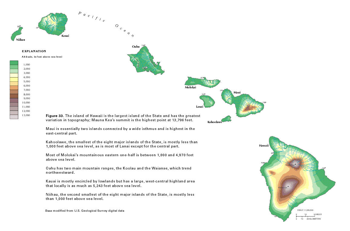
Topography of the Big Island, Hawaii, with elevations in feet. Mauna
Kea (north) and Mauna Loa (south) both exceed 13,000 ft elevation.
Map modified from USGS, "Ground Water Atlas of the United
States. Source.
Hawaiian volcanoes progress through 4 stages, starting with the preshield phase when volcanic activity begins. Stage 2 is the shield stage and is the most active period of volcanic activity when the vast majority of the volcano’s volume is created. Magma rises from the hotspot located as deep as 60-70 below the crust where it is stored in shallow reservoirs. During volcano growth, erupting lava emerges both from the summit of the volcano and from several lateral rift zones. The post-shield stage is next, and consists of additional volcanic activity for about 0.1 to 0.3 million years after the shield stage. Finally, after perhaps a quiescent period, there is the rejuvenated stage, a period of variable length where some additional volcanic activity may occur. The Big Island is the only Island in the shield stage. Landslides and erosion gradually wear down the volcanoes.

There are five volcanoes comprising the Big Island: Kohala, Mauna Kea, Hualalai, Mauna Loa, and Kilauea. Only the latter two have erupted recently. Kilauea is the most active volcano in the world. I hope to see lava flows when we visit the National Park in a few days. A bit to the southeast of the Big Island lies the submerged Loihi, which is the newest volcano in the long Hawaiian chain. Some thousands of years into the future, it may form its own island by breaking the ocean surface or it may merge with its neighbors to grow the size of the Big Island.

The five volcanoes of the Big Island. Map and key modified from Sherrod et al. (2007).


References

Clague DA, Dalrymple GB. 1987. The Hawaiian-Emperor Volcanic Chain. Part I. Geologic Evolution. USGS Professional Paper 1350.

Langenbeim VAM, Clague DA. 1987. The Hawaiian-Emperor Volcanic Chain. Part II. Stratigraphic Framework of Volcanic Rocks of the Hawaiian Islands. USGS Professional Paper 1350.

Sherrod DR. 2009. Hawaiian Islands, Geology. In: Encyclopedia of Islands, Gillespie RG and Clague DA (eds), University of California Press, Berkeley, CA, p.404-410.

Sherrod DR, Sinton JM, Watkins SE, Brunt KM. 2007. Geologic Map of the State of Hawai’i. USGS Open-File Report 2007-1089.

11 October 2015

Signs of the western drought

As I traveled through northern California into Oregon last month, evidence of the severe drought lingering in the west was apparent. Late summer and early fall are typically dry periods in California with the grasses having long since turned golden. But there were perhaps other signs of the on-going drought: water levels at Lake Shasta were very low revealing a large band of reddish soil between the reservoir and the treeline; pines in northern California and southern Oregon appeared stressed; normally glaciated Mount Shasta, nearly the highest point in California, had just thin ribbons of snow on its southern slopes.

Low water levels at Shasta Lake (a major reservoir in northern California).

Pines in the vicinity of Mt. Shasta in northern California and
into southern Oregon looked perhaps unusually stressed with
significant amounts of dead needles.
In California the drought is now in its fourth year, and concern finally reached the level where mandatory reductions in water usage by residential consumers were put into place. Other parts of the west are also in drought. Nevada is nearly as dry as California. Oregon and Washington have had abnormally low precipitation this year. The maps of drought conditions for the United States, updated weekly by the U.S.Drought Monitor, show that the western U.S. as a whole is quite dry.

Mt. Shasta with low snow coverage.
One useful metric of drought conditions is the PalmerDrought Severity Index. The index incorporates both precipitation and temperature information to indicate drought intensity. Values ≤ -4 indicate “extreme drought”; and values between -2 and -4 indicate “moderate” or “severe” drought. Trees are also excellent sentinels of overall environmental conditions because their growth patterns integrate the various stressors they experience such as temperature, soil water content and nutrient availability. Thus tree ring data provide excellent annual historical records of environmental conditions.

On-line I located the work of a team from NOAA’s Nation ClimaticData Center that used hundreds of tree ring samples to study long-term changes in drought intensity throughout the U.S. I downloaded and plotted Palmer Index data for the last 500 years in the northern California region. Tree ring data from 26-55 samples cover this time period. I am definitely not an expert on the science of drought, but to me the data suggest that normally there is substantial year-to-year variation in drought conditions in this region. Some longer-term patterns can also be discerned from the time series. For example, from about 1915 to 1935 – a period coinciding with the dust bowl in the Midwestern US – northern California appeared to be in an extended drought.


Palmer Drought Severity Index data reconstructed for northern California from tree ring data over the last 500 years. The 
blue lines indicate annual values; the thicker red line is a ten year running mean. The time series ends in 2003, so the
current drought is not shown on the figure. Data source: NOAA NCDC.

Recent drought status in the continental U.S. as measured by the Palmer Index. Map source.

Only time will tell if California experiences a fifth year of drought. With a strong El Nino currently developing in the eastern Pacific Ocean, chances are that greater than average precipitation will fall in California this winter and some relief will come. It has also been a warmer year than ever, so more of that precipitation may come as rain rather than snow.

04 October 2015

Crater Lake

Crater Lake National Park was the last significant stop on my recent trip to the Pacific Northwest. Located about 50 miles north of the California border, it is the only national park in Oregon. The park centers on the magnificent lake with its deep, cold, and intensely blue waters.

Crater Lake and Wizard Island (center) from the southwest side of rim drive.

Wizard Island is a small crater that formed inside Crater Lake
after the massive eruption of Mount Mazama (NPS 2013). With
its beautiful shape, it is my favorite feature of the Park.
The crater in which the lake rests was formed by a massive volcanic explosion some 7700 years ago. Prior to this cataclysmic eruption, Mount Mazama was one of the highest peaks in the Cascade Range, reaching about 12,000 feet in elevation (NPS 2013). The area has breathtaking vistas and holds fascinating lessons in geology.

I camped for a single night at Lost Creek campground, a small site among pines on the eastern slope of the mountain. It was the night of the lunar eclipse and blood moon and Crater Lake was the perfect location for sky watching. At about full eclipse in the late evening (approximately 8 PM PDT), hundreds of stars were visible in the darkened sky because of the obscured moon. Later, after the eclipse lapsed, the landscape became much more illuminated from the brilliant full moon. I drove back down the road a few miles from the campsite to the pinnacles area that I had visited just before sunset.

Pinnacles at the southeast side of the park. The discreet bands of color show
the evolving composition of volcanic material as it was erupted from Mount
Mazama 7700 years ago (NPS 2013).
I have made a few day trips to Crater Lake in the past, but saw the pinnacles for the first time on this trip. Formed during the last eruption, they stand as spires on both sides of a wide valley cut into the eastern slope of Mount Mazama. In essence, during the eruption large flows of hot ash poured down the slopes of the mountain. Heated gases rose through the ash to escape into the atmosphere over time, hardening columns of mud (called “tuff”) surrounding the gaseous vents. Finally over time, erosion removed the softer ash but not the more hardened columns of mudstone surrounding the vents, leaving a landscape of spires for us to admire today (NPS 2013).

Crater Lake from the trail at Cleetwood
Cove.


In the morning following a cold night of camping, I hiked down the only trail that leads from the rim of the crater to the lake itself. It is a short but moderately steep trail that passes through light conifer forest. The water of the lake was calm, reflecting sparkles from the sun in the east. At the end of the trail there is a boat launch (for paid tours to Wizard Island), and a small shack housing a water level measurement station. I put my feet in the cold lake in the warm morning sun.

The history of Crater Lake is one of violent geologic forces, but the placid lake and singing birds on a warm morning in early fall, and the green carpets of forest on Mount Mazama’s slopes belied its turbulent past.

Reference
National Park Service (2013). Crater Lake National Park. Geologic Resources Inventory Report. Natural Resource Report NPS/NRSS/GRD/NRR-2013/719


The pinnacles illuminated by the full moon.
The eclipse and blood moon from the Park.