20 March 2016

Death Valley blooms

Geraea canescens (Desert Gold), the most common
wildflower species at low elevations in Death Valley
National Park. Photo taken at Devil's Cornfield.
Deserts present formidable challenges for plants and animals to craft an existence. Access to water is chief among these challenges. Not only must desert organisms be tolerant of lack of water for many months of the year, they must also be capable of capitalizing on the rare and unpredictable opportunities to acquire water when the rains do come.

Death Valley is the hottest and driest location in North America. Lying just east of the Sierra Nevada in eastern California and western Nevada, it is part of the Mojave Desert. The Sierras catch most of the precipitation in the storms that roll in from the Pacific bound for California. Little rain or snow makes it past the formidable granite blockade of the Sierras. One of the largest national parks in the US encompasses Death Valley, along with part of Panamint Valley and the Panamint and Amargosa mountain ranges. The vast majority of Death Valley National Park is designated wilderness area – rugged terrain without roads or human development. 

But rain does come to the desert occasionally. On 18 October 2015, a significant storm drenched the valley, setting the stage for the burst of wildflower color that we are now observing in early 2016. That heavy rainfall event, totaling about as much rain in one day as the valley averages in a year, signaled to a dormant seed bank of desert annuals that this was their chance to germinate and complete another generation. Months later, the wildflower bloom began.

Left: Atrichoseris platyphylla, or the "Gravel Ghost". The flowers (technically inflorescences since this species is
an aster) are a few centimeters in diameter and they sit atop long spindly stems. Photo from Scotty Castle Rd.
Right: Mohavea from Panamint Valley.

Phacelia sp. The bold blooms of this species
were particularly common along roadsides.
Being aware of the current El NiƱo in the Pacific, I had already planned a trip to Death Valley months ago with a hope that the floral display this spring would be impressive. However, when I started to hear media reports in late February of the “superbloom” sweeping Death Valley, I decided to move my visit up a few weeks on the calendar. With a dry and warm February in northern California, it seemed that spring had really come early to California this year and I didn’t want to miss my chance!

Most of the flowers during my trip in the first week of March could be seen from below sea-level to about 3000 ft elevation, including in Death Valley and Panamint Valley. Above 3000 feet, flowers could be observed in a few locations – including the flowering Joshua Trees (Yucca brevifolia) along Wildrose Road and Indian paintbrushes (Castilleja) and others near Daylight Pass along the California-Nevada border. A report from the park in late February suggested that the densest fields of flowers could be found in the Badwater Road area, a part of the park that I did not visit. However, there were relatively dense concentrations of yellow blooms of Desert Gold (Geraea canescens) near Furnace Creek and Salt Creek.

The beautiful Eremalche rotundifolia (Malvaceae).


My favorite species in bloom was a small mallow, Eremalche rotundifolia, commonly called the “desert five-spot”. The delicate pink petals of this flower form a cup, so one has to peer inside from the top to see the rest of the flower. From that perspective, one can see that each petal has a dark red splotch at its base. The desert five spot was not particularly common in the areas I visited, but it occurred in both Panamint Valley and Death Valley between Furnace Creek and Stove-pipe wells. Another mallow, also with very showy flowers hosting peach-colored petals (the Apricot Mallow), appeared to be even more rare; I only observed two plants during the two day trip. 

Sphaeralcea ambigua, Apricot Mallow.
Deserts host their own beauty – from clear night skies to fascinating geological landscapes to bright bursts of wildflower color. The paradox of life is transparent in the desert – a place where harshness and beauty plainly co-exist.

References

Baldwin GB et al. (ed). 2012. The Jepson Manual. 2nd ed. University of California Press, Berkeley, CA.

Milliard D. 2016. Wildflower update 2016. National Park Service website.

Munz PA. 1962. California Desert Wildflowers. University of California Press, Berkeley, CA.

National Park Service. 2016. Death Valley National Park Visitor's Guide, Winter/Spring 2016.


Left: Creosote bush (Larrea tridentata), the most common larger shrub in Death Valley. Many of the plants were
in bloom. Center and right: Two other unidentified species.
Mimulus bigelovii. Plants bearing these flowers were typically
very short in stature. One population of this species grows in a
small canyon at the base of hills near Big Pine Rd. 
A Joshua Tree, Yucca brevifolia, in bloom. I noted two populations of
Joshua trees in and around Death Valley National Park, both growing at
elevations in excess of about 4000 ft. This tree was in a population
along Wildrose Rd.
Chylismia brevipes was one of the most common blooming species
I saw in early March. The petals are often solid yellow, but sometimes
have red spots as in this example from along Big Pine Road at the
north end of the park.

21 February 2016

Incredible plants: Costaria costata

Small sporophytes of Costaria costata in an intertidal
pool at Carmel Pt., Monterey Co., CA, June 2014.
Kelps are undoubtedly one of my favorite groups of plants – “plants” in the broadest sense of the word since they belong to an order of brown seaweeds (Laminariales) that are quite distinct evolutionarily from land plants. Among the dozens of kelp species along the world’s coasts, Costaria costata is one of my favorite species. It tends to be just rare enough that it is a pleasant surprise to find it during a visit to the rocky intertidal, and it also has such a remarkable and intriguing shape.

Like many of the smaller kelps that don’t form tall canopies in kelp forests, the macroscopic stage of Costaria consists of a single large blade. However, the blade is very distinct, making the species easy to identify in the field. It has 5 raised ribs that run longitudinally along the blade. In between these ribs, the surface of the blade is raised and lowered in textured undulations. Sometimes the blades have holes in them and oftentimes the end of the blade is tattered and torn from thrashing among the rocks and surf. The blade of the plant is held to the rocks by a short stipe and a holdfast of branching haptera that resemble roots, but the holdfast function is largely for anchoring the kelp to the rocks. The blades can reach up to 2-3 m in length. The stipes have a corrugated rather than smooth surface, a feature that I think is unique among all the kelp species along the western US coast.

Specimens of Costaria costata from Pacific Grove, Monterey Peninsula (left) and Iwate Prefecture, northern Japan (right) collected in 1897 and 1986 respectively (UC Berkeley herbarium specimens UC96712 and UC1829920). The five midribs and bullation on the surface of the blade are obvious on the specimen from California. the blade in the plant from Japan has numerous round perforations which are only seen on some individuals.
Costaria costata (right) and a related kelp, Dictyoneurum
californicum
(left), from Mendocino Co., CA, July 2008.
Thecorrugated surface of the stipe is easily observed in
this photograph.
Costaria is an annual like its cousin the sea palm that I highlighted in a previous post (Druehl 2000). As with other kelps, it has a microscopic gametophyte stage that grows cryptically on the rocks. Only the large sporophyte is visible to the casual observer, and being an annual it will most likely be easiest to find during the summer. The sporophyte produces spores in the blade from summer to fall that eventually make their way to the substrate to germinate into male and female gametophytes.

Broadly speaking, Costaria is reportedly distributed from southern California through Alaska to northern Japan in the northwestern Pacific. However, the actual site-by-site occurrence along the coast is much more spotty. Unlike very common kelps such as Egregia menziesii or Laminaria setchellii, one won’t find it at most stretches of rocky intertidal coastline. I have personally observed Costaria at Carmel Point (just south of Monterey, California); Glass Beach (in Mendocino County, CA); on San Juan Island, WA; at Botanical Beach in southern British Columbia; and at a few other west coast locations. From herbarium records I’ve compiled at regional museums (UC Berkeley, Humboldt State Univ., etc), other locations where the species has historically been found include: the Monterey Peninsula; Shelter Cove; Humboldt County; Sunset Bay and Newport, Oregon; Whidbey Island, Washington; southeast Alaska; and Hokkaido, Japan. Skimming through my herbarium notes, I haven’t seen any specimen records farther south on the US Pacific coast than Big Sur, California.

Costaria costata and Cymathere triplicata in the low intertidal at Botanical Beach,
Vancouver Island, British Columbia, summer 2000. These two kelps co-occurred on
rocky substrate with numerous urchins nearby. Urchins are typically voracious
consumers of kelp, but these plants had so far escaped herbivory. Cymathere, a kelp
from the Pacific Northwest, is distinguished from Costaria by having a smooth blade
and only 3 longitudinal ribs.

Links to other web resources on Costaria costata:
-          The late Tom DeCew’s Guide at the University Herbarium, UC Berkeley
-          British Columbia coastal biodiversity page by the Starzomski lab
-          Seaweeds of Alaska on-line flora

References

Abbott IA, Hollenberg GJ. 1976. Marine Algae of California. Stanford University Press.

Druehl L. 2000 Pacific Seaweeds. Harbour Publishing.


08 February 2016

The most isolated islands

More than any other factor, isolation has shaped the community of organisms present on the Hawaiian Islands. At least this is a reasonable prediction, if we apply principles of island biogeography. According to this classic theory developed by ecologists Robert MacArthur and Edward O. Wilson, species composition on islands is determined by patterns of colonization and extinction over time. Overall species diversity on an island is affected by its distance from a colonizing source (e.g., a mainland) and by the island’s size. Small islands and isolated islands tend to have lower diversity.

Pacific ocean basin bathymetry/topography with the WNW to ESE trending
Hawaiian Island chain and the N to S trending Emperor Seamounts. Base
map from NOAA, NCEI. Source.
The isolation of Hawaii is due to the nature of how the islands were formed geologically. The Hawaiian chain sits in the middle of the vast Pacific crustal plate underneath the largest ocean basin in the world. For tens of millions of years, a geologic hotspot below the crust has continuously burped up magma to the crustal surface, forming some of the tallest mountains in the world. Because of their birth from an undersea hotspot underneath the Pacific plate, the islands have never been connected to the mainland of any continent. Other hotspots dot the planet, but Hawaii is remarkably distant from all other land masses. One of the nearest islands is Kirimati (Line Islands) at about 2000 km away; the distance from Hilo to San Francisco is over 3700 km.

For terrestrial plants and animals, successful colonization of Hawaii came only by long-distance dispersal over thousands of kilometers of ocean. For example, plant colonists may have had seeds that were highly tolerant of salt water, or capable of hitchhiking on birds that landed on the islands. Seed studies suggest that about one third of Hawaiian species arrived there by drifting or rafting over the surface of the ocean; the remaining species probably came with birds. For ferns (which reproduce by small spores, not seeds) many species probably came as winds carried their lightweight spores long distances through the atmosphere.

By looking at the kinds of native organisms present in the terrestrial flora and fauna of a very isolated archipelago like Hawaii, we can infer something about differences in the dispersal ability of those organisms. For example, the native biota of the islands is missing some major groups of animals commonly present on continents: ants, termites, reptiles and amphibians. Mammals are also very rare in Hawaii – restricted to bats and the endangered monk seals. These groups of organisms simply have never naturally colonized Hawaii because the distances are too great, the oceanic environment too hostile, or chance was never in their factor.

Relationship between number of native plant species and
island area for 10 of the Hawaiian Islands (8 main islands
+ Nihoa + Necker). Data are from Evenhuis and Eldredge
 (2004) and Gustafson et al. (2014). The Big Island is some-
what of an outlier, but this may be reflective of its relative
youth in the island chain.
Isolation has led to high rates of endemism on the Hawaiian Islands. Endemic species are those found in a single location, but no where else. Today Hawaii has an estimated 1207 species of native vascular plants, and a remarkable 88% of them are endemic to the island chain. Some of the individual islands also have local endemics. For instance Kauai has 219 endemic plant species while the younger islands of Oahu and Maui have 140 and 89 endemic respectively.

Isolation has affected which species have been able to reach the islands, but other factors more local to the islands have subsequently influenced the evolution of the successful colonists. Each island in the Hawaiian archipelago has a life cycle of perhaps 5-20 million years from birth to erosion and subsidence to its final days as an atoll. The Big Island is youngest at no more than 1 million years; Kauai and Nihau are the oldest of the major islands at about 6 million years old. So, for some of the earliest colonizing lineages of organisms, their long-term persistence on the archipelago may be due to an ability to hop from island to island. As an older island finally sinks back into the Pacific during its old age, species that can colonize a younger island would persist. Interestingly, many of the species present on the islands today appear to have evolved from colonists that arrived not more than about six million years ago (about when Kaua’i formed) suggesting that island hopping isn’t particularly common.  

The honeycreeper, Vestiaria coccinea, on Acacia koa
(Fabaceae). Photo by Ludovic Hirlimann, CC BY-SA 2.0
license. Source.
The Hawaiian biota is a good example of adaptive radiation, the evolutionary process that results in a large and diverse group of species diverging from a single successful colonizing species. Good examples of adaptive radiation include the silversword plants and the Hawaiian honeycreepers (birds).

Studies of similarities and differences among DNA sequences – a powerful tool to discern relationships among organisms – has also shed some insight into the history of colonization on the islands. For the approximately 1200 native plants currently growing in Hawaii, it is believed that historically there were about 375 separate successful colonizing events. Because colonization and local extinction of species on islands is a continuous process, there were likely more successful colonizations over the geologic history of the islands, but some of those lineages went extinct. We can also speculate that there were probably many more near misses where colonizing seeds or spores arrived on the shores of Hawaii but failed to become established, perhaps because they didn’t arrive in densities high enough to successfully reproduce.

Of the nearly 400 plant colonizations resulting in the contemporary Hawaiian flora, about two thirds have left us with only a single living species. The rest have radiated into groups of related plants. For example, the lobeliad plants now comprise 6 genera and 141 species, each derived from what is believed to be a single colonizing event 13 million years ago. The lobeliad radiation has resulted in a diversity of plant types from succulents to shrubs to trees. Hawaiian radiations have sometimes occurred with little genetic differentiation among the species but much ecological differentiation. An example would be the ohia lehua tree (Metrosideros), which I wrote about in a previous post, a species that varies considerably in size and morphology. In contrast, other radiations can result in much genetic diversity among a group of ecologically-similar species. For instance, a single colonizing event for the genus Cyrtandra has resulted in 59 different endemic species of forest plants, all of which live as forest understory trees or shrubs, and may therefore be pretty similar ecologically.

Isolation and endemism – some of the features that make the Hawaiian biota a remarkable laboratory of evolution – also are coupled with significant threats to biodiversity on the islands. With so much unique biological richness there is much to lose. I’ll discuss threats to Hawaiian conservation in a later post.  

References

Evenhuis NL and Eldredge LG. (eds) 2004. Natural History of Nihoa and Necker Islands. Bishop Museum Press, Honolulu, HI, 220 pg.

Gustafson RJ, Herbst DR, Rundel PW. 2014. Hawaiian Plant Life. Vegetation and Flora. University of Hawaii Press, Honolulu, HI.

Price J. 2009. Hawaiian Islands, Biology. In: Encyclopedia of Islands, Gillespie RG and Clague DA (eds), University of California Press, Berkeley, CA, p.397-404.

10 January 2016

Ice textures


Last weekend, in response to a request for a snow day from the kids, we drove up into the Sierras to Bear Valley near the intersection of Interstate 80 and California route 20. We’ve explored the area several times before, mostly in the winter when it is blanketed in snow. The South Fork of the Yuba River crosses through the area. More a stream than a river at this elevation, its bed is littered with large smooth boulders, each topped with caps of bright snow this time of year.

Umbilicaria sp. on a snow-covered boulder.
Conifers (pines and stately incense cedars), and the grey skeletons of dormant deciduous trees comprise the forest in the area. Where there are gaps in the snow (or on the steeper sides of rocks where snow doesn’t collect), there are vibrant green mosses and a palette of lichens from yellow to chocolate brown species. The brown species (an Umbilicaria I believe) has a peltate form, attaching to the rocks like a very stout mushroom, the margins of the plants unattached. There are black spots on the thalli, varying in size and shape that resemble tar spots. These are the apothecia of the fungi where spores are produced.


Tufts of moss in little ice caves.


The area is generally pretty, but not necessarily remarkable. Winter, with its cover of snow however, brings a freshness that accentuates the mystery of the landscape, rounding the shapes under the blanket, and revealing underlying bedrock or biota here and there. I spent some time looking closely at the ice surfaces, these remarkable in their detail. Here are some close-up photos of different ice shapes and textures.

Reference(s)

Brodo IM, Sharnoff SD, Sharnoff S. 2001. Lichens of North America. Yale University Press, New Haven.

Close-up view of the textured surface of icicles. Each irregular polygon, looking remarkably like a cluster of cells, was on hte order of a few millimeters in size. 


Brittle ice crystals over a bed of moss.


03 January 2016

Incredible plants: 'ohi'a lehua

'Ohi'a lehua (left) with Kilauea caldera and its
venting volcanic gases in the background.
The ‘ohi’a lehua, Metrosideros polymorpha, is the most common native tree species in Hawaii, distributed from near sea level to over 8000 ft elevation.

Metrosideros is a member of the Myrtaceae (myrtles), a family distributed throughout the world’s tropics. The most species-rich genus in the family, Eucalyptus, is likely familiar to many North Americans, since they have been planted throughout urban areas such as southern California (they are native to Australia).

The flowers of M. polymorpha look like small floral fireworks, because of long stamens that protrude from the flowers. The stamens are usually red, however, true to its species epithet (“polymorpha”), stamen color is variable, as are a number of other morphological features of the plant including tree size, and leaf hairiness.

The ‘ohi’a lehua is an early colonist of fresh lava flows and was present in the patchwork of recent lava flows that were visible along Chain of Craters Road in Hawaii Volcanoes National Park. It was also present in more densely forested areas of the park including the northern rim of the Kilauea Caldera and the Ola’a Forest tract – a small wilderness area in the National Park near the town of Volcano that is thick with tree ferns and bryophytes.

Close-up of leaves and flowers. The photo at left was taken near the steam vents in the Kilauea caldera. Note the relatively smooth leaves. The image at right was taken near the trailhead to Mauna Loa, at a higher elevation. the leaves are hairy and flower buds have not yet opened. 

Since the Hawaiian Islands have never been connected to any mainland, all terrestrial species present on the islands originally traveled over large expanses of ocean from other locations. In the case of M. polymorpha, DNA sequence data suggests that it may have colonized from the Marquesas Islands in the south Pacific. Other species in the genus Metrosideros are common in the southern hemisphere, and M. polymopha’s closest genetic relative is M. collina from the Marquesas. The ancestor of today’s M. polymorpha is estimated to have made the migration to Hawaii about 0.5 to 1.0 million years ago, about the time the Big Island was just emerging as the newest Hawaiian island from the vast Pacific.

Trees colonizing a lava field along Chain of Craters Road in Hawaii Volcanos
National Park.

Trees along the coastal slope, south side of the Big Island.
Interestingly, ‘ohi’a lehue trees on the Big Island have been in the news much recently because of concern over a disease outbreak termed “rapid ohia death”. The causative agent appears to be a fungus, Ceratocystis fimbriatus. The disease has apparently not yet spread to other islands in Hawaii, but it poses a significant threat to native forests if its spread continues. Also notable is the fact that rapid ohi’a death isn’t the first documented disease to threaten ohi’a trees over the decades. I located references to two other fungal diseases of these trees: ohi’a rust that affects seedlings in nurseries, and die-offs of mature trees in forests on the Big Island that may have been attributable to Armillaria. Of course, many organisms have evolved in concert with pathogens over their evolutionary history, but new invasions facilitated by human movement of pathogens could cause alarming ecological change to ecosystems unaccustomed to the presence of new diseases. Where did the rapid ohia death pathogen come from, and what will it mean for the future of Hawaii’s native forests?

References

Bohm BA. 2004. Hawai′i’s Native Plants. Mutual Publishing, Honolulu, HI.

Burgan RE, Nelson RE. 1972. Decline of ohia lehua forests in Hawaii. Pacific Southwest Forest and Range Experimental Station, Berkeley, CA. USDA Forest Service General Technical Report PSW-3.

Judd WS, Campbell CS, Kellogg EA, Stevens PF, Donaghue. 2008. Plant Systematics. A Phylogenetic Approach. Sinauer Associates, Sunderland, MA.

Lamoureux CH. 1996. Trailside plants of Hawai′i’s national parks. Hawai′i Natural History Association.

20 December 2015

Notes on some sea urchins of Hawaii

Map of the Big Island with intertidal and subtidal sites I
visited this fall. Map modified from this source.
Sea urchins were one of the prominent groups of marine invertebrates I encountered while exploring the intertidal and shallow subtidal of the Big Island’s coastline. Click here for a checklist of species published by the Bishop Museum. Some notes on a few common species:

1. The slate pencil urchin, Heterocentrotus mamillatus. This was the most striking of the species I found on the Big Island. Thick brick-red spines emerge from the body which is whitish or deep red. This species was present in both the low intertidal and the subtidal, including in coral reefs where it was often found in crevices. I was common along the Kona side of the Big Island.


Heterocentrotus mamillatus. Left: low intertidal urchin from Miloli'i. Right: subtidal animal at Old Kona Airport.

2.  Echinometra mathaei. This species was the most abundant overall in my coastal visits, commonly occurring in both intertidal pools and on subtidal reefs in high densities. The test diameter and spine length are both on the order of a few cm. Body color varied from a pale green to pink color. This species reminded me of Strongylocentrotus purpuratus, the common purple urchin of coastal California waters, in terms of size and morphology, and by its tendency to hide in small holes in the rocky substrate, perhaps sheltering there from predators.

Echinometra mathaei. Left: At Miloli'i; right: at Wai'opae.
The collector urchin, at Puako Bay.

3. The collector urchin, Tripneustes gratilla. Typically a subtidal species, it is purple to black overall, but often has at least some whitish and reddish spines. This species was common at Puako Bay where living coral cover appeared sparse, but there was significant cover of encrusting red coralline algae. It was also present at Honaunau Bay, Keauhou, and the Old Kona Airport on the Kona side of the island. The collector urchin is distributed in tropical waters of the Pacific and Indian Oceans.


4. The helmet urchin, Colobocentrotus atratus. This is a common intertidal species, usually black in color. Most of the spines on the body have been reduced to armor-like plates, while those near the sides are elongated to form a skirt around the animal. This species appears to favor more wave-swept coastlines and the overall shape probably minimizes hydrologic drag on the body. This species is probably a major intertidal herbivore, suggested by the barrens of pink corraline algae I often found in the vicinity of the animals. I observed this species at Ka Lae, Miloli’i, the Old Kona Airport, and Waikui Beach in the south Kohala District.

Colobocentrotus atratus. Both photos are from the intertidal at Keauhou, south of Kona.

5. Echinothrix calamaris, the banded urchin. This is a larger black urchin with menacing spines, occurring as either an all-black morph, or with white and black-banded spines. From my observations, the black morph was much more common on the Big Island. I found this species from intertidal tidepools to the subtidal. It was common at Waikui Beach and the shoreline near the Old Kona Airport. Also present at Honaunau Bay.

Two color morphs of Echinothrix calamaris. Left: subtidal at Honaunau Bay; right: subtidal at Waikui beach.
 
Close-up of Echinometra mathaei, with tube feet visible among the spines (white arrows).

Subtidal slate pencil urchins in coral at Waikui beach.
Reference

Stender K, Yuko K. 2014. MarinelifePhotography.com.

06 December 2015

The northern Hawaiian coast

Geographic regions of the Big Island. Map source
The northwestern district of Kohala and the Hamakua coast were among the final regions we visited while making a loop around the Big Island. Like Kau to the south, these areas less populated than the Kona and Hilo coasts, scattered only with small towns, farms, and impressive vistas of open space. There are a series of green valleys sculpted into the northeast-facing coast of Hamakua, largely inaccessible except by hiking.

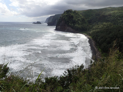
From the North Kohala side, at the terminus of state road 270, is Pololu Valley. It appeared to have an estuary of sorts, with a sediment-laden chocolate stream that wound back into the valley. The mouth of the stream had a shallow connection to the ocean because of the buildup of large cobbles on the beach. Visible to the east were cliffs and a few offshore islets. The wind was strong here, stirring up numerous white caps out at sea. To me, the whole scene was reminiscent of portions of central California in some degree, like the rough coastal gem of the Big Sur area. 

The northwest coast of Hamakua from the overlook
above Waipio Valley. A waterfall nearly reaches
the beach.
Waipio Valley is also among this chain of coastal valleys. The valley used to be a prosperous settlement, both during Polynesian rule of the Hawaiian Islands and more recently. Hawaiians referred to it as the ‘Valley of the Kings’ (Barth 1995). A devastating tsunami in 1946 obliterated the area, and resettlement has been sparse. From Waipio Valley, there is a trail that heads northwest to the next coastal valley (Waimanu Valley) which would be a treat to backpack some day.

Down in Pololu Valley, the shore was rough with wind, waves, and a beach covered in cobbles of lava rock worn smooth by the surf. There also was a significant amount of debris – bottles, fishing buoys, decaying buckets. These items may have traveled thousands of miles to land on the shores of Hawaii. With some help from the kids, we gathered up a number of items to remove them from the beach.

Pollution is a distinctly visible reminder of humankind’s impact to our most cherished natural areas. It is particularly unwelcome on our beautiful coastlines. Yet, visibility aside, it is probably one of the lesser human impacts to the oceans. Habitat destruction, overfishing (which disrupts entire food webs), and changing climate are perhaps more pernicious threats to ocean biodiversity and function.


Pololu Valley.
A black cobble beach at Pololu Valley and the cliffs of the Hamakua coast in the distance.

Flying for hours over the vast Pacific, the immensity of the global ocean is made apparent. Individually, we are barely specks on this immense globe, so it is perhaps natural to assume that our species can have little impact on this globe. Yet evidence from every line of science points otherwise. When tsumani debris bearing living organisms arrives on the shores of Oregon from Japan (as I was able to observe firsthand a few years ago), it becomes apparent just how close supposed distant places are to each other. Our collective human impacts on our planet have become pervasive.

The kids helped gather marine debris washed ashore at Pololu Valley.

Coastal topography near Pololu Valley, from 1995 USGS topographic map, Honokane, HI.
Reference

Barth S. 1995. The Smithsonian Guides to Natural America. The Pacific. Smithsonian Books, Washington D.C.

01 December 2015

Wai'opae pools

Wai'opae pools among basalt bedrock and boulders.
The Big Island has about 6 Marine Life Conservation Districts, marine reserves established by the state of Hawaii that variously protect coastal marine organisms from harvest. A short stretch of coastline containing the Wai’opae pools is the only MLCD on the eastern end of the island. The site is southeast of Hilo, near the town of Kapoho, tucked behind a few coastal residences.

At Wai’opae the dark lava is spread in a wide flat bench that creates a broad area of pools between emergent rocks. Some of the pools are shallow and might be properly considered “tide pools”, but others are deeper and create permanent subtidal habitat. Partly isolated from each other, each pool is a small reef ecosystem.

Purple ember parrotfish, Scarus rubroviolaceus followed by an endemic saddle wrasse, Thalassoma duperrey among convict tangs.

Closeup of coral polyps.
 Saturday I spent several hours exploring five pools, ranging in size, depth and species composition. My son Ben located the first, a deep pool with a few corals and a moderate number of fish located far inshore from the breaking waves off shore.

Later I spent a little time in a round pool not wider than 5 or so few meters across, with black basalt enclosing a cozy aquarium. One side of the pool was shallow, the other deep, but each with a number of brown plate corals. The colonies of this species form rounded shelves against the rocks like shelf fungi that grow on trees or fallen logs in a temperate forest.

The last pool I explored was the largest and had the most obvious active connection to the ocean, indicated by a strong current present at the southeastern end. I was already cold at this point in the afternoon, but I probably ended up staying another hour in this pool. The axis of the pool was like a shallow V-shaped valley, along which I swam back and forth several times. Fish abundance in the pool was remarkable, and included wrasses, butterflyfish, large purple and greenish parrotfish, and a dense school of striped convict fish accompanied by several large black colored fish that swam with their smaller associates. Blue needle fish were common in the surface water, creating a ring around me, but keeping some distance.

Unidentified blenny perched in coral in a shallow pool.

The pools I observed did not have continuous coral cover. In fact, at some had just a few percent cover. Rather, corals appeared as discreet colonies, with bedrock, volcanic rubble, or fuzzy algal turfs occupying the rest of the space. They seemed absent from the shallowest areas, perhaps because these are exposed a low tides. Lobe (Porites sp.), lace, and plate corals were common. In the pools I found few species of larger macroalgae, but notable exceptions were a single siphonous green alga (?Caulerpa sp.) shaped not unlike an immature bunch of green grapes, and dichotomously branched thin blades of an attractive red foliose alga. Larger invertebrates included beautiful slate pencil urchins and two species of holothuroideans (sea cucumbers).

A school of convict fish.

Green siphonous macroalga, perhaps Caulerpa sp.

Plate coral.

Needlefishes swimming near the water surface.

Hawaiian whitespotted toby, Canthigaster jactator.

The common saddle wrasse, Thalassoma duperrey. Many wrasses change sex over
the course of life. This fish is an "early stage" male or female. "Supermales" have a
white vertical mark behind the reddish band.


References

Hoover JP. 2014. Hawai’i’s Fishes. A Guide for Snorkelers and Divers. 2nd ed. Mutual Publishing, Honolulu.

Krupp D. 2010. Hawaiian Coral Index Page: http://krupp.wcc.hawaii.edu/BIOL200/hawcoral/corindex.htm

Mahaney C, Witte A. 1993. Hawaiian Reef Fish. Blue Kirio Publishing.