14 July 2016

Oregon caves

Valley leading up to Oregon Caves
National Monument.
The Oregon Caves National Monument lies in the Siskiyou range, a mountainous region in southwest Oregon rich in biodiversity.

Dozens of chambers and tunnels connect the caves in a complex underground maze discovered by Elijah Davidson in 1874 while in pursuit of his dog and a bear that had entered the cave. The caves became a popular attraction; today the National Park Service leads tours of a little over an hour through much of the cave complex.

"Drapery" formed by sheet flow of water though
the cave.
The caves formed over the course of thousands of years as weak carbonic acid slowly dissolved the marble rocks underlying the mountain. The acids formed from the interaction of water with carbon dioxide released from decaying plant matter in the soils overlying the bedrock. The caverns and tunnels vary in size and shape. A very small stream (named the “River Styx”) runs through a part of the cave complex.

Slow mineral deposition over time as water continues to move through the caves has resulted in a variety of interesting forms inside many of the rooms. Dripping water creates forms such as stalagmites and the thin “soda straws” that project from some of the cave ceilings. Flowing sheets of water over rock surfaces form other shapes such as “drapery”. Lights set up by the Park Service help illuminate many of the features for visitors. 

Other cave features: stalagmites, stalactites, and
columns (fused stalagmites + stalagtites).
Drapery is most ornate in the "Paradise Lost" room,
my favorite place along the tour route.
Other reference

National Park Service educational materials

12 July 2016

Crescent City rocky intertidal

The northern-most significant stretch of rocky coastline in California borders the small sleepy town of Crescent City. Last week offered some excellent early morning low tides, so of course part of the Pacific Northwest vacation needed to be scheduled around a few coastal adventures.

Pebble Beach area, Crescent City, exposed at low tide.

The Crescent City coastline consists of a long stretch of boulders (small and large) punctuated with offshore rocks and seastacks. At low tide the intertidal life is rich, especially abundant with red seaweeds. One of the species occurring distinctively here is the small peltate red alga Constantinea simplex. It grows in the low intertidal, mushroom-shaped, along vertical rock faces.

Every visit to the intertidal reveals some treasures - often new species or observations. Some highlights from this low tide excursion:

- a bright orange sea cucumber, unknown species
- a low intertidal pool with a long orange nemerteam worm, some bashful large sculpins, and little orange cup corals (Ballanophyllia elegans)
- abundant Desmarestia munda
- yellow dorid nudibranchs and a few other species

The early morning tide was quite low and the wind and sea were calm - perfect conditions for exploring the low intertidal.

A gray-blue species of sculpin in a shaded shallow intertidal pool.

The orange cup coral, Balanophyllia elegans.

Dermasterias imbricata.

Unidentified sea cucumber.

09 July 2016

Oregon redwoods


According to the fossil record, redwoods once occupied a large expanse of territory across North America. Today they are restricted to a narrow coastal band along the Pacific coast where year-round temperatures are mild.

The modern day range of Sequoia sempervirens stretches from Big Sur in Monterey County, California to just across the California-Oregon border. At the southern end of the range, the trees tend to be shorter, tucked away inside steep valleys cut into the Big Sur coastline. They may survive courtesy of tongues of fog that roll in from the cool Pacific into the coastal valleys, while finding the dryer warm hillsides too inhospitable. Towards the northern end of the range in Humboldt and Del Norte counties, the redwoods reach their most favorable conditions, at least as evidenced by the size of the trees. In Tall Trees Grove in Redwood National Park in northern California, for example, several contenders for the world's tallest tree thrive near Redwood Creek.

Though I have spent much time among the redwoods throughout much of their range, until this week I had never seen the northernmost trees in the southwest corner of Oregon. The occasion was the first leg of a Pacific Northwest vacation in northwestern California and southeast Oregon. After an early morning exploration of rocky tidepools in Crescent City, I thought it would be an opportune time to make a detour to find the redwoods before heading to Oregon Caves National Monument (hopefully more on these adventures in later posts).

After crossing into Oregon heading north on US101, one heads east to follow the course of the Winchuck River for a few miles and then turns off onto a narrow one-lane road that winds into the western reaches of the Rogue River Siskiyou National Forest. About 2-2.5 miles into the road, the distinctive clusters of redwoods begin to appear among other conifers and at 4 miles the road ends and the Oregon redwood trail begins.

Redwood sorrel and wild ginger.


Maianthemum sp. 
The old growth forest hosts the typical consortium of understory species in Sequoia forests: carpets of redwood sorrel, tufts of sword ferns, and rhododendrons. I also observed huckleberry bushes, wild ginger, and a few orange tiger lilies.

Reference

Turner M, Gustafson P. 2006. Wildflowers of the Pacific Northwest. Timber Press, Portland, OR.

05 June 2016

Granite Chief Wilderness

Lake and stream in the Granite Chief Wilderness.
The Granite Chief is the northern-most wilderness of the high Sierra, located west of Lake Tahoe and north of Desolation Wilderness. Up to about 7000 feet, most of the snow in this part of the Sierra has now melted. However, at in the Five Lakes basin to which I hiked last weekend (about 7000 ft elevation), most of the ground was still covered with snow, hardened presumably by repeated melting and refreezing. The firm ground made for easy hiking, though once up in the vicinity of the lakes, I lost much sense of where the existing trails were supposed to be.

The lakes were mostly frozen, but thawing. At the third lake I arrived at a thin transparent sheet of ice like glass was just receding from the edge of the shore. Water flowed out of this lake and fed an active stream that rumbled through naked deciduous trees down into a valley.

Phlox, Granite Chief Wilderness.


Without discernible trails, I didn’t venture far into the wilderness, but did hike up a ridge of exposed granite boulders that overlooked the lake basin. Here little carpets of Phlox were abundant. The flowers amass in dense aggregations of white to pinkish 5-lobed disks, each corolla of petals fused towards the base, protecting a few partly recessed bright orange stamens. There were also orange-red paintbrushes and yellow stalks of wallflowers blooming too, but Phlox was most abundant.

I made an effort to identify the common conifer species in the area; learning the diverse conifer flora of the western US is one of my long-term goals. By far, pines and firs dominated the landscape. I felt moderately confident identifying western white pine (Pinus monticola), lodgepole pine (Pinus contorta), California white fir (Abies concolor), and red fir (Abies magnifica). However, distinguishing the fir species was sometimes a challenge, particularly when the trees were small. I also found a mountain hemlock (Tsuga mertensiana; this species is common in the Three Sisters Wilderness of Oregon) and a lone gnarly Sierra juniper (Juniperus grandis), an old sentinel on the granite ridge overlooking the lake.

Juniperus grandis.


Reference

Kauffmann ME. 2013. Conifers of the Pacific Slope. Backcountry Press, Kneeland, CA.


31 May 2016

Yosemite IV: Glacier Point

Looking southwest into Tenaya Canyon
with Yosemite Valley in the distance.
I took a quick weekend trip to Yosemite this month. The waterfalls were full; the new foliage on hardwood trees was bursting forth like lime green jewels. There were two new destinations on this trip for me: a hike into Yosemite wilderness on the northwest wall of Tenaya Canyon and a drive to Glacier Point on the southern rim of Yosemite Valley. Both afforded incredible views of Half Dome, Tenaya Canyon, Yosemite falls, and the other gems lying at the heart of the park.

From atop Glacier Point it was easy to see how crowded and developed Yosemite Valley has become. Meadows, forests and the sinuous Merced River still occupy most of the valley floor, but the roads and clusters of cars are in plain view from above. John Muir described the view as follows: “From Glacier Point you look down 3000 feet over the edge of its sheer face into the meadows and groves and innumerable yellow pine spires, with the meandering river sparkling and spangling through the midst of them. Across the Valley a great telling view is presented of the Royal Arches, North Dome, Indian Canyon, Three Brothers and El Capitan, with the dome-paved basin of Yosemite Creek and Mount Hoffman in the background. To the eastward, the Half Dome close beside you looking higher and more wonderful than ever; southeastward the Starr King, girdled with silver firs, and the spacious garden-like basin of the Illilouette and its deeply sculptured fountain peaks, called ‘The Merced Group’; and beyond all, marshaled along the eastern horizon, the icy summits on the axis of the range and broad swaths of forest growing on ancient moraines, while the Nevada, Vernal and Yosemite Falls are not only full in sight but are distinctly heard as if one were standing beside them in their spray.” – The Yosemite, 1912. 

View from Glacier Point. Tenaya Canyon entering Yosemite Valley in the foreground. Half Dome to the right.
Left: Vernal Falls. Right: Yosemite Falls.

22 May 2016

Mill Creek at Big Sur

Macrocystis pyrifera (giant kelp) growing in a shallow pool in the intertidal.
Big Sur is one of my favorite places along the northeastern Pacific coast. Here the Santa Lucia Range presses against the Pacific coast, forming rugged rocky shoreline next to steeply cut valleys filled with redwoods and hillside slopes of chaparral and grassland.  

Much of the area is designated as California State Parks or National Forest (including wilderness) land. Big Sur has the usual California problems of invasive species, but the area has historically endured relatively little development. Tourists stream in along Highway 1 (in seemingly greater volume), particularly from the Monterey Peninsula, but much of the shoreline and coast range is too rugged for heavy human use.

I have a few favorite intertidal locations in Big Sur that I’ve visited intermittently over the years to tidepool, photograph marine life, or just collect seaweeds. Actually, quite a bit of the coastline is relatively inaccessible because of its steep topography, or for other reasons. For this month’s early morning spring tides, I visited Mill Creek on the southern Big Sur coast. Because of the early morning tide, I camped Sunday night at Plaskett Creek, and then Monday morning was lucky to have Mill Creek’s rocky stretch of coastline to myself.

Sea stars at Mill Creek, including Henricia leviuscula (center) and two examples of what may be
Leptasterias, a species complex of 6-armed Pacific coast stars. 

Desmarestia munda, acid (!) "kelp".
Excellent low tides notwithstanding, large swells offshore can keep the low intertidal relatively inaccessible for those wishing to stay relatively dry, but one solution to this is to don a wetsuit, at least up to one’s stomach, and make way into the low intertidal and the deeper intertidal pools. With some decent off-shore waves, this trip benefited from that method and I was able to access the deeper pools and photograph quite a few marine treasures with my underwater camera.

Mill Creek has a good mix of seaweeds (large brown seaweeds, foliose and finely-branched red algae, and some green algal species), seagrass (Phyllospadix) and invertebrates (anemones, seastars, mussels, etc.) – an example of a high diversity, less disturbed stretch of central California coastline. The substrate here is a field of large boulders, a cobble beach, and larger bedrocks with areas of coarse sand. The boulders tend to be rather large and are covered generously with algae and invertebrates.

Small seastars were common this month. Many were the whitish Leptasterias spp. (a six armed star typically a few cm across), but some were also juveniles of larger species. These new recruits perhaps represent local evidence of the reported rebound in sea star populations after the wasting disease phenomenon that led to a crash in west coast sea star populations in the last couple years.

Brightly-colored nudibranchs were also abundant and I spent some time photographing these beautiful animals underwater in the shallow pools. I observed at least 5 to 6 species including Okenia rosacea, which has seemed pretty abundant across the central to northern California coast over the last year. Yellow dorids were the most common on this trip ato Mill Creek. 

Two Mill Creek nudibranchs. Left: Triopha catalinae. Right: Dendrodoris fulva or Doriopsilla albopunctata.

Hermissenda crassicornis on articulated red coralline algae.


References

Behrens DW. 1991. Pacific Coast Nudibranchs. Sea Challengers, Monterey, CA.

Morris RH, Abbott DP, Haderlie EC. 1980. Intertidal Invertebrates of California. Stanford University Press, Standford, CA.


24 April 2016

Incredible plants: Pleurophycus gardneri

Pleurophycus gardneri sporophyte with Laminaria
setchellii
and other seaweeds on low intertidal rocks
at Glass Beach, Fort Bragg, CA, April 2016.
I came across a rare treat tidepooling earlier this month at Glass Beach in Mendocino CountyPleurophycus gardneri!

Pleurophycus is a moderately-sized kelp, consisting of a single photosynthetic blade at the end of a stipe than can be up to a half meter long (Abbott and Hollenberg 1976). Like other kelps, it is attached to the rocks with a holdfast, a structure that resembles roots. Pleurophycus lacks branches or the pneumatocysts (floats) that are present in some other kelp species. Its distinguishing feature for identification in the field is the presence of a wide midrib on the blade with a ruffled blade surface immediately next to each edge of the midrib. The species is perennial and deciduous with blades dying back each year (Germann 1986, Lindeberg & Lindstrom 2010).

The species is distributed from central California into Alaska (Silva 2009) but in my experience it is uncommon in California, particularly in the intertidal zone where I stumbled across a single individual in a narrow channel.

Western phycologists first collected the species from San Juan and Whidbey Islands in Washington state and from Alaska in the late 1890s (Silva 2009). Setchell and Gardner (1925) described its distribution from Alaska to Coos Bay, Oregon. Decades later a large population was found in the low intertidal at Ft. Bragg (Kjeldsen 1972) and the species was later discovered to occur subtidally off of San Luis Obispo County and Big Sur (Silva 2009).

For me, finds like this make an early morning rise to catch the spring low tides well worth it. In fact, though I am not naturally a morning person, I can’t say I ever regret a 4 or 5 AM wake up for a low tide adventure along the coast. During intertidal exploration I often find something new, but even when I do not, my curiosity and love of natural history is re-invigorated by the cool salty air and the beauty and complexity of the rocky shores of the Pacific.

References

Abbott IA, Hollenberg GJ. 1976. Marine Algae of California. Stanford University Press, Stanford, CA.

Germann I. 1986. Growth phenology of Pleurophycus gardneri (Phaeophyceae, Laminariales), a deciduous kelp of the northeast Pacific. Canadian J Botany 64:2538-2547.

Kjeldsen CK. 1972. Pleurophycis gardneri Setchell & Saunders, a new alga for northern California. Madroño 21:416.

Lindeberg MR, Lindstrom SC. 2010. Field Guide to Seaweeds ofAlaska. Alaska Sea Grant College Program, Univ. Alaska, Fairbanks.

Setchell WA, Gardner NL. 1925. The Marine Algae of the Pacific Coast of North America. Part III Melanophyceae. UC Publications in Botany 8:383-898.

Silva PC. 2009. Historical, nomenclatural, and distributional notes on two Pacific coast kelps: Lessoniopsis littoralis and Pleurophycus gardneri (Phaeophyceae, Laminariales, Alariaceae). Madroño 56:112-117.

18 April 2016

Adaptations of the Cactaceae

Cacti are iconic plants of desert environments. These succulent plants occur in the family Cactaceae. There are about 1800 species worldwide in the family, grouped into 125 genera. The family is endemic to North and South America, distributed from southern Argentina to Canada. One additional species occurs in western Africa and some of the islands of the Indian Ocean.

As a group, the Cactaceae are believed to have evolved in South America about 65 million years ago (around the same time as the extinction of dinosaurs), though molecular data suggest a more recent origin of about 30 million years. 65 mya, South America was warm and dry, but disconnected from North America. Cacti spread north, using Cuba and other islands as dispersal stepping stones, arriving in Mexico about 36 million years ago. In North America, the western deserts expanded about 2-5 million years ago with further radiation of cactus species.

The beavertail cactus, Opuntia basilaris. Left: Plant with flower buds from Death Valley National Park, March 2016.
Right: Plant from Joshua Tree National Park, February 2012.

Cacti are excellent plant examples of structural adaptations to meet unique environmental circumstances. The fleshy part of a cactus is actually the stem. In many species the stem is succulent, allowing for water storage in the dry habitats where they live. Water is stored in the stem's parenchyma cells. Stems have additional adaptations to minimize water loss such as the presence of a thick waxy outer cuticle and stomata that are sunken. Individuals can withstand water loss of up to 70-95% because the tissues have so much water storage potential. The longitudinal ribs present in some species are capable of expanding and contracting like an accordion without damaging the protective cuticle as water content in the plant varies.

Mammillaria tetracistra from Panamint Valley in
Death Valley National Park, March 2016. The
black spines on this species are hooked.
The spines of cacti are actually modified leaves. They are non-photosynthetic but have several other functions. The most obvious is defense against herbivores. Spines can also help a cactus acquire water when dew condenses on them, or help shade the plant. The spines may assist with dispersal of segments of the plant when they are caught in the fur of animals and transported around. Some "gland spines" produce nectar which help the plant attract pollinators.

Cacti also couple physiological adaptations with anatomical and structural modifications to deal with arid growing conditions. Plants acquire carbon dioxide (needed to build sugars and other organic molecules) from the air through their stomata, but having stomata open in a hot dry environment makes plants susceptible to water loss. One way to acquire CO2 but minimize water loss is through CAM photosynthesis, a variation of C3 photosynthesis present in most other plants. In CAM species the stomata remain closed during the day, but then open at night to acquire CO2 when the potential for water loss is reduced. Carbon dioxide captured at night is temporarily stored as an acid in the cells and later used to build sugars.

According to the recent Jepson manual, California has 37 native species of cacti. On my trip to Death Valley last month, I observed at least five of those species. Two species were particularly common: the beavertail cactus and the clustered barrel cactus. The beaver tail belongs to the genus Opuntia, plants which are also known as prickly pears. Prickly pear stems grow as segments, appearing as upside down tear-shaped fleshy leaves. In early March flower buds were forming on the beaver tails (O. basilaris) but I was too early to see open flowers.

Examples of Echinocactus polycephalus from Death Valley National Park. Incidentally, the Greek
etymology of this species name is fun: 'spiny cactus of many heads'.

Another relatively common cactus at Death Valley was the cholla, a group of cacti classified in the genus Cylindropuntia. I was first introduced to chollas as an undergraduate student when my marine ecology field class traveled from Santa Cruz to northern Mexico through the Arizona desert. We were warned to avoid touching these plants because of their menacing barbed spines which can be difficult to remove from the skin. Chollas have cylindrical stems that also occur in segments like the prickly pears. The small stem segments break off and lay on the desert floor. California has 10 species of cholla and I've also observed specimens of this genus in Joshua Tree National Park, northern Arizona, and Sonora Mexico.

Cholla from Joshua Tree National Park, Feb 2012. These plants are so densley covered  in light-colored spines
that one can hardly see the green stem. It is possible that the dense covering of spines helps reduce water
 loss from the plant.

References

Baldwin BG, Goldman DH, Keil DJ, Patterson R, Rosatti TJ, Wilken DH. 2012. The Jepson Manual. Vascular Plants of California. 2nd ed., University of California Press, Berkeley, CA.

Ingram S. 2008. Cacti, agaves, and yuccas of California and Nevada. Cachuma Press, Los Olivos, CA.

Zomlefer WB 1999. Guide to Flowering Plant Families. The University of North Carolina Press, Chapel Hill, NC.


20 March 2016

Death Valley blooms

Geraea canescens (Desert Gold), the most common
wildflower species at low elevations in Death Valley
National Park. Photo taken at Devil's Cornfield.
Deserts present formidable challenges for plants and animals to craft an existence. Access to water is chief among these challenges. Not only must desert organisms be tolerant of lack of water for many months of the year, they must also be capable of capitalizing on the rare and unpredictable opportunities to acquire water when the rains do come.

Death Valley is the hottest and driest location in North America. Lying just east of the Sierra Nevada in eastern California and western Nevada, it is part of the Mojave Desert. The Sierras catch most of the precipitation in the storms that roll in from the Pacific bound for California. Little rain or snow makes it past the formidable granite blockade of the Sierras. One of the largest national parks in the US encompasses Death Valley, along with part of Panamint Valley and the Panamint and Amargosa mountain ranges. The vast majority of Death Valley National Park is designated wilderness area – rugged terrain without roads or human development. 

But rain does come to the desert occasionally. On 18 October 2015, a significant storm drenched the valley, setting the stage for the burst of wildflower color that we are now observing in early 2016. That heavy rainfall event, totaling about as much rain in one day as the valley averages in a year, signaled to a dormant seed bank of desert annuals that this was their chance to germinate and complete another generation. Months later, the wildflower bloom began.

Left: Atrichoseris platyphylla, or the "Gravel Ghost". The flowers (technically inflorescences since this species is
an aster) are a few centimeters in diameter and they sit atop long spindly stems. Photo from Scotty Castle Rd.
Right: Mohavea from Panamint Valley.

Phacelia sp. The bold blooms of this species
were particularly common along roadsides.
Being aware of the current El Niño in the Pacific, I had already planned a trip to Death Valley months ago with a hope that the floral display this spring would be impressive. However, when I started to hear media reports in late February of the “superbloom” sweeping Death Valley, I decided to move my visit up a few weeks on the calendar. With a dry and warm February in northern California, it seemed that spring had really come early to California this year and I didn’t want to miss my chance!

Most of the flowers during my trip in the first week of March could be seen from below sea-level to about 3000 ft elevation, including in Death Valley and Panamint Valley. Above 3000 feet, flowers could be observed in a few locations – including the flowering Joshua Trees (Yucca brevifolia) along Wildrose Road and Indian paintbrushes (Castilleja) and others near Daylight Pass along the California-Nevada border. A report from the park in late February suggested that the densest fields of flowers could be found in the Badwater Road area, a part of the park that I did not visit. However, there were relatively dense concentrations of yellow blooms of Desert Gold (Geraea canescens) near Furnace Creek and Salt Creek.

The beautiful Eremalche rotundifolia (Malvaceae).


My favorite species in bloom was a small mallow, Eremalche rotundifolia, commonly called the “desert five-spot”. The delicate pink petals of this flower form a cup, so one has to peer inside from the top to see the rest of the flower. From that perspective, one can see that each petal has a dark red splotch at its base. The desert five spot was not particularly common in the areas I visited, but it occurred in both Panamint Valley and Death Valley between Furnace Creek and Stove-pipe wells. Another mallow, also with very showy flowers hosting peach-colored petals (the Apricot Mallow), appeared to be even more rare; I only observed two plants during the two day trip. 

Sphaeralcea ambigua, Apricot Mallow.
Deserts host their own beauty – from clear night skies to fascinating geological landscapes to bright bursts of wildflower color. The paradox of life is transparent in the desert – a place where harshness and beauty plainly co-exist.

References

Baldwin GB et al. (ed). 2012. The Jepson Manual. 2nd ed. University of California Press, Berkeley, CA.

Milliard D. 2016. Wildflower update 2016. National Park Service website.

Munz PA. 1962. California Desert Wildflowers. University of California Press, Berkeley, CA.

National Park Service. 2016. Death Valley National Park Visitor's Guide, Winter/Spring 2016.


Left: Creosote bush (Larrea tridentata), the most common larger shrub in Death Valley. Many of the plants were
in bloom. Center and right: Two other unidentified species.
Mimulus bigelovii. Plants bearing these flowers were typically
very short in stature. One population of this species grows in a
small canyon at the base of hills near Big Pine Rd. 
A Joshua Tree, Yucca brevifolia, in bloom. I noted two populations of
Joshua trees in and around Death Valley National Park, both growing at
elevations in excess of about 4000 ft. This tree was in a population
along Wildrose Rd.
Chylismia brevipes was one of the most common blooming species
I saw in early March. The petals are often solid yellow, but sometimes
have red spots as in this example from along Big Pine Road at the
north end of the park.

21 February 2016

Incredible plants: Costaria costata

Small sporophytes of Costaria costata in an intertidal
pool at Carmel Pt., Monterey Co., CA, June 2014.
Kelps are undoubtedly one of my favorite groups of plants – “plants” in the broadest sense of the word since they belong to an order of brown seaweeds (Laminariales) that are quite distinct evolutionarily from land plants. Among the dozens of kelp species along the world’s coasts, Costaria costata is one of my favorite species. It tends to be just rare enough that it is a pleasant surprise to find it during a visit to the rocky intertidal, and it also has such a remarkable and intriguing shape.

Like many of the smaller kelps that don’t form tall canopies in kelp forests, the macroscopic stage of Costaria consists of a single large blade. However, the blade is very distinct, making the species easy to identify in the field. It has 5 raised ribs that run longitudinally along the blade. In between these ribs, the surface of the blade is raised and lowered in textured undulations. Sometimes the blades have holes in them and oftentimes the end of the blade is tattered and torn from thrashing among the rocks and surf. The blade of the plant is held to the rocks by a short stipe and a holdfast of branching haptera that resemble roots, but the holdfast function is largely for anchoring the kelp to the rocks. The blades can reach up to 2-3 m in length. The stipes have a corrugated rather than smooth surface, a feature that I think is unique among all the kelp species along the western US coast.

Specimens of Costaria costata from Pacific Grove, Monterey Peninsula (left) and Iwate Prefecture, northern Japan (right) collected in 1897 and 1986 respectively (UC Berkeley herbarium specimens UC96712 and UC1829920). The five midribs and bullation on the surface of the blade are obvious on the specimen from California. the blade in the plant from Japan has numerous round perforations which are only seen on some individuals.
Costaria costata (right) and a related kelp, Dictyoneurum
californicum
(left), from Mendocino Co., CA, July 2008.
Thecorrugated surface of the stipe is easily observed in
this photograph.
Costaria is an annual like its cousin the sea palm that I highlighted in a previous post (Druehl 2000). As with other kelps, it has a microscopic gametophyte stage that grows cryptically on the rocks. Only the large sporophyte is visible to the casual observer, and being an annual it will most likely be easiest to find during the summer. The sporophyte produces spores in the blade from summer to fall that eventually make their way to the substrate to germinate into male and female gametophytes.

Broadly speaking, Costaria is reportedly distributed from southern California through Alaska to northern Japan in the northwestern Pacific. However, the actual site-by-site occurrence along the coast is much more spotty. Unlike very common kelps such as Egregia menziesii or Laminaria setchellii, one won’t find it at most stretches of rocky intertidal coastline. I have personally observed Costaria at Carmel Point (just south of Monterey, California); Glass Beach (in Mendocino County, CA); on San Juan Island, WA; at Botanical Beach in southern British Columbia; and at a few other west coast locations. From herbarium records I’ve compiled at regional museums (UC Berkeley, Humboldt State Univ., etc), other locations where the species has historically been found include: the Monterey Peninsula; Shelter Cove; Humboldt County; Sunset Bay and Newport, Oregon; Whidbey Island, Washington; southeast Alaska; and Hokkaido, Japan. Skimming through my herbarium notes, I haven’t seen any specimen records farther south on the US Pacific coast than Big Sur, California.

Costaria costata and Cymathere triplicata in the low intertidal at Botanical Beach,
Vancouver Island, British Columbia, summer 2000. These two kelps co-occurred on
rocky substrate with numerous urchins nearby. Urchins are typically voracious
consumers of kelp, but these plants had so far escaped herbivory. Cymathere, a kelp
from the Pacific Northwest, is distinguished from Costaria by having a smooth blade
and only 3 longitudinal ribs.

Links to other web resources on Costaria costata:
-          The late Tom DeCew’s Guide at the University Herbarium, UC Berkeley
-          British Columbia coastal biodiversity page by the Starzomski lab
-          Seaweeds of Alaska on-line flora

References

Abbott IA, Hollenberg GJ. 1976. Marine Algae of California. Stanford University Press.

Druehl L. 2000 Pacific Seaweeds. Harbour Publishing.


08 February 2016

The most isolated islands

More than any other factor, isolation has shaped the community of organisms present on the Hawaiian Islands. At least this is a reasonable prediction, if we apply principles of island biogeography. According to this classic theory developed by ecologists Robert MacArthur and Edward O. Wilson, species composition on islands is determined by patterns of colonization and extinction over time. Overall species diversity on an island is affected by its distance from a colonizing source (e.g., a mainland) and by the island’s size. Small islands and isolated islands tend to have lower diversity.

Pacific ocean basin bathymetry/topography with the WNW to ESE trending
Hawaiian Island chain and the N to S trending Emperor Seamounts. Base
map from NOAA, NCEI. Source.
The isolation of Hawaii is due to the nature of how the islands were formed geologically. The Hawaiian chain sits in the middle of the vast Pacific crustal plate underneath the largest ocean basin in the world. For tens of millions of years, a geologic hotspot below the crust has continuously burped up magma to the crustal surface, forming some of the tallest mountains in the world. Because of their birth from an undersea hotspot underneath the Pacific plate, the islands have never been connected to the mainland of any continent. Other hotspots dot the planet, but Hawaii is remarkably distant from all other land masses. One of the nearest islands is Kirimati (Line Islands) at about 2000 km away; the distance from Hilo to San Francisco is over 3700 km.

For terrestrial plants and animals, successful colonization of Hawaii came only by long-distance dispersal over thousands of kilometers of ocean. For example, plant colonists may have had seeds that were highly tolerant of salt water, or capable of hitchhiking on birds that landed on the islands. Seed studies suggest that about one third of Hawaiian species arrived there by drifting or rafting over the surface of the ocean; the remaining species probably came with birds. For ferns (which reproduce by small spores, not seeds) many species probably came as winds carried their lightweight spores long distances through the atmosphere.

By looking at the kinds of native organisms present in the terrestrial flora and fauna of a very isolated archipelago like Hawaii, we can infer something about differences in the dispersal ability of those organisms. For example, the native biota of the islands is missing some major groups of animals commonly present on continents: ants, termites, reptiles and amphibians. Mammals are also very rare in Hawaii – restricted to bats and the endangered monk seals. These groups of organisms simply have never naturally colonized Hawaii because the distances are too great, the oceanic environment too hostile, or chance was never in their factor.

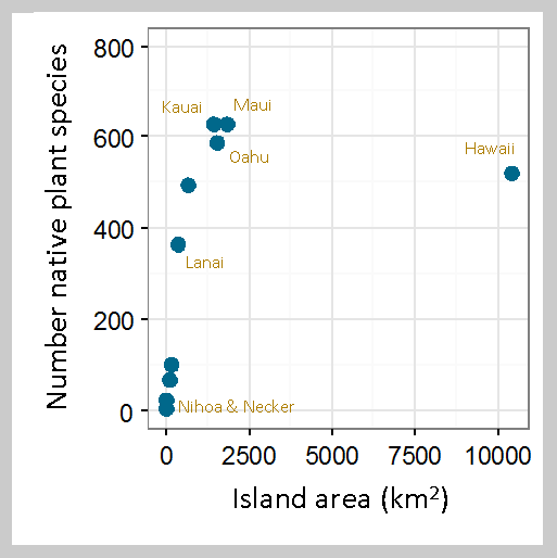
Relationship between number of native plant species and
island area for 10 of the Hawaiian Islands (8 main islands
+ Nihoa + Necker). Data are from Evenhuis and Eldredge
 (2004) and Gustafson et al. (2014). The Big Island is some-
what of an outlier, but this may be reflective of its relative
youth in the island chain.
Isolation has led to high rates of endemism on the Hawaiian Islands. Endemic species are those found in a single location, but no where else. Today Hawaii has an estimated 1207 species of native vascular plants, and a remarkable 88% of them are endemic to the island chain. Some of the individual islands also have local endemics. For instance Kauai has 219 endemic plant species while the younger islands of Oahu and Maui have 140 and 89 endemic respectively.

Isolation has affected which species have been able to reach the islands, but other factors more local to the islands have subsequently influenced the evolution of the successful colonists. Each island in the Hawaiian archipelago has a life cycle of perhaps 5-20 million years from birth to erosion and subsidence to its final days as an atoll. The Big Island is youngest at no more than 1 million years; Kauai and Nihau are the oldest of the major islands at about 6 million years old. So, for some of the earliest colonizing lineages of organisms, their long-term persistence on the archipelago may be due to an ability to hop from island to island. As an older island finally sinks back into the Pacific during its old age, species that can colonize a younger island would persist. Interestingly, many of the species present on the islands today appear to have evolved from colonists that arrived not more than about six million years ago (about when Kaua’i formed) suggesting that island hopping isn’t particularly common.  

The honeycreeper, Vestiaria coccinea, on Acacia koa
(Fabaceae). Photo by Ludovic Hirlimann, CC BY-SA 2.0
license. Source.
The Hawaiian biota is a good example of adaptive radiation, the evolutionary process that results in a large and diverse group of species diverging from a single successful colonizing species. Good examples of adaptive radiation include the silversword plants and the Hawaiian honeycreepers (birds).

Studies of similarities and differences among DNA sequences – a powerful tool to discern relationships among organisms – has also shed some insight into the history of colonization on the islands. For the approximately 1200 native plants currently growing in Hawaii, it is believed that historically there were about 375 separate successful colonizing events. Because colonization and local extinction of species on islands is a continuous process, there were likely more successful colonizations over the geologic history of the islands, but some of those lineages went extinct. We can also speculate that there were probably many more near misses where colonizing seeds or spores arrived on the shores of Hawaii but failed to become established, perhaps because they didn’t arrive in densities high enough to successfully reproduce.

Of the nearly 400 plant colonizations resulting in the contemporary Hawaiian flora, about two thirds have left us with only a single living species. The rest have radiated into groups of related plants. For example, the lobeliad plants now comprise 6 genera and 141 species, each derived from what is believed to be a single colonizing event 13 million years ago. The lobeliad radiation has resulted in a diversity of plant types from succulents to shrubs to trees. Hawaiian radiations have sometimes occurred with little genetic differentiation among the species but much ecological differentiation. An example would be the ohia lehua tree (Metrosideros), which I wrote about in a previous post, a species that varies considerably in size and morphology. In contrast, other radiations can result in much genetic diversity among a group of ecologically-similar species. For instance, a single colonizing event for the genus Cyrtandra has resulted in 59 different endemic species of forest plants, all of which live as forest understory trees or shrubs, and may therefore be pretty similar ecologically.

Isolation and endemism – some of the features that make the Hawaiian biota a remarkable laboratory of evolution – also are coupled with significant threats to biodiversity on the islands. With so much unique biological richness there is much to lose. I’ll discuss threats to Hawaiian conservation in a later post.  

References

Evenhuis NL and Eldredge LG. (eds) 2004. Natural History of Nihoa and Necker Islands. Bishop Museum Press, Honolulu, HI, 220 pg.

Gustafson RJ, Herbst DR, Rundel PW. 2014. Hawaiian Plant Life. Vegetation and Flora. University of Hawaii Press, Honolulu, HI.

Price J. 2009. Hawaiian Islands, Biology. In: Encyclopedia of Islands, Gillespie RG and Clague DA (eds), University of California Press, Berkeley, CA, p.397-404.

10 January 2016

Ice textures


Last weekend, in response to a request for a snow day from the kids, we drove up into the Sierras to Bear Valley near the intersection of Interstate 80 and California route 20. We’ve explored the area several times before, mostly in the winter when it is blanketed in snow. The South Fork of the Yuba River crosses through the area. More a stream than a river at this elevation, its bed is littered with large smooth boulders, each topped with caps of bright snow this time of year.

Umbilicaria sp. on a snow-covered boulder.
Conifers (pines and stately incense cedars), and the grey skeletons of dormant deciduous trees comprise the forest in the area. Where there are gaps in the snow (or on the steeper sides of rocks where snow doesn’t collect), there are vibrant green mosses and a palette of lichens from yellow to chocolate brown species. The brown species (an Umbilicaria I believe) has a peltate form, attaching to the rocks like a very stout mushroom, the margins of the plants unattached. There are black spots on the thalli, varying in size and shape that resemble tar spots. These are the apothecia of the fungi where spores are produced.


Tufts of moss in little ice caves.


The area is generally pretty, but not necessarily remarkable. Winter, with its cover of snow however, brings a freshness that accentuates the mystery of the landscape, rounding the shapes under the blanket, and revealing underlying bedrock or biota here and there. I spent some time looking closely at the ice surfaces, these remarkable in their detail. Here are some close-up photos of different ice shapes and textures.

Reference(s)

Brodo IM, Sharnoff SD, Sharnoff S. 2001. Lichens of North America. Yale University Press, New Haven.

Close-up view of the textured surface of icicles. Each irregular polygon, looking remarkably like a cluster of cells, was on hte order of a few millimeters in size. 


Brittle ice crystals over a bed of moss.