31 July 2016

Snow Lake, Mt. Rainier National Park

Snow lake, the southern end.
Alpine lakes are one of my favorite destinations in the mountain wildernesses of the Pacific states. At higher altitudes the water almost invariably reflects beautiful hues of blue, turquoise, yellow or some other color. The lake margins are usually lined with small wetlands or edge up against beautiful coniferous forests with tall spires of stately trees. Dragonflies and damselflies might dart to and fro while water striders balance on the surface tension of the water. In winter and spring ice blankets the lakes while they quietly sleep through the cold months.

After an evening hike to Comet Falls and a night of camping on the slopes of Mt. Rainier, the next day we set out to see a few other regions of the park. We stopped to see the meadows of lilies (and unexpectedly, the marmots!) at Paradise midday and then drove farther east into the park for a relatively short hike up to Snow Lake. Snow Lake is tucked into a basin at the base of a semi-circular rocky ridge that is part of the Tatoosh Range. The lake is sort of sickle-shaped. After a short jaunt beyond the end of the official trail, one reaches the southern end of the lake where brick orange soils stand out distinctly on the lake bottom.


Map of Mt. Rainier National Park at left (from NPS, 2015), and inset at right with
Snow Lake (from USGS, 1971).


Mt. Rainier from the Snow Lake trail as the sky clears after an early
summer storm.

For the first 24 hours of our visit to the park, Mt. Rainier was shrouded in clouds since a storm that had overtaken the Pacific Northwest that weekend in early July was still lingering. However, the clear skies of summer were returning and on the return hike from Snow Lake back to the trailhead, the clouds shrouding the mountain began to clear and the beaming rugged glaciers of Rainier’s south slopes became visible.

Mt. Rainier is the highest of all the Cascade peaks in Washington, Oregon and California, topping Mt. Shasta by a few hundred feet. Its magnificent slopes culminate in snowfields and cracked glaciers. It is a remarkable beacon in central Washington and I hope to visit again soon to explore all the gems it has to offer: rivers, forests, lakes, waterfalls, and ice!

Reference

Turner M, Gustafson P. 2006. Wildflowers of the Pacific Northwest. Timber Press, Portland, OR

Snow and ice on the southeastern slope of Mt. Rainier. 
White torches of blooming bear grass, Xerophyllum tenax
(Liliaceae).

White rhododendron (Rhododendron albiflorum) at left and avalanche lily
(Erythronium montanum) at right.


18 July 2016

Comet Falls, Mt. Rainier National Park

Last week was my first visit to Mt. Rainier National Park in central Washington. The peak at the center of the park is the highest mountain in the Cascade Range, rising above 14,000 ft. The park boasts lush temperate rainforest and wide river washes fed by rain and glaciers crowning the mountain.

Vine maple, Acer circinatum, the foliage of which is just delightful in the fall.

Waterfalls dot the Rainier map and we headed towards Comet Falls on the southern slope of the mountain the afternoon we arrived at the park. A short distance from the trailhead, the trail passes over one of the tributaries of the Nisqually River that eventually runs into the Nisqually Delta near Olympia. The creek water rushed through a narrow channel of bedrock in a precipitous drop through a small valley making its way down the mountain. After crossing via foot bridge, the trail runs along the eastside of the creek up the slopes of Rainier. The water’s roar was a companion during the hike.

Flowers increased in number and variety gaining elevation up the trail. Among the most common were white six-petaled blooms of Clintonia uniflora, the flowers emerging not far above the ground next to a pair of smooth spatulate leaves (not unlike commercial orchids). Another frequent small ground cover species with white blooms was Cornus unalaschkensis (a small relative of the much larger tree, the dogwood). Yellow asters which I did not observe closely enough to attempt to identify were also common.

Blooms of Cornus unalaschkensis (left) and Clintonia uniflora (right), both common near Comet Falls.

Near Comet Falls there was a small population of the striking avalanche lily, Erythronium montanum, which I would later see in greater abundance in the higher elevation meadows at Paradise farther up the slopes Mt. Rainier. The flowers of this species hang down towards the ground, having six somewhat dishelved white petals that radiate out from a bright yellow center. Paradise also had many individuals of another species of fawn lily, E. grandiflorum (the Glacier lily), similar to the avalanche lily in habit, but with solid yellow flowers. E. montanum is distributed in the Pacific Northwest while E. grandiflorum occurs from British Columbia to California and into the Rocky Mountain west.

Avalanche lily.

Comet Falls.
There were a few Columbia tiger lilies along the trail too. Other booming species were numerous and included Maianthemum racemosum (large false Solomon's seal), Rubus parviflorus (thimbleberry), Rubus spectabilis (salmonberry), Rubus lasiococcus (dwarf bramble), Corallorhiza mertensiana (western coralroot), Phyllodoce empetriformis (pink mountain heather), Dodecatheon sp. (shooting star), and the striking red and yellow ornate flowers of Aquilegia formosa (columbine). The day was damp and cloudy, otherwise resembling conditions I would expect in late winter or fall, except that the presence of flowers and resplendent foliage reminded one that it was indeed summer.

Coralroot (Orchidaceae).

The rainforest at the base of Mt. Rainier is truly lush - one of the greenest forests I've been able to visit. As with most forests in the western Pacific Northwest's, massive conifers dominate the canopy. Cedars and firs were common in the park, and I also noted western hemlock, mountain hemlock, and Douglas fir. The new growth of needles on the tips of the conifer branches was everywhere, the bright green centimeters of vibrant new growth giving accent to the deeper evergreen of the older growth, such a pleasant sight! Lichens hung from the trees in abundance, giving the landscape a depth of age too.

After hiking to Comet Falls, we camped that evening among the beautiful conifers and had one more day to explore Mt. Rainier. The short trip did not give the extensive park due justice of course, but it was enough time to gain a taste for its beauty and to be enticed to return again.

References

Baldwin et al. 2012. The Jepson Manual. Higher Plants of California. 2nd edition. University of California Press, Berkeley, CA.

Turner M, Gustafson P. 2006. Wildflowers of the Pacific Northwest. Timber Press, Portland, OR.

New growth on a small fir tree.


14 July 2016

Oregon caves

Valley leading up to Oregon Caves
National Monument.
The Oregon Caves National Monument lies in the Siskiyou range, a mountainous region in southwest Oregon rich in biodiversity.

Dozens of chambers and tunnels connect the caves in a complex underground maze discovered by Elijah Davidson in 1874 while in pursuit of his dog and a bear that had entered the cave. The caves became a popular attraction; today the National Park Service leads tours of a little over an hour through much of the cave complex.

"Drapery" formed by sheet flow of water though
the cave.
The caves formed over the course of thousands of years as weak carbonic acid slowly dissolved the marble rocks underlying the mountain. The acids formed from the interaction of water with carbon dioxide released from decaying plant matter in the soils overlying the bedrock. The caverns and tunnels vary in size and shape. A very small stream (named the “River Styx”) runs through a part of the cave complex.

Slow mineral deposition over time as water continues to move through the caves has resulted in a variety of interesting forms inside many of the rooms. Dripping water creates forms such as stalagmites and the thin “soda straws” that project from some of the cave ceilings. Flowing sheets of water over rock surfaces form other shapes such as “drapery”. Lights set up by the Park Service help illuminate many of the features for visitors. 

Other cave features: stalagmites, stalactites, and
columns (fused stalagmites + stalagtites).
Drapery is most ornate in the "Paradise Lost" room,
my favorite place along the tour route.
Other reference

National Park Service educational materials

12 July 2016

Crescent City rocky intertidal

The northern-most significant stretch of rocky coastline in California borders the small sleepy town of Crescent City. Last week offered some excellent early morning low tides, so of course part of the Pacific Northwest vacation needed to be scheduled around a few coastal adventures.

Pebble Beach area, Crescent City, exposed at low tide.

The Crescent City coastline consists of a long stretch of boulders (small and large) punctuated with offshore rocks and seastacks. At low tide the intertidal life is rich, especially abundant with red seaweeds. One of the species occurring distinctively here is the small peltate red alga Constantinea simplex. It grows in the low intertidal, mushroom-shaped, along vertical rock faces.

Every visit to the intertidal reveals some treasures - often new species or observations. Some highlights from this low tide excursion:

- a bright orange sea cucumber, unknown species
- a low intertidal pool with a long orange nemerteam worm, some bashful large sculpins, and little orange cup corals (Ballanophyllia elegans)
- abundant Desmarestia munda
- yellow dorid nudibranchs and a few other species

The early morning tide was quite low and the wind and sea were calm - perfect conditions for exploring the low intertidal.

A gray-blue species of sculpin in a shaded shallow intertidal pool.

The orange cup coral, Balanophyllia elegans.

Dermasterias imbricata.

Unidentified sea cucumber.

09 July 2016

Oregon redwoods


According to the fossil record, redwoods once occupied a large expanse of territory across North America. Today they are restricted to a narrow coastal band along the Pacific coast where year-round temperatures are mild.

The modern day range of Sequoia sempervirens stretches from Big Sur in Monterey County, California to just across the California-Oregon border. At the southern end of the range, the trees tend to be shorter, tucked away inside steep valleys cut into the Big Sur coastline. They may survive courtesy of tongues of fog that roll in from the cool Pacific into the coastal valleys, while finding the dryer warm hillsides too inhospitable. Towards the northern end of the range in Humboldt and Del Norte counties, the redwoods reach their most favorable conditions, at least as evidenced by the size of the trees. In Tall Trees Grove in Redwood National Park in northern California, for example, several contenders for the world's tallest tree thrive near Redwood Creek.

Though I have spent much time among the redwoods throughout much of their range, until this week I had never seen the northernmost trees in the southwest corner of Oregon. The occasion was the first leg of a Pacific Northwest vacation in northwestern California and southeast Oregon. After an early morning exploration of rocky tidepools in Crescent City, I thought it would be an opportune time to make a detour to find the redwoods before heading to Oregon Caves National Monument (hopefully more on these adventures in later posts).

After crossing into Oregon heading north on US101, one heads east to follow the course of the Winchuck River for a few miles and then turns off onto a narrow one-lane road that winds into the western reaches of the Rogue River Siskiyou National Forest. About 2-2.5 miles into the road, the distinctive clusters of redwoods begin to appear among other conifers and at 4 miles the road ends and the Oregon redwood trail begins.

Redwood sorrel and wild ginger.


Maianthemum sp. 
The old growth forest hosts the typical consortium of understory species in Sequoia forests: carpets of redwood sorrel, tufts of sword ferns, and rhododendrons. I also observed huckleberry bushes, wild ginger, and a few orange tiger lilies.

Reference

Turner M, Gustafson P. 2006. Wildflowers of the Pacific Northwest. Timber Press, Portland, OR.

05 June 2016

Granite Chief Wilderness

Lake and stream in the Granite Chief Wilderness.
The Granite Chief is the northern-most wilderness of the high Sierra, located west of Lake Tahoe and north of Desolation Wilderness. Up to about 7000 feet, most of the snow in this part of the Sierra has now melted. However, at in the Five Lakes basin to which I hiked last weekend (about 7000 ft elevation), most of the ground was still covered with snow, hardened presumably by repeated melting and refreezing. The firm ground made for easy hiking, though once up in the vicinity of the lakes, I lost much sense of where the existing trails were supposed to be.

The lakes were mostly frozen, but thawing. At the third lake I arrived at a thin transparent sheet of ice like glass was just receding from the edge of the shore. Water flowed out of this lake and fed an active stream that rumbled through naked deciduous trees down into a valley.

Phlox, Granite Chief Wilderness.


Without discernible trails, I didn’t venture far into the wilderness, but did hike up a ridge of exposed granite boulders that overlooked the lake basin. Here little carpets of Phlox were abundant. The flowers amass in dense aggregations of white to pinkish 5-lobed disks, each corolla of petals fused towards the base, protecting a few partly recessed bright orange stamens. There were also orange-red paintbrushes and yellow stalks of wallflowers blooming too, but Phlox was most abundant.

I made an effort to identify the common conifer species in the area; learning the diverse conifer flora of the western US is one of my long-term goals. By far, pines and firs dominated the landscape. I felt moderately confident identifying western white pine (Pinus monticola), lodgepole pine (Pinus contorta), California white fir (Abies concolor), and red fir (Abies magnifica). However, distinguishing the fir species was sometimes a challenge, particularly when the trees were small. I also found a mountain hemlock (Tsuga mertensiana; this species is common in the Three Sisters Wilderness of Oregon) and a lone gnarly Sierra juniper (Juniperus grandis), an old sentinel on the granite ridge overlooking the lake.

Juniperus grandis.


Reference

Kauffmann ME. 2013. Conifers of the Pacific Slope. Backcountry Press, Kneeland, CA.


31 May 2016

Yosemite IV: Glacier Point

Looking southwest into Tenaya Canyon
with Yosemite Valley in the distance.
I took a quick weekend trip to Yosemite this month. The waterfalls were full; the new foliage on hardwood trees was bursting forth like lime green jewels. There were two new destinations on this trip for me: a hike into Yosemite wilderness on the northwest wall of Tenaya Canyon and a drive to Glacier Point on the southern rim of Yosemite Valley. Both afforded incredible views of Half Dome, Tenaya Canyon, Yosemite falls, and the other gems lying at the heart of the park.

From atop Glacier Point it was easy to see how crowded and developed Yosemite Valley has become. Meadows, forests and the sinuous Merced River still occupy most of the valley floor, but the roads and clusters of cars are in plain view from above. John Muir described the view as follows: “From Glacier Point you look down 3000 feet over the edge of its sheer face into the meadows and groves and innumerable yellow pine spires, with the meandering river sparkling and spangling through the midst of them. Across the Valley a great telling view is presented of the Royal Arches, North Dome, Indian Canyon, Three Brothers and El Capitan, with the dome-paved basin of Yosemite Creek and Mount Hoffman in the background. To the eastward, the Half Dome close beside you looking higher and more wonderful than ever; southeastward the Starr King, girdled with silver firs, and the spacious garden-like basin of the Illilouette and its deeply sculptured fountain peaks, called ‘The Merced Group’; and beyond all, marshaled along the eastern horizon, the icy summits on the axis of the range and broad swaths of forest growing on ancient moraines, while the Nevada, Vernal and Yosemite Falls are not only full in sight but are distinctly heard as if one were standing beside them in their spray.” – The Yosemite, 1912. 

View from Glacier Point. Tenaya Canyon entering Yosemite Valley in the foreground. Half Dome to the right.
Left: Vernal Falls. Right: Yosemite Falls.

22 May 2016

Mill Creek at Big Sur

Macrocystis pyrifera (giant kelp) growing in a shallow pool in the intertidal.
Big Sur is one of my favorite places along the northeastern Pacific coast. Here the Santa Lucia Range presses against the Pacific coast, forming rugged rocky shoreline next to steeply cut valleys filled with redwoods and hillside slopes of chaparral and grassland.  

Much of the area is designated as California State Parks or National Forest (including wilderness) land. Big Sur has the usual California problems of invasive species, but the area has historically endured relatively little development. Tourists stream in along Highway 1 (in seemingly greater volume), particularly from the Monterey Peninsula, but much of the shoreline and coast range is too rugged for heavy human use.

I have a few favorite intertidal locations in Big Sur that I’ve visited intermittently over the years to tidepool, photograph marine life, or just collect seaweeds. Actually, quite a bit of the coastline is relatively inaccessible because of its steep topography, or for other reasons. For this month’s early morning spring tides, I visited Mill Creek on the southern Big Sur coast. Because of the early morning tide, I camped Sunday night at Plaskett Creek, and then Monday morning was lucky to have Mill Creek’s rocky stretch of coastline to myself.

Sea stars at Mill Creek, including Henricia leviuscula (center) and two examples of what may be
Leptasterias, a species complex of 6-armed Pacific coast stars. 

Desmarestia munda, acid (!) "kelp".
Excellent low tides notwithstanding, large swells offshore can keep the low intertidal relatively inaccessible for those wishing to stay relatively dry, but one solution to this is to don a wetsuit, at least up to one’s stomach, and make way into the low intertidal and the deeper intertidal pools. With some decent off-shore waves, this trip benefited from that method and I was able to access the deeper pools and photograph quite a few marine treasures with my underwater camera.

Mill Creek has a good mix of seaweeds (large brown seaweeds, foliose and finely-branched red algae, and some green algal species), seagrass (Phyllospadix) and invertebrates (anemones, seastars, mussels, etc.) – an example of a high diversity, less disturbed stretch of central California coastline. The substrate here is a field of large boulders, a cobble beach, and larger bedrocks with areas of coarse sand. The boulders tend to be rather large and are covered generously with algae and invertebrates.

Small seastars were common this month. Many were the whitish Leptasterias spp. (a six armed star typically a few cm across), but some were also juveniles of larger species. These new recruits perhaps represent local evidence of the reported rebound in sea star populations after the wasting disease phenomenon that led to a crash in west coast sea star populations in the last couple years.

Brightly-colored nudibranchs were also abundant and I spent some time photographing these beautiful animals underwater in the shallow pools. I observed at least 5 to 6 species including Okenia rosacea, which has seemed pretty abundant across the central to northern California coast over the last year. Yellow dorids were the most common on this trip ato Mill Creek. 

Two Mill Creek nudibranchs. Left: Triopha catalinae. Right: Dendrodoris fulva or Doriopsilla albopunctata.

Hermissenda crassicornis on articulated red coralline algae.


References

Behrens DW. 1991. Pacific Coast Nudibranchs. Sea Challengers, Monterey, CA.

Morris RH, Abbott DP, Haderlie EC. 1980. Intertidal Invertebrates of California. Stanford University Press, Standford, CA.


24 April 2016

Incredible plants: Pleurophycus gardneri

Pleurophycus gardneri sporophyte with Laminaria
setchellii
and other seaweeds on low intertidal rocks
at Glass Beach, Fort Bragg, CA, April 2016.
I came across a rare treat tidepooling earlier this month at Glass Beach in Mendocino CountyPleurophycus gardneri!

Pleurophycus is a moderately-sized kelp, consisting of a single photosynthetic blade at the end of a stipe than can be up to a half meter long (Abbott and Hollenberg 1976). Like other kelps, it is attached to the rocks with a holdfast, a structure that resembles roots. Pleurophycus lacks branches or the pneumatocysts (floats) that are present in some other kelp species. Its distinguishing feature for identification in the field is the presence of a wide midrib on the blade with a ruffled blade surface immediately next to each edge of the midrib. The species is perennial and deciduous with blades dying back each year (Germann 1986, Lindeberg & Lindstrom 2010).

The species is distributed from central California into Alaska (Silva 2009) but in my experience it is uncommon in California, particularly in the intertidal zone where I stumbled across a single individual in a narrow channel.

Western phycologists first collected the species from San Juan and Whidbey Islands in Washington state and from Alaska in the late 1890s (Silva 2009). Setchell and Gardner (1925) described its distribution from Alaska to Coos Bay, Oregon. Decades later a large population was found in the low intertidal at Ft. Bragg (Kjeldsen 1972) and the species was later discovered to occur subtidally off of San Luis Obispo County and Big Sur (Silva 2009).

For me, finds like this make an early morning rise to catch the spring low tides well worth it. In fact, though I am not naturally a morning person, I can’t say I ever regret a 4 or 5 AM wake up for a low tide adventure along the coast. During intertidal exploration I often find something new, but even when I do not, my curiosity and love of natural history is re-invigorated by the cool salty air and the beauty and complexity of the rocky shores of the Pacific.

References

Abbott IA, Hollenberg GJ. 1976. Marine Algae of California. Stanford University Press, Stanford, CA.

Germann I. 1986. Growth phenology of Pleurophycus gardneri (Phaeophyceae, Laminariales), a deciduous kelp of the northeast Pacific. Canadian J Botany 64:2538-2547.

Kjeldsen CK. 1972. Pleurophycis gardneri Setchell & Saunders, a new alga for northern California. Madroño 21:416.

Lindeberg MR, Lindstrom SC. 2010. Field Guide to Seaweeds ofAlaska. Alaska Sea Grant College Program, Univ. Alaska, Fairbanks.

Setchell WA, Gardner NL. 1925. The Marine Algae of the Pacific Coast of North America. Part III Melanophyceae. UC Publications in Botany 8:383-898.

Silva PC. 2009. Historical, nomenclatural, and distributional notes on two Pacific coast kelps: Lessoniopsis littoralis and Pleurophycus gardneri (Phaeophyceae, Laminariales, Alariaceae). Madroño 56:112-117.

18 April 2016

Adaptations of the Cactaceae

Cacti are iconic plants of desert environments. These succulent plants occur in the family Cactaceae. There are about 1800 species worldwide in the family, grouped into 125 genera. The family is endemic to North and South America, distributed from southern Argentina to Canada. One additional species occurs in western Africa and some of the islands of the Indian Ocean.

As a group, the Cactaceae are believed to have evolved in South America about 65 million years ago (around the same time as the extinction of dinosaurs), though molecular data suggest a more recent origin of about 30 million years. 65 mya, South America was warm and dry, but disconnected from North America. Cacti spread north, using Cuba and other islands as dispersal stepping stones, arriving in Mexico about 36 million years ago. In North America, the western deserts expanded about 2-5 million years ago with further radiation of cactus species.

The beavertail cactus, Opuntia basilaris. Left: Plant with flower buds from Death Valley National Park, March 2016.
Right: Plant from Joshua Tree National Park, February 2012.

Cacti are excellent plant examples of structural adaptations to meet unique environmental circumstances. The fleshy part of a cactus is actually the stem. In many species the stem is succulent, allowing for water storage in the dry habitats where they live. Water is stored in the stem's parenchyma cells. Stems have additional adaptations to minimize water loss such as the presence of a thick waxy outer cuticle and stomata that are sunken. Individuals can withstand water loss of up to 70-95% because the tissues have so much water storage potential. The longitudinal ribs present in some species are capable of expanding and contracting like an accordion without damaging the protective cuticle as water content in the plant varies.

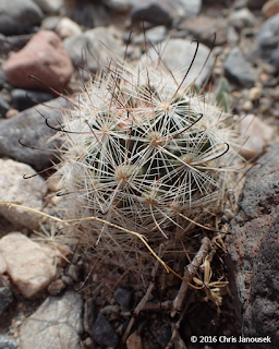
Mammillaria tetracistra from Panamint Valley in
Death Valley National Park, March 2016. The
black spines on this species are hooked.
The spines of cacti are actually modified leaves. They are non-photosynthetic but have several other functions. The most obvious is defense against herbivores. Spines can also help a cactus acquire water when dew condenses on them, or help shade the plant. The spines may assist with dispersal of segments of the plant when they are caught in the fur of animals and transported around. Some "gland spines" produce nectar which help the plant attract pollinators.

Cacti also couple physiological adaptations with anatomical and structural modifications to deal with arid growing conditions. Plants acquire carbon dioxide (needed to build sugars and other organic molecules) from the air through their stomata, but having stomata open in a hot dry environment makes plants susceptible to water loss. One way to acquire CO2 but minimize water loss is through CAM photosynthesis, a variation of C3 photosynthesis present in most other plants. In CAM species the stomata remain closed during the day, but then open at night to acquire CO2 when the potential for water loss is reduced. Carbon dioxide captured at night is temporarily stored as an acid in the cells and later used to build sugars.

According to the recent Jepson manual, California has 37 native species of cacti. On my trip to Death Valley last month, I observed at least five of those species. Two species were particularly common: the beavertail cactus and the clustered barrel cactus. The beaver tail belongs to the genus Opuntia, plants which are also known as prickly pears. Prickly pear stems grow as segments, appearing as upside down tear-shaped fleshy leaves. In early March flower buds were forming on the beaver tails (O. basilaris) but I was too early to see open flowers.

Examples of Echinocactus polycephalus from Death Valley National Park. Incidentally, the Greek
etymology of this species name is fun: 'spiny cactus of many heads'.

Another relatively common cactus at Death Valley was the cholla, a group of cacti classified in the genus Cylindropuntia. I was first introduced to chollas as an undergraduate student when my marine ecology field class traveled from Santa Cruz to northern Mexico through the Arizona desert. We were warned to avoid touching these plants because of their menacing barbed spines which can be difficult to remove from the skin. Chollas have cylindrical stems that also occur in segments like the prickly pears. The small stem segments break off and lay on the desert floor. California has 10 species of cholla and I've also observed specimens of this genus in Joshua Tree National Park, northern Arizona, and Sonora Mexico.

Cholla from Joshua Tree National Park, Feb 2012. These plants are so densley covered  in light-colored spines
that one can hardly see the green stem. It is possible that the dense covering of spines helps reduce water
 loss from the plant.

References

Baldwin BG, Goldman DH, Keil DJ, Patterson R, Rosatti TJ, Wilken DH. 2012. The Jepson Manual. Vascular Plants of California. 2nd ed., University of California Press, Berkeley, CA.

Ingram S. 2008. Cacti, agaves, and yuccas of California and Nevada. Cachuma Press, Los Olivos, CA.

Zomlefer WB 1999. Guide to Flowering Plant Families. The University of North Carolina Press, Chapel Hill, NC.


20 March 2016

Death Valley blooms

Geraea canescens (Desert Gold), the most common
wildflower species at low elevations in Death Valley
National Park. Photo taken at Devil's Cornfield.
Deserts present formidable challenges for plants and animals to craft an existence. Access to water is chief among these challenges. Not only must desert organisms be tolerant of lack of water for many months of the year, they must also be capable of capitalizing on the rare and unpredictable opportunities to acquire water when the rains do come.

Death Valley is the hottest and driest location in North America. Lying just east of the Sierra Nevada in eastern California and western Nevada, it is part of the Mojave Desert. The Sierras catch most of the precipitation in the storms that roll in from the Pacific bound for California. Little rain or snow makes it past the formidable granite blockade of the Sierras. One of the largest national parks in the US encompasses Death Valley, along with part of Panamint Valley and the Panamint and Amargosa mountain ranges. The vast majority of Death Valley National Park is designated wilderness area – rugged terrain without roads or human development. 

But rain does come to the desert occasionally. On 18 October 2015, a significant storm drenched the valley, setting the stage for the burst of wildflower color that we are now observing in early 2016. That heavy rainfall event, totaling about as much rain in one day as the valley averages in a year, signaled to a dormant seed bank of desert annuals that this was their chance to germinate and complete another generation. Months later, the wildflower bloom began.

Left: Atrichoseris platyphylla, or the "Gravel Ghost". The flowers (technically inflorescences since this species is
an aster) are a few centimeters in diameter and they sit atop long spindly stems. Photo from Scotty Castle Rd.
Right: Mohavea from Panamint Valley.

Phacelia sp. The bold blooms of this species
were particularly common along roadsides.
Being aware of the current El Niño in the Pacific, I had already planned a trip to Death Valley months ago with a hope that the floral display this spring would be impressive. However, when I started to hear media reports in late February of the “superbloom” sweeping Death Valley, I decided to move my visit up a few weeks on the calendar. With a dry and warm February in northern California, it seemed that spring had really come early to California this year and I didn’t want to miss my chance!

Most of the flowers during my trip in the first week of March could be seen from below sea-level to about 3000 ft elevation, including in Death Valley and Panamint Valley. Above 3000 feet, flowers could be observed in a few locations – including the flowering Joshua Trees (Yucca brevifolia) along Wildrose Road and Indian paintbrushes (Castilleja) and others near Daylight Pass along the California-Nevada border. A report from the park in late February suggested that the densest fields of flowers could be found in the Badwater Road area, a part of the park that I did not visit. However, there were relatively dense concentrations of yellow blooms of Desert Gold (Geraea canescens) near Furnace Creek and Salt Creek.

The beautiful Eremalche rotundifolia (Malvaceae).


My favorite species in bloom was a small mallow, Eremalche rotundifolia, commonly called the “desert five-spot”. The delicate pink petals of this flower form a cup, so one has to peer inside from the top to see the rest of the flower. From that perspective, one can see that each petal has a dark red splotch at its base. The desert five spot was not particularly common in the areas I visited, but it occurred in both Panamint Valley and Death Valley between Furnace Creek and Stove-pipe wells. Another mallow, also with very showy flowers hosting peach-colored petals (the Apricot Mallow), appeared to be even more rare; I only observed two plants during the two day trip. 

Sphaeralcea ambigua, Apricot Mallow.
Deserts host their own beauty – from clear night skies to fascinating geological landscapes to bright bursts of wildflower color. The paradox of life is transparent in the desert – a place where harshness and beauty plainly co-exist.

References

Baldwin GB et al. (ed). 2012. The Jepson Manual. 2nd ed. University of California Press, Berkeley, CA.

Milliard D. 2016. Wildflower update 2016. National Park Service website.

Munz PA. 1962. California Desert Wildflowers. University of California Press, Berkeley, CA.

National Park Service. 2016. Death Valley National Park Visitor's Guide, Winter/Spring 2016.


Left: Creosote bush (Larrea tridentata), the most common larger shrub in Death Valley. Many of the plants were
in bloom. Center and right: Two other unidentified species.
Mimulus bigelovii. Plants bearing these flowers were typically
very short in stature. One population of this species grows in a
small canyon at the base of hills near Big Pine Rd. 
A Joshua Tree, Yucca brevifolia, in bloom. I noted two populations of
Joshua trees in and around Death Valley National Park, both growing at
elevations in excess of about 4000 ft. This tree was in a population
along Wildrose Rd.
Chylismia brevipes was one of the most common blooming species
I saw in early March. The petals are often solid yellow, but sometimes
have red spots as in this example from along Big Pine Road at the
north end of the park.