30 June 2017

Boiler Bay

Boiler Bay rocky intertidal (north of the
small sandy cove). Is this the boiler from
which the site gained its name?
Although I lived in Oregon for several years (including a year and a half on the coast), I did less exploration of the rocky intertidal during those years than I would typically do during the same time span living in California. Oregon’s exceptionally scenic coastline features dunes, sandy beaches, rocky shores, and numerous estuaries. It was the latter ecosystem that I explored the most, working up and down the coast to research Oregon’s tidal wetlands.

For my last rocky shore visit of this month’s spring tide series, I wandered about the shores of Boiler Bay, a small cove north of Depot Bay on the central Oregon coast. A short steep trail leads to a small sandy beach at the head of the cove, with rocky intertidal benches to the north and south. Boiler Bay is apparently a well studied area, as evidenced by bolts and other obvious scientific interventions along the shoreline. I believe it may be a study site for Bruce Menge’s long-term study of Oregon’s rocky intertidal communities. South of the cove there was even a collection of dozens of small pools cut into the bedrock, too uniform in size and location to not be the hard work of a former research project, perhaps the sweat and tears of a graduate student dissertation from years past.


Various evidences of scientific interventions to study the rocky shore at Boiler Bay.

After observing for a few hours, an obvious ecological story of the Boiler Bay rocky intertidal is that of plant versus herbivore. Along the rocky benches south of the cove, large areas – dominated by purple urchins (Stronglyocentrotus purpuratus) in the thousands – are clearly claimed by herbivore. I don’t ever recall seeing intertidal urchins in such high densities anywhere else I’ve wandered on the west coast. The power of the urchins to shape this segment of coastline has even formed a geologic imprint: many of the urchins rest in small cavities carved into the rocks, the gradual work of spines that have eroded the mudstone over however many generations.

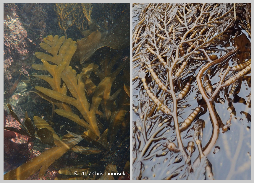
Small bull kelp in a tide pool at Boiler Bay.
Large fleshy seaweeds are prolific in other areas, away from the urchins. This means they are more abundant at higher shoreline elevations where urchins probably can’t tolerate the prolonged exposure to air, or in lower tidal areas where urchins perhaps aren’t able to gain high densities for other reasons. The large kelp Saccharina sessile grows in abundance higher on the shore out of reach of the grazing hordes, while Alaria marginata and Nereocystis luetkeana (bull kelp) occur in low intertidal pools or other fortuitous havens of safety. The elegant bull kelps typically occurred in aggregations as small to medium plants that will never reach the much larger stature that plants forming thick forests offshore will attain.

There is one notable kelp species that seems more impervious to the grazing menace of the purple urchins: Costaria costata. Having various common names like seersucker or five ribbed kelp, this striking species consists of a single, highly ruffled brown blade growing out of the base of the plant. Within the extensive urchin enclaves of the low intertidal at Boiler Bay, Costaria was present in remarkable abundance. The plants were typically small, and often tattered, but it was basically the only large seaweed common in the “barrens” where the purple urchins ruled.

Costaria costata sporophytes with abundant purple urchins in the low intertidal zone.

Costaria’s secret may lie in part from being an annual species. With quick growth in the spring, some plants may escape herbivory long enough to produce spores to continue the life cycle. Another possibility is that Costaria is a less preferred food source for the hungry urchins. Alternatively, competition might limit Costaria to urchin-dominated areas. In areas where perennial kelps like Laminaria setchellii or Pterygophora californica are present, perhaps the annual Costaria seldom gains the upper hand in competition with the established plants for space and light.

One important ecological force structuring coastal rocky shore ecosystems in Oregon however, lays obscured in history. Before being hunted severely to near extinction, the sea otter of the northeastern Pacific was a key predator of urchins, keeping grazers in check and promoting kelp abundance. This example of a marine “trophic cascade” was described decades ago in work done by ecologist Jim Estes. In a trophic cascade, healthy predator populations keep herbivore abundance low which favors primary producer populations. Today however, sea otters are essentially absent from Oregon’s coastline, so a key link in the historic web of connected coastal species is missing. Are Oregon urchin populations much higher today than they were several hundred years ago when otters were present? Whatever combination of mechanisms underlies the spatial patterns of distribution of urchins and Costaria, the observations suggest an interesting story.
Sponge in a low intertidal pool.

Large red urchins, Stronglyocentrotus franciscanus, were also relatively common at Boiler Bay, though their numbers are dwarfed by their smaller purple cousins. These grazers tended to be underwater (e.g., in pools), perhaps less tolerant of being exposed to air than their congener. Other intertidal invertebrates included beds of mussels, chitons, a few species of sea stars, and aggregating and solitary anemones. I observed no nudibranchs, but did see a few bright yellow sponges in the low intertidal and a lovely crab which I may try to identify when I am back in the company of a good reference book. 


Low intertidal crab at Boiler Bay.


27 June 2017

Grayback

Sucker Creek in southwestern Oregon.
I’m toward the beginning of a road tip through the northwest and the first days of the route have been similar to our trip last year about this time of year: tidepooling along the northern California coast and then a jaunt inland into southwestern Oregon near Oregon Caves NM.

Sunday night was spent at a lovely US Forest Service campground near Sucker Creek. The cool temperatures of the northern California coast were broken by a warm afternoon as we headed inland into Oregon. But in the early evening clouds grew to fill the forested sky and the low rumble of thunder could be heard in the distance. The thunder became more imminent and then rains came followed by a few minutes of hail. Rain (or hail), should realistically be expected at almost any time in Oregon. It is the elixir sustaining the evergreen brilliance of western Oregon.


Hail!
The storm was accompanied for a brief period of strong winds too, dislodging Douglas fir cones onto the campsite, swaying the trees above, and suspending sprays of conifer leaves in the air near the forest canopy. I was exhausted from a busy work week followed by two early mornings of intertidal work along the California coast and I fell asleep uncharacteristically early in the evening after the peak of the storm passed through. In the morning, the sky was blue and rays of the sun passed beams through the forest illuminating the humid summer air.

Five-fingered ferns (Adiantum aeluticum) grew on the far back of Sucker Creek across from the campsite. The water moved swiftly, apparently in greater volume than last year which was a drought year for the west. I saw no tiger lilies from afar as I had seen last year, but columbines grew near the base of a thin waterfall on the far bank. This location was impressed into my mind because of the fortunate circumstance of photographing a swallowtail butterfly feeding off the nectar of the lilies, two gorgeous organisms together! With the waterfall and attractive organisms, I recall that this little spot also had an outcropping of serpentine rock, a delightful occurrence of several of my favorites.


11 June 2017

Abalones at Shelter Cove

As populated as California is, there are still remote areas that have relatively fewer people, especially in the northern half of the state. Opportunities to get away are protected behind the hassles of winding mountain roads or the labor of long trails. One has to simply be willing to get up earlier or hike farther, and the crowds can be left behind. However even with such effort expended, in California it is rare to be able to completely leave all other people behind. I know of a very small number of coastal areas where this is more or less possible, but I’d rather not name them.

Rocky intertidal at Shelter Cove, looking south.
One less crowded (though by no means secretive) stretch of California coastline is Shelter Cove at the southern end of Humboldt County. It is a small coastal community at the terminus of a torturous narrow road leading from US101 through the coastal redwood “curtain”. To the north and south of Shelter Cove are long stretches of more remote coastline – the King Range area – which I hope to explore more by trail some day.

I was fortunate to catch several of the exceptionally low tides over the Memorial Day weekend. My last stop of three consecutive days was Shelter Cove. It was a lovely morning of tidepooling, marking my return after some 14 years to this site. My first and only other visit was an intertidal adventure memorable in large degree because of a flooded camera. We drove south along US101, leaving the early morning rain in Eureka, and then turned toward the coast. The rain gave way clouds and then eventually to an increasingly sunny morning.

For the coastal explorer, Shelter Cove presents a few kilometers of compelling habitat. I returned to the southern-most stretch of coastline, just north of the cove proper, the approximate site of the deceased camera. Low tide exposed boulders, cobbles, and a meadow of small brown stipitate kelps. Here the usual low tide kelp dominant Laminaria setchellii, was joined by Pterygophora californica in about equal abundance. Some of the plants were tattered from the abuse of surf or herbivores.

Large brown seaweeds in the low intertidal at Shelter Cove. Laminaria setchellii (left)
and Stephanocystis osmundacea (right).

Pterygophora is a species I typically associate with subtidal kelp forests. Curiously, however it was common in the low intertidal zone at all three sites I visited in northern California for the long weekend. Another very common large brown species at Shelter Cove was Stephanocystis osmundacea (older name = Cystoseira osmundacea). Attached by a tough, almost woody base, this species is large enough to form underwater canopies like several of the kelps, but it is classified in a different order of brown seaweeds. The basal portion of the plant consists of flat pinnately-divided fronds. The top portion is more wiry in morphology and contains the most attractive part of the plant in my opinion: the concatenated pneumatocysts that look like strings of brown pearls, and which function by virtue of holding gases to keep the upper part of the plant afloat.

Stephanocystis osmundacea at Shelter Cove. Basal fronds underwater (left) and
apical portion of the plant with pneumatocysts (right).

The low intertidal into the shallow subtidal was littered with small cobbles which were covered in crustose coralline algae, brightening the substrate with pink and white. Because of their smaller size, the cobbles are likely unstable during periods of high surf, impeding any hope of long-term residence by fleshy seaweeds. The slow-growing, calcium carbonate-encrusted coralline algae however, seemed to find this sufficiently acceptable habitat.

Underwater branching and encrusting coralline algae at Shelter Cove.

In the low intertidal, a little above the water line, I soon discovered my first abalones of the day tucked into a tiny rocky ledge. There were nine individuals! In my experience, it is relatively unusual to find more than a few scattered individual abalones on any stretch of California coastline, but by the end of my wanderings that morning, I ended up counting some 77 or so over about 200 m of coastline.

Red abalones, Haliotis rufescens, in the intertidal at Shelter Cove.


The abalone hunters are well aware of the bounty present at Shelter Cove too. In fact, as I was likely the lone (bipedal) seaweed enthusiast at Shelter Cove that morning, I was quite outnumbered by divers wading in the shallow subtidal with wetsuits and donut-shaped floats looking for specimens of legal size. I have personally never tried the apparent delicacy of the expertly-prepared abalone. Despite my deep enjoyment of many things oceanic, I have generally never been too particularly interested in seafood.

Abalones are even more dedicated seaweed enthusiasts than me, feeding on kelp or other species of macroalgae. The slow-moving mollusks clamp down on a bit of sea salad as it floats by. For some species of abalone, an animal’s choice of seaweeds to dine on can be reflected in shell color. Consumption of red seaweeds, for instance, will lend the shell a reddish color from the pigment rufescine.

Abalones are gastropod mollusks, related to snails, limpets, and slugs. They occur worldwide, but attain their greatest size in the Pacific basin. Along the Pacific coast of North America there are seven species: red, black, green, pink, pinto, white, and flat.

Of these species, red abalones (Haliotis rufescens) seem to be the most common in northern California. It was this species I noted in relatively high abundance at Shelter Cove. The visible part of the tough muscular foot is black in color, protected underneath a generally pinkish to reddish pearly shell. A row of perforations near the margin of the shell are the site where gills expel water. In California this is the only species that can be fished, and even then, it can only be taken north of San Francisco, and by free diving, and during certain periods.

The only other abalone species I definitively recall seeing in the rocky intertidal is the black, H. cracherodii. I found a rare cluster of these organisms while tidepooling at Carmel Pt. south of Monterey in December of last year. Like some of the reds at Shelter Cove, these animals were wedged in a rock crevice. Black abalones occur from Mendocino County south to Baja California and can live at higher elevation in the intertidal than other species.

Black abalones, Haliotis cracherodii, in the intertidal at Carmel Pt.,
Monterey Co., CA, Dec 2016.


Unfortunately abalones tell a tale of coastal resource exploitation. After 20 years of tidepooling throughout California, my experience suggests it is relatively rare to see abalone in any significant number in the intertidal zone. Yet this was not always the case. Older photos from southern California decades ago show intertidal abalones in incredible abundance, covering much of the surface of the rock and crawling on top of each other! Overfishing, El Niño, and disease appear to have contributed to the severe loss of these important coastal ecosystem members. With declining numbers, rehabilitation of populations is now the key focus for these organisms.

Not all west coast species are equally threatened. While a fishery still exists for reds, white abalones (H. sorenseni) are so rare in the wild that they are in danger of going extinct. This species lives in southern California and Baja California in deeper waters. Whites were the first species of marine invertebrate to gain a federal listing of endangered in the United States. NOAA estimates that several thousand individuals still exist in the wild, but these adults may be the last cohort of a species at the edge of extinction. Mating success is dependent in adults being close enough to each other that sperm and eggs have a chance of meeting.

A group of researchers housed at UC Davis’s Bodega Marine Laboratory, are working hard to help recover this species. Black abalones are also federally endangered, having experienced a severe population decline in the last few decades.

References

Calif. Dept Fish Wildlife. No date. White Abalone Recovery Project.

Morris RH, Abbott DP, Haderlie EC. 1980. Intertidal Invertebrates of California. Stanford University Press, Stanford, CA.


NOAA Fisheries. 2016. White Abalone (Haliotis sorenseni).

Ricketts EF, Calvin J, Hedgpeth, Phillips DW. 1985. Between Pacific Tides. 5th ed. Stanford University Press, Stanford, CA.

Dermasterias imbricata at Shelter Cove.
Stephanocystis osmundacea from below.

21 May 2017

New seaweed finds in central California

At the end of my trip through the southwest, I shifted from National Parks and lizards and desert wildflowers to marine life of the central California coast. At tidepooling stops in Cambria and northern Santa Cruz County, I encountered two new-to-me brown seaweed species, exciting discoveries punctuating my long-term study of natural history and biogeography along the west coast.

The first new species was a high intertidal species of rockweed at Cambria in San Luis Obispo County. Rockweeds are a family of brown seaweeds in the order Fucales. Many coastal visitors (enthusiastic about slimy seaweeds or not) have likely seen these organisms since they tend to be common on rocky shorelines and live high in the intertidal zone where a good low tide isn’t necessary to leave them exposed.

Until recently, five rockweed species were recognized along the California coast (Abbott and Hollenberg 1976; Gabrielson et al. 2004; Gabrielson et al. 2012). These species are Fucus distichus, Silvetia compressa, Hesperphycus californicus, Pelvetiopsis limitata, and Pelvetiopsis arborescens. There have been several changes to the scientific names of the California rockweeds since the publication of the landmark book on California seaweeds (Marine Algae of California; Abbott and Hollenberg 1976), so I’ve included the older Latin names in the table below.


Wandering the west coast, I have seen all five of these species at various points, the rarest being P. arborescens which is only found in the vicinity of Monterey. My visit to Cambria last month was my first encounter with the sixth rockweed species, since it was newly described in the scientific literature in a paper earlier this year (Neiva et al. 2017). Maybe I have seen it before without recognizing it as a distinct species.

Two common rockweed species in California: Fucus distichus (left; Carmel Pt., Monterey Co., 2014) and Silvetia compressa (right; Scott Creek, Santa Cruz Co., 2007).

Traditionally species have been described based on their morphology, but increasingly molecular signatures are complementing, and even upending, traditional concepts of differences between species. Neiva and colleagues examined mitochondrial DNA from Pelvetiopsis and Hesperophycus, identifying a new species of Pelvetiopsis: P. hybrida.

Neiva et al.’s study resulted in some other interesting findings. First, they found evidence that P. hybrida originated because of a relatively recent hybridization event between Hesperophycus californicus and Pelvetiopsis arborescens. Up until this study, the authors note, this type of hybridization (allopolyploidy) has probably never been documented before in brown seaweeds. Polyploidy refers to chromosome multiplication inside the nucleus during a hybridization event (for instance, a hybrid progeny has twice the number of chromosomes as its parents). Allopolyploidy occurs when the two parents are from different species.

Second, the researchers confirmed that P. arborescens is a distinct species genetically, and suggested that its restricted range indicates it is a climatic relict. Finally, they found that the evidence didn’t favor placing Hesperophycus on its own separate branch on the evolutionary tree. Instead this genus seemed to stem from within the Pelvetiopsis branch, meaning that it should be renamed to be a part of that group. Hesperophycus californicus was this renamed to P. californicus in the study. 

Pelvetiopsis spp. along the US west coast. Clockwise from upper left: P. limitata (Dillon Beach, Marin Co., CA, 2008), P. californicus (Cambria, San Luis Obispo Co., 2017), P. hybrida (Cambria, 2017) and P. arborescens (Carmel Pt., Monterey Co., CA, 2017).

All those scientific name changes, annoying as they can be when trying to be a diligent student of natural history, are part of the evolution of scientific understanding and hopefully bring us to a better picture of the true evolutionary relationships among organisms over time. So, the current names for the (now) six species of California rockweeds are below:

Note that Silva et al. (2004) recognize two subspecies of Silvetia compressa: S. compressa ssp. compressa on the mainland coast of North America and S. compressa ssp. deliquescens on the Channel Islands in southern California.

At Cambria, the high intertidal rocks had populations of P. hybrida where it was pretty common. I photographed the species pretty intensely, noting that they seemed different from the usual Pelvetiopsis limitata (this species is the most common and widespread of all the species in the genus where I tend to tidepool), but I wasn’t confident I was really seeing the new species until I returned home and reviewed Neiva et al’s paper. Perhaps unsurprisingly because it is a hybrid lineage, P. hybrida is morphologically intermediate to its parent lineages. It has some cryptostomata (tufts of very small colorless hairs on the surface of the plant) like Hesperophycus, but its branches are narrower, intermediate between the two parental species. 

A mix of four intertidal rockweed species at Point Pinos, Monterey Co., 2016. Can you identify the four species?

~ ~ ~ ~

My second new seaweed find got me really excited. It was a kelp, another group of brown seaweeds in the order Laminariales. Kelps are one of my favorite groups of marine plants and after about two decades of tidepooling along the west coast, I think I’ve seen virtually every species that occurs between San Diego to Washington…except one. That would be the elusive Laminaria ephemera.

I’ve seen L. ephemera as a herbarium specimen to be sure, but until this spring I had never seen it in the wild. The magic location was Greyhound Rock in northern Santa Cruz County.

As I often do during rocky intertidal visits, I was compiling a list of large brown seaweeds (Laminariales, Fucales, etc.) present at the site, when I stumbled upon a few long kelp blades in the low intertidal that didn’t immediately register as a known species. The blades were entire (not divided), long, slender, and simple except for a really pronounced sorus (area of spore production) at the center of the blades. I initially thought of Laminaria farlowii, but the blades of that species are distinctly ruffled all over its surface. And then my mind settled on Laminaria ephemera, a species I had long known about but had never positively identified in the field.

The key feature to identify L. ephemera lies in the holdfast. Unlike most other kelp species, it has a discoid holdfast that lacks haptera (spreading branches that superficially resemble plant roots). The holdfast is essentially a small golden brown suction cup that anchors the plant to a rock. Gently moving aside some of the algal cover around the base of the plant, sure enough, I could see the small smooth holdfast.

Laminaria ephemera at Greyhound Rock, Santa Cruz Co., CA, April 2017. Left: Blades. Right: close-up of discoid holdfast.

The population of L. ephemera I discovered was of unknown size, but it didn’t seem large from my observations. There were about 10 blades that seemed to meet the visual criteria for the species, and I checked about half of those to verify the presence of the correct holdfast. There were smaller kelp blades in the low intertidal that could have been less mature plants of the species, or possibly specimens of L. sinclairii or L. setchellii, both of which were also present at the site. The challenge with identification of the kelps is that the juvenile sporophytes all look terribly similar, regardless of species.

Two blades of L. ephemera with sori (regions of a seaweed blade that produce spores) at Greyhound Rock, April 2017.

How would a large seaweed like L. ephemera be hard to miss? A few reasons perhaps. First, as one of the few annual kelps, L. ephemera would quickly mature and then disappear after several months of growth. It would be an unlikely find in the fall or winter. Second, blades might be easily confused for small plants of L. setchellii (before the blade begins to divide into individual straps) or L. sinclairii. One would have to check every holdfast to distinguish L. ephemera from related kelps. Finally, L. ephemera appears to be fairly rare along the west coast of the US. Abbott and Hollenberg (1976) note that it is present from Alaska to Monterey County, but also call it “infrequent”. Reviewing herbarium records available on-line at the Macroalgal Herbarium Portal, in California this species seems to have mainly been collected from Monterey and Humboldt Counties, so my finding of a small population in northern Santa Cruz County may possibly be a new location for this species. This is a species I’d like to study further in terms of prior collections, and … I need to check more kelp holdfasts in the field!

References

Abbott IA, Hollenberg GJ. 1976. Marine Algae of California. Stanford University Press.

Gabrielson PW, Widdowson TB, Lindstrom SC. 2004. Keys to the seaweeds and seagrasses of Oregon and California, north of Point Conception. Phycological Contribution No 6.

Gabrielson PW, Lindstrom SC, O’Kelly CJ. 2012. Keys to the seaweeds and seagrasses of southeast Alaska, British Columbia, Washington, and Oregon. Phycological Contribution No 8.

Macroalgal Herbarium Portal. 2017. http://macroalgae.org/portal/index/php. Accessed 16 May 2017.

Neiva J, Serrão EA, Anderson L, Raimondi PT, Martins N, Gouveia L,Paulino C, Coelho NC, Miller KA, Reed DC, Ladah LB, Pearson GA. 2017. Cryptic diversity, geographical endemism and allopolyploidy in NE Pacific seaweeds. BMC Evolutionary Biology 17:30.

Silva PC. 1990. Hesperophycus Setchell & Gardner, nom. cons. prop., a problematic name applied to a distinct genus of Fucaceae (Phaeophyceae). Taxon 39:1-8.

Silva PC, Pedroche FF, Chacana ME, Aguilar-Rosas R, Aguilar-Rosas LE, Raum J. 2004. Geographic correlation of morphological and molecular variation in Silvetia compressa (Fucaceae, Fucales, Phaeophyceae). Phycologia 43:204-214.

06 May 2017

Black Rock Canyon at Joshua Tree

A Joshua Tree in the lower Black Rock Canyon.
Joshua Tree National Park was the final NPS stop on my April loop through the Southwest. The park straddles the border of the Mojave and Sonoran deserts, the former encompassing the northern part of the park and extending up to Death Valley, and the latter desert encompassing the southern portion of the park.

Arriving after dark after driving through Kingman, AZ, Mojave National Preserve, and a short segment of old Route 66, I camped in the north central part of the park at the Indian Cove Campground. It was not crowded and a lovely spot, encircled about by the large fractured boulders that are one of the common landscape features of Joshua Tree. The morning light revealed all of the flowers present near my campsite, especially yellow patches of Desert Senna. The area looked like a tended garden with rocks and the lovely flora.

Packing up camp, I drove to the northwest corner of the park for a hike up Black Rock Canyon. There is another campground at the trailhead with a series of trails that radiate to the east and south. The canyon is initially wide, sandy, and full of the other iconic feature of the park: Joshua Trees (Yucca brevifolia). I saw (and heard) several quail in this area including a pair or two. The birds quickly scurried to and fro over the ground, not at all interested in getting close to a human.

Quail at Black Rock Canyon.

With some elevation gain heading along the trail to the south, the valleys grew narrower and rockier, and new woody species and more flowers became evident. I first noticed juniper, then pines (Pinus monophylla) and oaks. Joshua Trees were still present, as was the related but shorter species, Mojave yucca (Y. shidigera).

There were many flowers in bloom, including orange desert mallow (Sphaeralcea ambigua), the common desert dandelion (Malacothrix glabrata), bladderpod (Peritoma arborea), and Wallace’s woolly daisy (Eriophyllum wallacei), a tiny yellow aster found in sand along the edges of the trails. I also observed vines and fruits of wild cucumber, a plant not uncommon in the chaparral of coastal California, with its spiked fruits shaped like kiwis. The fruits in this area were particularly large and seemed to be among the largest I’ve ever seen of this species.

Diversity of blooming plants. Clockwise from upper left: Sphaeralcea ambigua (desert mallow), Phacelia sp., Malacothrix glabrata (desert dandelion), Salvia columbariae (chia), Layia glandulosa (white tidy-tips), and Eschscholzia glyptosperma (desert gold poppy). 

Many cacti were in bloom with their very showy flowers. The beavertail (Opuntia basilaris) had large flowers with concentric layers of ruffled pink petals. There were similarly-colored flowers on the hedgehog cactus (Echinocereus engelmannii) and red blooms on the related E. mojavensis. The flowers of the beavertail had a sweet, perhaps fruity, smell that seemed familiar but I could make the association in my mind.

Blooming cacti. Left: Opuntia basilaris (beavertail cactus). Center: Echinocereus engelmannii. Right: E. mojavensis.

The Black Rock Canyon area had an interesting assortment of wildlife too: the quail previously mentioned, many flying insects, chipmunk, and lizard. I had to pass a swarm of bees on the trail that was congregating around the tiniest of water holes seeping from a rock.

More desert fauna. The bees at right were congregating around a very tiny water
seep from a desert rock.

I am still learning about the differences among the various deserts of the Southwest. The Mojave is the smallest and driest of these deserts (MacKay 2013). Various maps show somewhat different boundaries between the southwest deserts, but basically the Mojave Desert stretches from Joshua Tree NP in the south to the Landcaster area in the west, Death Valley National Park in the north, and the southern tip of Nevada and northwest corner of Arizona to the east (Pavlik 2008, Mackay 2013). To the north of the Mojave is the cooler desert of the Great Basin that encompasses most of Nevada, while to the south and east is the Sonoran Desert that stretches south into the Baja and Sonoran regions of northern Mexico.

Two perspectives on the geographic extent of the Mojave Desert and nearby deserts in the US Southwest. My travels through the Southwest took me through the Great Basin, Colorado Plateau, Arizona/New Mexico Plateau, and Mojave Desert. Base maps from the USGS and EPA; in the public domain.

Sunrise at the Indian Cove Campground.
Some characteristic species can help guide one through the various deserts of the region. The Joshua Trees are indicative of the Mojave, occurring in places from NW Arizona to Joshua Tree to the high desert north of Los Angeles. The Sonoran desert has the iconic saguaro cactus (not seen on my trip) and the wonderful ocotillo with its flaming branch tips of red flowers. I did not see ocotillo in the northern part of Joshua Tree (which is Mojave territory), but saw it in abundance at the southern end of the park on a previous trip (that area is Sonoran territory). Interestingly, I also saw a population along Interstate 40 south of Kingman, AZ.

The Mojave Desert has a high diversity of plant species (>2600), a wide range of elevations which provides for a diversity of habitats, and a rate of plant endemism of about 25% (MacKay 2013). Mackay (2013) suggests the area may be under-explored botanically, with the possibility of future plant discoveries.

References

MacKay P. 2013. Mojave Desert Wildflowers. 2nd ed. Rowman & Littlefield

Pavlik BM. 2008. The California Deserts. An Ecological Rediscovery. University of California Press, Berkeley, CA.

02 May 2017

Arizona's canyons and cinder cones

After backpacking for a night in the Petrified Forest, the rest of my time in northern Arizona was a bit of a whirlwind of short visits to a couple of other NPS and BLM sites including Sunset Crater Volcano National Monument, the south rim of the Grand Canyon, Walnut Canyon National Monument, and BLM land near Kingman for wildflowers.

Sunset Crater Volcano is a small monument located just a short distance north of Flagstaff. It features a black and brick red cinder cone that erupted less than a thousand years ago, and an older and shorter volcano. The smooth slopes of the mountain are lightly forested.

View of Sunset Crater Volcano from the west.

The Grand Canyon is of course world famous, though this was my first time ever visiting the park. I didn’t leave much time in my schedule at all that day, so my visit consisted of a few stops at lookout points along the south rim. The canyon is immense, although I’m not sure I was as impressed with the view as I was with the view from Canyonlands NP the week prior in Utah.

Fisheye view of the Grand Canyon from Moran Point on the south rim.
Walnut Canyon.

Walnut Canyon National Monument is another small NPS unit in the Flagstaff area. A canyon several hundred feet deep winds through the area with grey and beige colored striated rock forming the walls of the canyon. Like Mesa Verde and Bandelier, the canyon contains Ancestral Pueblo cliff dwellings which form one of the main attractions of the site. The canyon floor, slopes, and tops of the mesas are forested with juniper, pinyon pine, and Douglas fir. Banana yucca and Opuntia cacti were common.

En route to southern California, my last Arizona adventures were in the Kingman area in the northwest part of the state. Some distance east of Kingman along Interstate 40 I began to notice abundant wildflowers as I was driving, including the orange flowers of desert mallow. So, in Kingman I stopped at the BLM office to scope out some potential places to wander around and I ended up exploring a little along the western slope of the Hualapai Range. I found a diversity of plants in bloom and collected a few small specimens to press in a book. Farther along I40, south of Kingman, I also discovered blooming ocotillo, one of my favorite desert plants. Growing in tall scraggly tufts from the ground, this species cannot be missed even from a fast-moving car, and even less so when it shows off its fiery red flowers.

Left: Forested volcanic field on a slope just west of Sunset Crater Volcano. Right: Bright yellow lichens colonizing volcanic rock.
Whiptail lizard at Walnut Creek National Monument.
Cliff Dwellings at Walnut Canyon. Unfortunately early explorers and collectors damaged many of the dwellings in this area, including using dynamite to knock down the ancient walls.
Colorado River at Grand Canyon National Park from
Desert View on the south rim.

30 April 2017

Spring rain in the Painted Desert


Painted Forest, Petrified Forest National Park.
Unusual events leave lasting impressions on the mind, and my overnight trip to the Painted Desert of Petrified Forest National Park will definitely be one of them.

I arrived at the park on Monday afternoon after stops at El Malpais and El Morro National Monuments in western New Mexico. It was enjoyable seeing these sites, though I did not find them as interesting as Bandelier NM to the north. The wind was strong for much of the day on Monday and if anything, it increased as I drove through the remote town of Zuni Pueblo into eastern Arizona.

I obtained a backpacking permit from the Petrified Forest Visitor’s Center, intending to hike into the Painted Desert wilderness area north of the main park road and camp for the night. A trail leads into the wilderness from the old inn perched above the valley. I seemed to be the only one at the trailhead by evening, so I suspect I was the only visitor to the northern section of the park that night.

From the inn, the trail drops several hundred feet in elevation through brick red mud hills into a narrow wash that makes its way to the north. In this descent into the Painted Desert there were a surprisingly large number of plants in bloom, mainly of three species: bright red Castilleja (paintbrushes), yellow Calochortus (sego lilies), and purple Phacelia. A number of Yucca plants had flower spikes developing too, with a few flowers already open.

Flowers in bloom at Petrified Forest National Park. Left: Phacelia. Center: Ephedra. Right: Castilleja.

Calochortus before (left) and after (right) the rains.

I crossed Lithodendron Wash, a large dry creek bed which is perhaps some 20 m wide and which is a major hydrologic feature at the northern end of the park. The name is appropriate for the park: “litho” referring to rock, and “dendron” for tree. To the north beyond the dry wash, the wilderness begins. Large and small petrified wood was everywhere – in the wrinkles between the mud hills, in the alluvial fans at the base of the hills, and in the washes. The largest trunks were probably at least a half meter wide, but they were broken into segments that were not very long. One could imagine these Triassic conifers being a hundred feet tall or so when standing.

Trunk segments in a valley (left), and close-up of banding pattern in petrified wood (right).

Sunset was approaching after I entered the wilderness so I found a place to pitch the tent in a sort of cove of small mud hills with some nice petrified trunks strewn about for scenery in the morning. The wind was still strong at times even in this relatively protected area and the tent was a little difficult to set up. I left the rainfly off the top.

About 3:15 in the morning I awoke to the first sounds of raindrops on the tent. I hastily grabbed the rainfly and began to cover the tent. The rain grew harder, but the wind thankfully began to abate. I attempted to sleep more, but I awoke for good at dusk at about 5 AM. The rain continued, and if anything got harder as the early morning developed.

Peeking outside the tent in the early light of morning gave the first indication that the trek back to the car was possibly going to be an adventure. The hard desert crust on the north side of the tent was now soft mud. My finger sank easily into the mud. On the south side of the tent, a shallow rivulet was flowing, moving water off towards its eventual connection with Lithodendron Wash. My tent wasn’t even in a large drainage area. With what seemed like a lot of rain, how much water would be in the creek bed?

After about 5 hours the rain finally stopped. The center of my tent was still dry but most of the margins were wet and muddy. The rivulets of water remained near my campsite. I put the valuables like the laptop and camera in bags to keep them dry (should the rain return), and packed up my gear inside the tent as much as possible before attempting to deal with the mud.

Although the tent was pretty muddy, (and my hiking boots would eventually be muddy too), I managed to keep the rest of my gear fairly clean. I stepped into the gooey mud and noticed that the first inch of clay easily attached to my boots revealing the dry soil just below. A lot of water over a sustained period would be needed to deeply soak into this parched landscape. The landscape wasn’t a deep layer of mud like I’m used to in my coastal wetland work, but it was a thin layer of sticky goo all over the place.

The hike out of the wilderness and back to the inn was actually not that bad. By staying on the sandier bottoms of the washes, or by walking on rocks or gravel when possible, I could minimize the impact of my footprints on the desert clay and make my own trek through the desert easier.

Tent site (left) and traces of my footsteps (right). 

The rain had stopped, but down the narrow washes water flowed as pink rivulets, briefly redistributing some of the surface paint of the desert. Lithodendron Wash itself had flowing water or standing pools, but there was much less water than I expected. Perhaps the sound of the rain on the tent exaggerated the amount of rain that had fell that early morning, or more likely, the significant amount of rain that had fallen was easily absorbed by the surface clay in this large basin.

Pink rivulets of water in a small wash (left) and in Lithodendron Wash (right).

The desert plants, were they capable of emotions or the expression thereof, were probably rejoicing. Rain comes infrequently to the desert, and those brief periods of precipitation are like opening a well-stocked pantry after nearly starving for months. Drops of water lingered on leaves and flowers. Soils that had been cracked in the sun still retained the patchwork pattern of parched ground, but were now softened by the absorbed water.

I think I was fortunate to be in the desert during what seemed like a pretty significant rain storm. April is typically one of the drier months in the park. Surely there have been and will be larger storms, episodic events that bring enough water abruptly to collapse river banks and significantly erode channels. There was no thunder and lightening with this particular storm, elements that would have made the experience more adventurous but which would have also been a little dangerous. 

Painted Desert after the rains.


Yucca plants in the Painted Desert. 

Interesting rocky pavement in a small wash.