26 July 2017

Tree imprints at Craters of the Moon

Our last point of outdoor exploration as we looped through the Pacific Northwest this summer was Craters of the Moon National Monument in south central Idaho. The monument, a large expanse of black rugged volcanics, interrupts the otherwise dry brown Snake River plain that stretches across the southern part of the state.

A relatively short road leads through the most easily-accessible part of the monument. It is perfect for a visit of only a few hours, which it turns out was all the time we had that day, and which it also turns out was plenty of summer sun exposure in a landscape mostly devoid of shade.

We first stopped at Inferno Cone, a smooth black cinder cone. My two boys dashed up the slope and I followed a few minutes later. The mountain is a smooth cone of volcanic ejecta, mostly black with an outcrop of some reddish rock near the top. Some of the lightweight black cinders were especially iridescent. The top of the cone provided panoramic views of the volcanic monument and mountains to the west. A strong wind blew gusts of warm dry air from the south. Inferno Cone wasn’t unlike the larger Cinder Cone at Lassen National Park that I described in an earlier post.

Three views of Craters of the Moon National Monument from Inferno Cone.

Pines and shrubs near the trail to the tree imprints.
The next stop was a short trail at the southern end of the road. The trail led south through dry shrubland with occasional occurrences of five-needled pines, most of which were probably not more than 10 meters tall. At some point along the trail we entered the Monument’s wilderness, which apparently is the first wilderness area that was ever designated in any National Park Service unit in the country.

The end of the maintained trail featured some usual imprints of ancient trees – technically fossils I would assume – that were immortalized in past flows of hot lava. The tree “molds” as they were called were of two types. The first type was trunks that were encased in lava and which later decomposed, leaving a cylindrical vertical hole in the newly hardened rock. The second type was horizontal impressions of fallen logs. In the more impressive examples of this type of mold, the texture of the tree’s bark was exceptionally preserved. The patterns in the rock looked much like the bark of pines and I wonder if the species immortalized in the lava could possibly be identified by carefully comparing the prints with modern species. 


Two types of tree "molds" preserved at the Monument.
This volcanic rock looked like a skull or a turtle shell to me.

23 July 2017

Avalanche Lake

While at Glacier NP, we camped at Avalanche, where a popular but scenic trail leads from the campsite deeper into one of the mountain valleys in the park. I had hoped to gain a view of the Sperry Glacier from the vicinity of the lake, but the steep topography didn’t allow such a view from the lake basin.

Two views of Avalanche Lake: looking east towards several waterfalls (at
left) and looking west (at right).
Leaving the Avalanche campsite, the trail ascended at a mild slope along Avalanche Creek through a dense conifer forest and after a few kilometers it intersected the oblong lake at the west shore. Here the water was shallow and clear, exposing a dense underwater graveyard of logs covered with the brown ooze of the lake bed. The lake is set in a basin with steep rocky slopes to the north, east, and south. Towards the west end of the lake, the rocky slopes had remnant snow fields feeding several waterfalls and water cascades.


A graveyard of logs in the shallow western
side of Avalanche Lake.


The trail continued along the south shore of the lake with views revealing a splendid turquoise color. The formal trail ended at the southwest corner but by using makeshift log bridges and doing some shallow waling through the icy streams feeding the lake, I continued a bit beyond the trail to the eastern shore.

There were wildflowers at the lake shore - Penstemon, Clematis, asters, and Campanula – and some tiny wetlands at the edge of the forest. The beds of the icy streams were comprised of large cobbles. New snow melt tumbled from the streams sending plumes of turbulence into the otherwise tranquil waters.


References

Phillips HW. 2012. Northern Rocky Mountain Wildflowers. 2nd ed. Falcon Guides, Guilford CT.

Several flowering species at the east end of Avalanche Lake. From left: Prunella vulgaris (Lamiaceae), possibly Mimulus sp., Campanula rotundifolia (Campanulaceae). 
Two blooming asters (Asteraceae) at Avalanche Lake. Left: unknown. Right: Anaphalis
margaritacea
(pearly everlasting).
Rapids along Avalanche Creek.
Interesting rock in cobble bed at shore of Avalanche Lake.

22 July 2017

Glacier wildflowers

Flowers were abundant throughout Glacier, from the lower elevations at Apgar and St. Mary’s to above 6500 ft at Logan Pass.

Bear grass (a misleading common name since the species is in the lily family) was probably the most spectacular species, with dense concentrations of flowering plants covering high elevation hillslopes, especially near the Weeping Wall. This is a relatively new species to me. I first encountered it at Mt. Rainier last year. The inflorescence is an elegant spire of white flowers sitting atop a hemispherical bunch of grass-like leaves. The flowers are lightly aromatic.

Bear grass, Xerophyllum tenax. Left: aspiring inflorescences. Right: close up of flowers.

Dotted saxifrage, Saxifraga bronchialis.
Along the Highline Trail that led north from Logan Pass, there were flowers of all colors. Species along the trail included Saxifraga bronchialis, Trollis albiflorus, Myosotis sylvatica, Ribes lacustre, Zigadenus elegans and Calochortus apiculatus. In common with western Washington and Oregon, there was also blooming twinberry (Lonicera involucrata), and thimbleberry (Rubus parviflorus), the latter species with its large palmate leaves and showy white flowers.

Aquilegia flavescens, a yellow-flowered columbine, was an exciting find at Glacier. I’ve long been familiar with the red-flowered sister species, A. formosa, which can be found frequently in a variety of habitats in the Pacific states. A. flavescens has a very similar flower shape to its sister species, nodding flowers and with spurs that protrude at the back of the flower. It is also found in some locations in British Columbia, Washington and Canada.  


Columbines. Left: Aquilegia flavescens at Glacier NP, July 2017. Upper right: A. formosa at
Mary's Peak in central OR, July 2010. Lower right: A. formosa from Big Sur, CA, July 2015.


References

Phillips HW. 2012. Northern Rocky Mountain Wildflowers 2nd ed. Falcon Guides, Guilford, CT.

Turner M, Gustafson P. 2006. Wildflowers of the Pacific Northwest. Timber Press, Inc., Portland, OR.

Other wildflower species at Glacier NP. From left: Rubus parviflorus, Calochortus apiculatus, and possibly Anemone sp.
Zigadenus elegans, commonly known as "showy death camas", a common
name apparently obtained because the plant is poisonous.
Possibly Myosotis sylvatica.

19 July 2017

End of an (ice) age

Jackson Glacier at Glacier National Park.
Several National Parks, including Redwood, the Grand Canyon, and Glacier are named after their most iconic feature. They were established with an eye to the future to protect unique or superlative biological and geological features. In protecting a park’s namesake, whether that is old-growth redwoods or a pristine snowy peak, a whole ecosystem and its diverse components can also be protected from exploitation or excessive degradation. But at Glacier, the glaciers are disappearing.

A glacier is essentially a perennial slow-moving river of ice, formed from the long-term compaction of snow, flowing slowly down a mountainside. The weight of the glacier gradually propels it downslope, while its mass is renewed by new annual snowfall. Technically “official” glaciers have a minimum size of 25 acres. Glaciers are fantastic geologic agents: they carved out Puget Sound in Washington and the stunning Yosemite Valley in the Sierra Nevada for example.  

About a century and a half ago, there were estimated to be nearly 150 glaciers present in Glacier National Park. But by 2015, that number had declined to only 26. The trends at Glacier in northwest Montana track patterns elsewhere: glaciers are shrinking and snowpack is declining. Data from several benchmark glaciers in the northwestern US show mass loss of glacial ice over the last four decades. In the uneven distribution of climate change impacts across the globe, high latitude (particularly Arctic) and alpine regions appear to be warming to a greater degree than other regions.

Left: Map of some of the named glaciers in Glacier National Park and the adjacent Flathead National Forest. Right: Change in the area occupied by Chaney Glacier between 1966 and 2015. Map and figure from USGS.

Change in the Clements Glacier at Glacier NP.
Images from USGS Repeat Photography Gallery.

Glacial growth and retreat is a natural geologic cycle. Currently, the Earth is in an interglacial period, at the warm peak of an alternating cycle of cooling and warming that has alternated periodically over the last 2.6 million years. About 10,000 years ago the last major glacial period ended and the glaciers that covered much of the land in the northern hemisphere melted and retreated, sending sea-levels hundreds of feet higher.

So is the loss of glaciers today part of a normal cycle? Probably not, because today’s rate of atmospheric CO2 increase (due to human production of greenhouse gases) is unprecedented in recent geologic history. A global increase of 1 to 2°C that may have occurred over centuries or millennia in the past is now on our doorstep in a matter of decades. And because large-scale biological and geological processes can temporally lag the events that drive them, we have probably locked in additional warming for years even were we to cease all additional greenhouse gas emissions tomorrow.

The glaciers and snowfields of Glacier National Park provide the source waters for rivers that flow to the Pacific Ocean, the Gulf of Mexico, and Hudson Bay. The park straddles the continental divide, the cross-roads of the watersheds that collectively cover most of North America. Glacial melt is a particularly important source of water to mountain ecosystems in the late summer when the non-glacial snowfields have already melted.

Long-term change in snowpack throughout the western United States. Red circles indicate areas
 with snow decline. Image from EPA.


Change in the size of the Grinnell Glacier at Glacier NP.
Images from USGS Repeat Photography Gallery.
Driving through the park this month, I saw the lingering snowfields of the higher peaks, with perhaps a glacier or two tucked into the mountains. The melting water fed rapidly flowing streams, waterfalls, and lakes. The only glacier I definitively saw was Jackson Glacier from a viewpoint along the “Going-to-the-Sun” road. Views of other glaciers required more committed backcountry hikes that I didn’t have the time for on the trip.

By emitting so many greenhouse gases into the atmosphere in such a short time, we may be ushering in an era of unprecedented warming across the planet that may affect everything from species distributions to ocean acidification and sea-level rise. The threats to glaciers are a global phenomenon, requiring global action to address. More locally, at Glacier NP and other alpine ecosystems, it remains to be seen how the loss of glaciers will affect ecosystem processes over the coming centuries.   

References

Glacier National Park website

National Snow and Ice Data Center. 2017. All About Glaciers.

US Geological Survey. Retreat of Glaciers in Glacier National Park

US Geological Survey. Repeat Photography Gallery.


Snowfield and Bird Woman Falls as seen from the
"Going-to-the-Sun" road at Glacier National Park.

16 July 2017

Wildlife at the continental divide

Rocky Mountain Bighorn Sheep (males).
While national parks are often treasures of biodiversity, I saw more large animal species at Glacier NP this month than any other park in the western US that I’ve visited to date. The first wildlife encounters were at Logan Pass early on the first day of hiking. Logan Pass is along the “Going to the Sun Road” that crosses Glacier National Park from the southwest to east side of the park. Here the Continental Divide is at an elevation of over 6000 ft separating watersheds draining to the Pacific from rivers that are eventually bound for Hudson Bay or the Gulf of Mexico. Leading up to Logan Pass from the southwest, the Sun road is narrow and winding with rocky cliffs looming above.

At Logan Pass we had barely started along the Highline trail when we encountered the first species of large animals: a group of 11 Rocky Mountain Bighorn Sheep grazing in a meadow dotted with yellow glacier lilies. Their thick corrugated horns curve backwards, down, and then point forward, forming a nearly complete circle on either sides of their heads. The animals leisurely grazed on the short plants and occasionally lightly tousled with each other.

Not much farther along the Highline trail the next species encountered was the snow white mountain goat. The first animal was perched on a rock near and above the trail, unnerved by the hikers passing by. It was probably well accustomed to the crowds at what seemed to be a very popular park trial. Further north, a second goat approached me from behind through the shrubs, as I was intently photographing small flowers on the upslope-side of the trail. When I turned because of the sound, there was the goat at a distance of no more than 10 feet from where I was standing. I froze in place while it scampered a bit along the trail and then disappeared.


As per park rules, one is supposed to remain a certain distance from wildlife, not approach these large animals, and of course not feed them. These are all very understandable for both human safety and wilderness considerations alike, but unfortunately, the distance rule isn’t always the easiest to comply with. One faces a conundrum when an animal parks it close to a trail that one has intended to hike. Worse, some animals simply ignore the park rules completely as when they approach a plant enthusiast minding his own business taking photos of the charismatic flora. There was also the chipmunk that scurried to within a foot of where I was sitting in sand by the edge of a lake hoping to get a handout.

The Highland Trail left a good impression as far was wildlife was concerned so I returned to Logan Pass in the early morning of our final day at Glacier with the hope of seeing a goat again (from a safer distance). The sun rose coloring the clouds to the east in pink and then in yellow. Only a few cars and people were present in the large parking lot next to the visitor center, a significant change from the visit two days prior during mid-day.

It turns out that I didn’t see a mountain goat that day, but the bighorn sheep, 11 in number again, entered the parking lot soon after I parked the car. With their noses down they were apparently looking for something delicious in this barren landscape of asphalt. A pair of animals would occasionally abut horns, sending a knocking sound through the area, or a few would intermittently dash a few meters as they otherwise casually wandered about the parking lot. At one point, a small group of sheep quickly assembled and pointed their noses to the ground upon suspecting that a fellow had found something interesting in the terrain of the parking lot.

Black bear at Glacier National Park.
The other exciting observation, because I’ve only seen them a few times in my life in the wild, was that of the black bear. Glacier has both black and grizzly bears. On the first day, farther along the Sun road en route to the east end of the park, we joined a spontaneous crowd that had gathered to observe a large black bear and several cubs walking in the distance on the mountainside through shrubs. Mom was deep black; the cubs were brown. The telephoto lens was key to getting any decent photographs of these animals, though none of my shots turned out too great.

The other mammals I observed in the park over our short visit were deer, chipmunks, shaggy marmots, and many ground squirrels, the latter busily scurrying about like seemingly all squirrels do everywhere.


I don’t normally encounter so many large mammals on my hiking or backpacking excursions, either because of circumstance, being accompanied on hikes by my less-than-quiet kids, or potentially because of the increasing rarity of large animals in natural ecosystems. Nevertheless, Glacier didn’t disappoint in this regard. 

Adult black bear and cubs, Glacier National Park.

06 July 2017

Paradise

Mt. Rainier from the east.
The luminous peak of Mt. Rainier is omnipresent in central Washington, visible near Olympia, looming in the east from Seattle, and touching the western horizon from the edge of the desert of central Washington. At over 14,400 feet, it is the highest member of the Cascade Range and dwarfs the nearby mountains.

For my second visit to Mt. Rainier National Park, we camped for two nights at Ohanapecosh, a low elevation campsite in the southeast corner of the park. The afternoon we arrived we detoured to a short trail starting at the White River campsite on the road to Sunrise. A trail ascended from dense forest near the campsite and followed the frigid turbulent water of the White River. The Emmons Moraine Trial branched towards the south, crossing the White River with a narrow footbridge constructed of a single log. The water jumbled over boulders in such a rush that spray danced into the air. Across the river the trail continued upward along a ridge that overlooked the terminus of Emmons Glacier and its moraine. This valley to the south was barren higher up (perhaps old ground the glacier used to occupy), forested with short trees farther down, and adorned with a beautiful turquoise lake farther still. The lake wasn’t on any map I had seen of the park. I learned that Emmons Glacier is the largest glacier in the lower 48 states.

Left: Unnamed alpine lake near the White River. Right: White River and Emmons Glacier.

On the south slopes of Rainier lies Paradise, a popular stopping point and gateway to the snowy alpine. On the second morning I set out with my two oldest to wander up the slopes of Paradise looking for wildflowers. Most of the Skyline Trail area was still under snow. In street shoes, we were not well prepared, but we hiked on the firm snow anyway, gaining enough elevation to have excellent views of Mt. Saint Helens and Mt. Adams to the south.

Glacier (Nisqually Glacier I believe) on the
south slope of Mt. Rainier visible from Paradise.
When we started the hike most of the bright slopes of Rainier were still visible, framed by a deep blue sky. A few clouds tightly hugged the mountain near the summit, wisping off the east side of the peak. A large patch of grayish white clouds quickly moved in and obscured the top of the mountain. Nisqually Glacier, when it was visible, was a ribbon of ice streaming downslope from near the summit, cracked and shining aquamarine light in places.

Up to an elevation a little above the visitor’s center there were meadows of yellow alpine lilies (Erythronium grandiflorum) and white avalanche lilies (E. montanum), each species generally clustering together with its own. At somewhat higher elevations however, the main flowering species changed to Trollius laxus (American globeflower), paintbrushes, and pink-flowered alpine shrubs where snow was not covering the ground. Chipmunks scurried about; marmots foraged more casually, largely ignoring hikers crisscrossing the snow trying to follow some semblance of trails. Lines of backpackers with ice axes, helmets, and better footware streamed by us headed for the pure white drifts of snow and ice above.


References


Turner M, Gustafson P. 2006. Wildflowers of the Pacific Northwest. Timber Press, Portland, OR.

Cascade Range peaks visible from the southern slope of Mt. Rainier. Left: Mt. Adams. Right: Mt. Saint Helens.
Paradise mammals. Left: Marmot. Right: Chipmunk bounding across a snowfield.
Firs on the slopes at Paradise.
American globeflower. 

30 June 2017

Boiler Bay

Boiler Bay rocky intertidal (north of the
small sandy cove). Is this the boiler from
which the site gained its name?
Although I lived in Oregon for several years (including a year and a half on the coast), I did less exploration of the rocky intertidal during those years than I would typically do during the same time span living in California. Oregon’s exceptionally scenic coastline features dunes, sandy beaches, rocky shores, and numerous estuaries. It was the latter ecosystem that I explored the most, working up and down the coast to research Oregon’s tidal wetlands.

For my last rocky shore visit of this month’s spring tide series, I wandered about the shores of Boiler Bay, a small cove north of Depot Bay on the central Oregon coast. A short steep trail leads to a small sandy beach at the head of the cove, with rocky intertidal benches to the north and south. Boiler Bay is apparently a well studied area, as evidenced by bolts and other obvious scientific interventions along the shoreline. I believe it may be a study site for Bruce Menge’s long-term study of Oregon’s rocky intertidal communities. South of the cove there was even a collection of dozens of small pools cut into the bedrock, too uniform in size and location to not be the hard work of a former research project, perhaps the sweat and tears of a graduate student dissertation from years past.


Various evidences of scientific interventions to study the rocky shore at Boiler Bay.

After observing for a few hours, an obvious ecological story of the Boiler Bay rocky intertidal is that of plant versus herbivore. Along the rocky benches south of the cove, large areas – dominated by purple urchins (Stronglyocentrotus purpuratus) in the thousands – are clearly claimed by herbivore. I don’t ever recall seeing intertidal urchins in such high densities anywhere else I’ve wandered on the west coast. The power of the urchins to shape this segment of coastline has even formed a geologic imprint: many of the urchins rest in small cavities carved into the rocks, the gradual work of spines that have eroded the mudstone over however many generations.

Small bull kelp in a tide pool at Boiler Bay.
Large fleshy seaweeds are prolific in other areas, away from the urchins. This means they are more abundant at higher shoreline elevations where urchins probably can’t tolerate the prolonged exposure to air, or in lower tidal areas where urchins perhaps aren’t able to gain high densities for other reasons. The large kelp Saccharina sessile grows in abundance higher on the shore out of reach of the grazing hordes, while Alaria marginata and Nereocystis luetkeana (bull kelp) occur in low intertidal pools or other fortuitous havens of safety. The elegant bull kelps typically occurred in aggregations as small to medium plants that will never reach the much larger stature that plants forming thick forests offshore will attain.

There is one notable kelp species that seems more impervious to the grazing menace of the purple urchins: Costaria costata. Having various common names like seersucker or five ribbed kelp, this striking species consists of a single, highly ruffled brown blade growing out of the base of the plant. Within the extensive urchin enclaves of the low intertidal at Boiler Bay, Costaria was present in remarkable abundance. The plants were typically small, and often tattered, but it was basically the only large seaweed common in the “barrens” where the purple urchins ruled.

Costaria costata sporophytes with abundant purple urchins in the low intertidal zone.

Costaria’s secret may lie in part from being an annual species. With quick growth in the spring, some plants may escape herbivory long enough to produce spores to continue the life cycle. Another possibility is that Costaria is a less preferred food source for the hungry urchins. Alternatively, competition might limit Costaria to urchin-dominated areas. In areas where perennial kelps like Laminaria setchellii or Pterygophora californica are present, perhaps the annual Costaria seldom gains the upper hand in competition with the established plants for space and light.

One important ecological force structuring coastal rocky shore ecosystems in Oregon however, lays obscured in history. Before being hunted severely to near extinction, the sea otter of the northeastern Pacific was a key predator of urchins, keeping grazers in check and promoting kelp abundance. This example of a marine “trophic cascade” was described decades ago in work done by ecologist Jim Estes. In a trophic cascade, healthy predator populations keep herbivore abundance low which favors primary producer populations. Today however, sea otters are essentially absent from Oregon’s coastline, so a key link in the historic web of connected coastal species is missing. Are Oregon urchin populations much higher today than they were several hundred years ago when otters were present? Whatever combination of mechanisms underlies the spatial patterns of distribution of urchins and Costaria, the observations suggest an interesting story.
Sponge in a low intertidal pool.

Large red urchins, Stronglyocentrotus franciscanus, were also relatively common at Boiler Bay, though their numbers are dwarfed by their smaller purple cousins. These grazers tended to be underwater (e.g., in pools), perhaps less tolerant of being exposed to air than their congener. Other intertidal invertebrates included beds of mussels, chitons, a few species of sea stars, and aggregating and solitary anemones. I observed no nudibranchs, but did see a few bright yellow sponges in the low intertidal and a lovely crab which I may try to identify when I am back in the company of a good reference book. 


Low intertidal crab at Boiler Bay.


27 June 2017

Grayback

Sucker Creek in southwestern Oregon.
I’m toward the beginning of a road tip through the northwest and the first days of the route have been similar to our trip last year about this time of year: tidepooling along the northern California coast and then a jaunt inland into southwestern Oregon near Oregon Caves NM.

Sunday night was spent at a lovely US Forest Service campground near Sucker Creek. The cool temperatures of the northern California coast were broken by a warm afternoon as we headed inland into Oregon. But in the early evening clouds grew to fill the forested sky and the low rumble of thunder could be heard in the distance. The thunder became more imminent and then rains came followed by a few minutes of hail. Rain (or hail), should realistically be expected at almost any time in Oregon. It is the elixir sustaining the evergreen brilliance of western Oregon.


Hail!
The storm was accompanied for a brief period of strong winds too, dislodging Douglas fir cones onto the campsite, swaying the trees above, and suspending sprays of conifer leaves in the air near the forest canopy. I was exhausted from a busy work week followed by two early mornings of intertidal work along the California coast and I fell asleep uncharacteristically early in the evening after the peak of the storm passed through. In the morning, the sky was blue and rays of the sun passed beams through the forest illuminating the humid summer air.

Five-fingered ferns (Adiantum aeluticum) grew on the far back of Sucker Creek across from the campsite. The water moved swiftly, apparently in greater volume than last year which was a drought year for the west. I saw no tiger lilies from afar as I had seen last year, but columbines grew near the base of a thin waterfall on the far bank. This location was impressed into my mind because of the fortunate circumstance of photographing a swallowtail butterfly feeding off the nectar of the lilies, two gorgeous organisms together! With the waterfall and attractive organisms, I recall that this little spot also had an outcropping of serpentine rock, a delightful occurrence of several of my favorites.


11 June 2017

Abalones at Shelter Cove

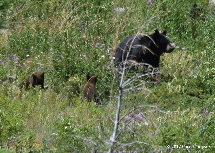
As populated as California is, there are still remote areas that have relatively fewer people, especially in the northern half of the state. Opportunities to get away are protected behind the hassles of winding mountain roads or the labor of long trails. One has to simply be willing to get up earlier or hike farther, and the crowds can be left behind. However even with such effort expended, in California it is rare to be able to completely leave all other people behind. I know of a very small number of coastal areas where this is more or less possible, but I’d rather not name them.

Rocky intertidal at Shelter Cove, looking south.
One less crowded (though by no means secretive) stretch of California coastline is Shelter Cove at the southern end of Humboldt County. It is a small coastal community at the terminus of a torturous narrow road leading from US101 through the coastal redwood “curtain”. To the north and south of Shelter Cove are long stretches of more remote coastline – the King Range area – which I hope to explore more by trail some day.

I was fortunate to catch several of the exceptionally low tides over the Memorial Day weekend. My last stop of three consecutive days was Shelter Cove. It was a lovely morning of tidepooling, marking my return after some 14 years to this site. My first and only other visit was an intertidal adventure memorable in large degree because of a flooded camera. We drove south along US101, leaving the early morning rain in Eureka, and then turned toward the coast. The rain gave way clouds and then eventually to an increasingly sunny morning.

For the coastal explorer, Shelter Cove presents a few kilometers of compelling habitat. I returned to the southern-most stretch of coastline, just north of the cove proper, the approximate 
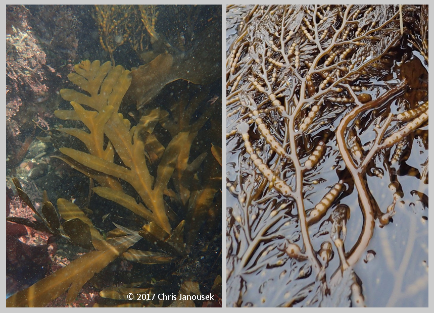
site of the deceased camera. Low tide exposed boulders, cobbles, and a meadow of small brown stipitate kelps. Here the usual low tide kelp dominant Laminaria setchellii, was joined by Pterygophora californica in about equal abundance. Some of the plants were tattered from the abuse of surf or herbivores.

Large brown seaweeds in the low intertidal at Shelter Cove. Laminaria setchellii (left)
and Stephanocystis osmundacea (right).

Pterygophora is a species I typically associate with subtidal kelp forests. Curiously, however it was common in the low intertidal zone at all three sites I visited in northern California for the long weekend. Another very common large brown species at Shelter Cove was Stephanocystis osmundacea (older name = Cystoseira osmundacea). Attached by a tough, almost woody base, this species is large enough to form underwater canopies like several of the kelps, but it is classified in a different order of brown seaweeds. The basal portion of the plant consists of flat pinnately-divided fronds. The top portion is more wiry in morphology and contains the most attractive part of the plant in my opinion: the concatenated pneumatocysts that look like strings of brown pearls, and which function by virtue of holding gases to keep the upper part of the plant afloat.

Stephanocystis osmundacea at Shelter Cove. Basal fronds underwater (left) and
apical portion of the plant with pneumatocysts (right).

The low intertidal into the shallow subtidal was littered with small cobbles which were covered in crustose coralline algae, brightening the substrate with pink and white. Because of their smaller size, the cobbles are likely unstable during periods of high surf, impeding any hope of long-term residence by fleshy seaweeds. The slow-growing, calcium carbonate-encrusted coralline algae however, seemed to find this sufficiently acceptable habitat.

Underwater branching and encrusting coralline algae at Shelter Cove.

In the low intertidal, a little above the water line, I soon discovered my first abalones of the day tucked into a tiny rocky ledge. There were nine individuals! In my experience, it is relatively unusual to find more than a few scattered individual abalones on any stretch of California coastline, but by the end of my wanderings that morning, I ended up counting some 77 or so over about 200 m of coastline.

Red abalones, Haliotis rufescens, in the intertidal at Shelter Cove.


The abalone hunters are well aware of the bounty present at Shelter Cove too. In fact, as I was likely the lone (bipedal) seaweed enthusiast at Shelter Cove that morning, I was quite outnumbered by divers wading in the shallow subtidal with wetsuits and donut-shaped floats looking for specimens of legal size. I have personally never tried the apparent delicacy of the expertly-prepared abalone. Despite my deep enjoyment of many things oceanic, I have generally never been too particularly interested in seafood.

Abalones are even more dedicated seaweed enthusiasts than me, feeding on kelp or other species of macroalgae. The slow-moving mollusks clamp down on a bit of sea salad as it floats by. For some species of abalone, an animal’s choice of seaweeds to dine on can be reflected in shell color. Consumption of red seaweeds, for instance, will lend the shell a reddish color from the pigment rufescine.

Abalones are gastropod mollusks, related to snails, limpets, and slugs. They occur worldwide, but attain their greatest size in the Pacific basin. Along the Pacific coast of North America there are seven species: red, black, green, pink, pinto, white, and flat.

Of these species, red abalones (Haliotis rufescens) seem to be the most common in northern California. It was this species I noted in relatively high abundance at Shelter Cove. The visible part of the tough muscular foot is black in color, protected underneath a generally pinkish to reddish pearly shell. A row of perforations near the margin of the shell are the site where gills expel water. In California this is the only species that can be fished, and even then, it can only be taken north of San Francisco, and by free diving, and during certain periods.

The only other abalone species I definitively recall seeing in the rocky intertidal is the black, H. cracherodii. I found a rare cluster of these organisms while tidepooling at Carmel Pt. south of Monterey in December of last year. Like some of the reds at Shelter Cove, these animals were wedged in a rock crevice. Black abalones occur from Mendocino County south to Baja California and can live at higher elevation in the intertidal than other species.

Black abalones, Haliotis cracherodii, in the intertidal at Carmel Pt.,
Monterey Co., CA, Dec 2016.


Unfortunately abalones tell a tale of coastal resource exploitation. After 20 years of tidepooling throughout California, my experience suggests it is relatively rare to see abalone in any significant number in the intertidal zone. Yet this was not always the case. Older photos from southern California decades ago show intertidal abalones in incredible abundance, covering much of the surface of the rock and crawling on top of each other! Overfishing, El Niño, and disease appear to have contributed to the severe loss of these important coastal ecosystem members. With declining numbers, rehabilitation of populations is now the key focus for these organisms.

Not all west coast species are equally threatened. While a fishery still exists for reds, white abalones (H. sorenseni) are so rare in the wild that they are in danger of going extinct. This species lives in southern California and Baja California in deeper waters. Whites were the first species of marine invertebrate to gain a federal listing of endangered in the United States. NOAA estimates that several thousand individuals still exist in the wild, but these adults may be the last cohort of a species at the edge of extinction. Mating success is dependent in adults being close enough to each other that sperm and eggs have a chance of meeting.

A group of researchers housed at UC Davis’s Bodega Marine Laboratory, are working hard to help recover this species. Black abalones are also federally endangered, having experienced a severe population decline in the last few decades.

References

Calif. Dept Fish Wildlife. No date. White Abalone Recovery Project.

Morris RH, Abbott DP, Haderlie EC. 1980. Intertidal Invertebrates of California. Stanford University Press, Stanford, CA.


NOAA Fisheries. 2016. White Abalone (Haliotis sorenseni).

Ricketts EF, Calvin J, Hedgpeth, Phillips DW. 1985. Between Pacific Tides. 5th ed. Stanford University Press, Stanford, CA.

Dermasterias imbricata at Shelter Cove.
Stephanocystis osmundacea from below.