Sunday 30 July 2017.
 |
| Muriel Lake and Mt. Humphreys in the background. |
Midday, North of Goethe Lake Piute
Pass again in the morning after
camping for the night near Piute
Lake Muriel Lake
Rounding the northern point of
Muriel Lake, we proceeded south, gaining some elevation and eventually obtained
a grand view of Goethe Lake, an unnamed smaller companion lake, Mt. Goethe (13,270
ft), Muriel Peak (12,937 ft), and the Goethe Glacier. The glacier, which was
the original intended destination, was set in a rocky enclave, about halfway in
height between Goethe
Lake Kings Canyon
National Park
 |
| Goethe Lake (left) and Gothe Glacier (right photo at center). |
The whole Goethe landscape was
ruled by granite and snow and beautiful lakes, sparse in life, but abundant in
majesty and contrast. The afternoon of our hike, the air was warm with a cool
breeze belying the assured harshness of the landscape in the dead of winter.
There were still trees at our elevation (~12,000 ft), but they mostly took on a
shrubby growth form. Mosses, grass, and flowers – all of short stature – were
present too, but they must be subject to the realities of a short growing
season.
 |
| A panorama of about 180 degrees, from Mt. Humphreys in the north to Goethe Lake and Goethe Glacier to the south. |
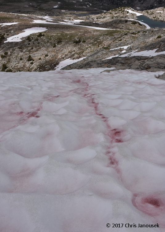 |
| A prominent streak of snow algae near Lake Muriel. |
The snowfields in the wilderness
have presented really attractive patterns and colors to me. Many are tinted red
or pink from algae living within the hardened snow. My friend recently provided
an excellent overview of this “watermelon snow” in her blog here, and you can read more about the algae here. I’ll
only repeat here the main fact underlying this phenomenon – namely, that the
organism responsible for the unusual streaks of color is a green alga, Chlamydomonas, which produces brilliant
carotenoids (orange, yellow, and reddish pigments responsible for the color of
carrots and autumn leaves). In the John Muir Wilderness, the alga was present
on many of the snowfields.
My other snow observation was the
pattern of regular undulations in the surface of many of the snow fields, some
craters exceeding a few feet. I’m unsure how these craters form, but they seem
to arise from the melting process, not from the original deposition of snow.
Most of the snowfields were very firm – approaching ice – and it was relatively
easy to walk across them in hiking boots.
 |
| A fortuitous granite "tent" provided some relief from the sun. |
Early afternoon, NW of Goethe
Lake. Clouds 25%. We climbed a bit higher
to the top of a ridge (~12,080 ft) that separates the Goethe
Basin to the east and the Wahoo Lakes Goethe Lake and its unnamed companion lake, the Wahoo Lakes
We returned to the campsite in the
afternoon. By late afternoon and early evening cloud cover increased to 75% as
the afternoon progressed on the west side of the pass. The valley grew grey and
soon thunder announced her presence. I remarked earlier in the day how I
thought it would be great to have a Sierra thunderstorm, and here she was! A
dozen or so lightning strikes clapped to the east and then rain and hail fell
in a marvelous summer storm. The downpour was intense for a short time, sending
a barrage of precipitation into Piute
Lake
A brief video of the storm:
 |
| Small icebergs at the edge of Muriel Lake. |
 |
| USGS topographic map of part of the John Muir Wilderness (Mt. Darwin quadrangle, 2015), including some of the areas we explored on the second day of the backpacking trip (red dotted line). |
No comments:
Post a Comment