Showing posts with label California. Show all posts

07 June 2026

Disturbance

Mid-May had a fantastic tide series and I was able to explore the rocky intertidal twice. My first early morning stop was on a Sunday at Luffenholtz Beach, near Trinidad California in Humboldt County. I’ve intermittently tidepooled in the Trinidad area over the years, usually going to the rocks just below the old lighthouse. Back in the Bay Area later that day I woke up early again on Monday to visit Mile Rock Beach at Lands End in San Francisco.

Besides the time to photograph and identify seaweeds, both visits were excellent reminders of the role of disturbance in shaping intertidal communities, although each site provided different examples. At Luffenholtz, the extensive intertidal was lush with red algae and kelps, that was until I came upon a small nearly barren area tucked between large rocks which was full of urchins. A bit later, perhaps only 30 meters away, I came upon a second barren, this one much larger than the first. It too was full of urchins. The thick algal canopies that were common elsewhere in the intertidal, only persisted on a few of the highest rocks because the dense urchins, hunkered down in the low intertidal zone, had mowed virtually every rock clean.


Kelps, seagrasses, and other algae covering rocks in the intertidal zone

 Lush intertidal flora at Luffenholtz Beach.


 Lush algae above, urchin barren below at Luffenholtz.

The spread of urchin barrens in the Northeast Pacific, and their decimation of some local kelp forests, is not a new story, but it is still a little shocking when I see examples of this with my own eyes. Multiple visits to the rocky intertidal at Carmel Point near Monterey over about two decades also brought the urchin barren story home to me when I found that a similarly lush area of low intertidal had been dramatically altered by a local urchin explosion.

Luffenholtz was windy in the morning though I did not think too much of it. Wind is common on the PNW coast. However, the wind was still blowing in the Bay Area a few hundred miles to the south by Sunday afternoon and it continued into Monday morning for my next intertidal visit in San Francisco. In the famously foggy city, Monday morning’s wind brought in relatively warm air out of the northeast, keeping fog away and providing temperatures that felt a little atypically warm. This warm, and probably drier, air in fact imposed a terrestrial stressor on organisms that are accustomed to being covered with cool saline water. While many species that live in the higher zones of the intertidal are adapted to fairly long periods of being exposed to air, heat, and wind, low intertidal species are generally less tolerant because they spend most of the time submerged.

Wandering Mile Rock Beach for a couple hours I saw shriveled up low intertidal kelps (Laminaria sinclairii) and stressed out delicate red seaweeds. Some of the red algae may have been literally bleaching before my eyes as they turned from a rich purple red to a sickly orange color. Desiccation stress of this nature may not be terribly frequent; after all it requires that a daytime low tide coincide with strong dry winds.


 Wilting kelps, Laminaria sinclairii, at Mile Rock Beach, San Francisco.


 Bleaching red algae at Mile Rock Beach.

On top of these local or regional stressors, organisms are facing another pervasive disturbance – global climate change. Recently, the Northeast Pacific Ocean has been anomalously warm. Whether directly tied to climate change or not, anthropogenic warming certainly excerbates natural oceanic climate cycles, and adds another layer of environmental stress to the other local factors organisms have to deal with from time to time.

Disturbances are a natural part of ecosystems, shaping short-term ecological dynamics and influencing the evolution of populations and species. They can be short-term or long-term, ocean-basin-wide or happen at very small scales. Yet each can affect the composition of coastal communities in some way. A ripped out patch of large mussels allows smaller species to recruit, or annual sea palm kelps to get a foothold in the middle intertidal zone. An unusually warm wind event during a tide or two will lead to die off of less tolerant algae that may open up space for new propagules to settle.

20 July 2024

Santa Rosa Island


Lying just off the coast of Southern California, the Channel Islands are one of the gems of the state. I’ve recently had opportunities to spend time on two of the eight islands – four weeks on Catalina Island last fall to teach a field course (more on that later), and five days this spring on Santa Rosa Island. Santa Rosa is one of five islands that make up Channel Islands National Park. Those five days of camping, hiking, tidepooling, snorkeling, and photographing deserve more than a single blog post, but as I’m finding it difficult to make time to write here, I’ll at least document a few highlights in this post.

Torrey Pine forest. The Torrey Pine (Pinus torreyana) has been described as the rarest member of its genus in the world, growing naturally only in two small geographic regions in California. Populations are found along a thin strip of coastline north of La Jolla and on Santa Rosa Island. Back in my graduate school days, I visited Torrey Pines State Park a few times. While on the island, I hiked to and through the main Santa Rosa population a few times, starting on my first afternoon in the park. The main concentration of trees lies only about a mile or so east of the Water Canyon Campground on the northeast part of the island. The trees grow on a north-facing slope from about the ridge of a hill down to the bluff above the ocean and are present in all sizes from tiny saplings to shrubs to mature trees. Needles on this pine species are in bundles of five and cones are rather rounded. One of the other notable observation about the Santa Rosa grove was the abundance of flowers of various species, a visual treat which repeated itself on other parts of the island during my visit. This past winter the Pacific Ocean was in El Niño conditions, and that oceanographic state brings a decent chance of a wet winter in southern California.

Immature cone of a Torrey Pine, Santa Rosa Island.

East Point. Water Canyon Campground was my base camp for the trip from which I fanned out for different day hikes on the island. On my second full day, I made the hike out to East Point, leaving early in the morning. The trail took me through the Torrey pine forest, then southeast down a long valley full of grassland and some shrubs. I took my shoes off to ford a small creek with knee-high water, full of cattails, and then rounded a small estuary. After about three hours, I finally made it to East Point, a rocky point from which the south and east sides of Santa Rosa Island and the west side of Santa Cruz Island could be seen. Elephant seals were common on the beaches north of the point and a few were in the offshore kelp forests in the area, black buoyant snouts sticking out of the water. Although that morning was part of a waning morning of good low tides, I made it in time for the tide and it was good enough to expose an assortment of seaweeds and invertebrates. I explored, photographed, and made notes about intertidal organisms for a while and then made the long hike back to the campground in the afternoon.

Elephant seals on the east side of the island.

Lobo Canyon. My second long day trip was to Lobo Canyon, on the north side of the island, a round trip that occupied a full day of exploration. Several people had mentioned this special place, and they were not incorrect. The hike out is rather unimpressive as it takes one through rolling hills covered in dry non-native grasses, but after a few miles beyond the historic ranch, one descends into this botanically and geologically remarkable canyon. Lichen-covered trees cover the sides of the canyon, and in the riparian corridor at the canyon’s bottom (which the trail follows), there are all kinds of interesting plants including willows, horsetails, ferns, and all sorts of flowering species. A ways down the canyon, the remarkable geology becomes prominent. Here are beautifully sculpted patterns in the vertical sandstone bluffs, a delight to photograph. High on one small ledge, a rough next was home to three baby peregrine falcons, ready for their next meal. Finding the nest was a bit of teamwork – a visiting naturalist noted that the canyon was home to these nesting falcons and then I eventually visually spotted the nest’s location. I hiked out to the mouth of the canyon and then a short distance along the island’s north coast to the next small canyon where there was a little waterfall.

Peregrine falcon nest on a sandstone wall in Lobo Canyon.

Bechers Bay snorkel and tidepooling. On the drive down to Southern California for this trip I had stopped in Monterey where I purchased a new snorkel mask and hood, and since I had hauled all of my snorkel gear out to the island’s campground, I felt compelled to attempt a snorkel if conditions were favorable and not chicken out due to cold water. By my last full day on the island, the very windy conditions of my first 48 hours on the island had abated considerably and so this was my chance. I opted to explore a very small kelp forest to the south of the landing pier in Bechers Bay. Conditions were calm, though overcast, and the snorkel itself was fine but the water was unfortunately quite murky. To see anything beyond the sparse seaweed canopies reaching the surface, short free dives were necessary. On the mostly sandy bottom, there were urchin barrens in places and other small rocky outcrops with more diverse assemblages of algae and invertebrates in other places. Along with urchins and a few other invertebrates, I saw two large spider crabs (Loxorhynchos grandis), unfazed by my presence. While conditions were much poorer than my snorkeling last fall on Catalina, I’m glad I made the attempt.

Paintbrushes and lupines in Cherry Canyon.

Torrey pines and morning moon, Santa Rosa Island.


08 May 2022

Death Valley: Wildrose Peak

The deserts of southeastern California and Nevada are expansive, and their large size is driven home by the maze of valleys, canyons, and mountain ranges that add complexity to the landscape. The Panamint Range runs from north to south at the western end of Death Valley. It is a relatively high range, with several peaks over 9000 ft, but it becomes even more prominent in consideration of its position between two low desert valleys to the east (Death Valley) and west (Panamint Valley). In fact, the highest peak of the range is Telescope Peak at over 11,000 ft, which is just miles from the lowest point in North America: Badwater Basin in Death Valley at nearly 300 ft below sea-level.

I set out to Death Valley National Park in late February for a photography project, with just a general concept in mind, and few set destinations. After a first night in the backcountry in northern Panamint Valley and an easy hike to Darwin Falls the following morning, I decided to travel down Emigrant Valley Road, find a campsite at Wildrose campground if available, and continue the drive up Wildrose Canyon. By mid-afternoon I was far up the canyon past the start of the juniper and pinyon pine tree line, and at the start of the trail to Wildrose Peak. I grabbed several cameras and started the hike.

Unfortunately I started too late in the day to make it very far along the trail, but I returned the next morning arriving at the trail head by 7:30. It was cold: 22°F according to my car! Starting up the trail again I passed junipers, pines, and patches of snow. The sun was rising in the east and broke through for a moment, providing some welcome warmth. I climbed towards the east and at an elevation of just under 8000 feet I arrived at a ridge that provided an expansive view of Death Valley to the east. Sunshine was now a regular companion on the trail, and though the air was still cold, it make the hike more enjoyable.

The trail continued to the north and then back to the west, ascending a bit more than another 1000 ft before it would end at Wildrose Peak. Snow patches were common, but in most places they were a thin crust on the cold ground, unlikely to provide much water at all once they melted. The snow may have fallen earlier in the week when California finally – after a remarkably dry January and February – had a winter storm pass through the state. On my drive from Davis through the Central Valley I caught a bit of the storm in Tehachapi Pass where rain, hail, and snow were falling.

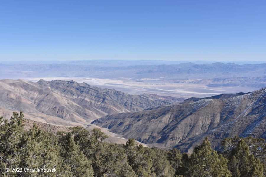
The top of Wildrose Peak afforded incredible views of the southwest desert landscape. To the east Death Valley and the Amargosa Range were visible, and Nevada could also be seen including a distant peak with some snow to the east. The lower elevation Panamints were to the north. To the south, Telescope Peak, the highest point of the Panamint range, dominated. Though that mountain was also dotted with dark green evergreens (presumably also junipers and pines), it seemed to have a thicker blanket of snow. To the west was the Panamint Valley and then other mountain ranges, including I’m almost sure, a distant ridge of jagged snow-covered mountains that must have been the eastern edge of the Sierra Nevada.


Death Valley to the east

The mountain top at Wildrose Peak had a rock cairn, USGS benchmark, and a metal box with a logbook. A raven was perched at the top of the cairn for sometime before flying off. The mountain top was rather rounded, like the other nearby peaks in the Panamint range. The smoother summit topography perhaps indicates a more ancient origin, with millions of years of erosive forces mellowing the mountains in their old age. While evergreens reached to about the summit of Wildrose, the vegetation was rather low lying and sparse, the species most catching my eye was a prickly pear cactus with long spines, the clusters of stems lying close to the ground and mixed in with snow patches and rocks.


Crest of the Sierra Nevada range to the west

Wheeler Peak to the south

Cairn at the summit of Wildrose Peak


05 February 2022

Scoliopus bigelovii

I was out on the northern California coast last weekend for the excellent low tide series. Saturday night I camped at Stillwater Cove Regional Park with the plan to head up to Mendocino County the next day. The clear moonless night gave way to a cool morning and I hiked a bit up the redwood-filled canyon in the park.

Down in the forest understory I noticed pairs of variegated leaves, standing stout like small green vases and eventually found some in flower. The distinctive leaves I’d probably seen before, but I’m not so sure about the even more distinctive flower. It seemed like a new discovery. Back home, a relatively quick look through the lilies in the Jepson manual landed me on Scoliopus bigelovii, a monotypic genus of plants found on the northern California coast (Baldwin et al. 2012). Lilies, including Calochortus, have long been one of my favorite families of plants and now I have found another!


The showy flower has parts of three (indicating a monocot) and appears early in the calendar year according to Jepson and the Marin chapter of the California Native Plant Society. That latter source indicates that the plant’s leaves are still rather small when the flower appears on a long stalk that eventually nods towards the ground when the flower has been pollinated. If you're out on the redwood coast during the early months of the year, see if you can find this beauty!


28 August 2021

Stalked jellies

When I was an undergraduate student, I had considerable interest in marine invertebrates, particularly the simpler groups such as the jellies and comb jellies. While I soon turned my attention more to marine algae and later to higher plants, I still find that these simple groups of marine invertebrates are fascinating to behold. They are simple, elegant, and beautiful.


Tidepooling at Trinidad in Humboldt County in late June this summer I found interesting examples of a less common group of these soft bodied, simple invertebrates. I am pretty sure I have not seen these organisms in the field before, but have been aware of them for a while. Classified in the Phylum Cnidaria, this group is known as the Stauromedusae, Staurozoans, or stalked jellies. Cnidaria are comprised of many soft-bodied, often translucent invertebrates that many are familiar with including anemones, corals, and jellyfish. The stalked jellies are sometimes given their own taxonomic class, or order within the class that includes pelagic jellyfish.

The dozen or so animals I found at Trinidad were in shallow pools in the low intertidal zone, each animal only about 2-3 cm in size. They were attached to blades of red algae by an elongated stalk. The other end of the animal broadly flared out like a trumpet and included eight tentacles. Because these animals are very small, perhaps they have been at other sites up and down the Pacific coast I have explored and I have just overlooked them in the past.

I don’t know much about the biology of these organisms, but Dr. Claudia Mills at the University of Washington has a nice summary here. More images of Staurozoans can be seen here.


19 September 2020

Western climate fires

The extent of the fires sweeping through the west this summer is sobering. As I perused an interactive map published by the New York Times earlier this week, zooming in and out on fire after fire, it dawned on me that several locations I have visited for recreation or traveled through in just this calendar year – in multiple states even – have now burned in the summer fires.

The extent of wildfires in the western US on 15 Sept 2020. Map from InciWeb.

During April, in one of my first hiking excursions since the coronavirus lockdowns began, with my daughter I hiked among and photographed flowers and oaks along the western shore of Lake Berryessa in Northern California. In the LNU fire to tear through that area this summer, most of the western shore of the lake burned. In fact most of the coast range hills down to Interstate 80 between Vacaville and Fairfield have burned.

Oak woodland and blooming lupines during April 2020 on the western shore of Lake Berryessa.

To the east of Lake Berryessa is a hiking location I visit often, the Stebbins Cold Canyon Reserve. It is a teaching and research reserve operated by the University of California, Davis but is open to the public for hiking. Like other places in California was closed for a time due to the coronavirus pandemic. Within a short time of opening back up this summer, I briefly hiked there on a warm day. Signs of a fire several years ago were still evident on the landscape, particularly on the western side of the canyon, but smaller shrubs and smaller plants have recovered. According to the maps though, it appears the whole canyon has burned again.

Also succumbing to the same complex of fires was an area to the northeast of Lake Berryessa, a hiking place I only discovered this spring in my search for more local hiking areas during the pandemic. Valley Vista Regional Park is a small county park located near the scenic Cache Creek and California highway 16 and it features grasslands and lovely oak woodland. This whole area too, it according to the maps has burned.

Oak woodland at Valley Vista county park earlier this year.

The extent of the LNU complex of fires in northern California during summer 2020. Asterisks mark approximate locations I had been hiking at earlier times in 2020. Map from InciWeb.

Finally, on my road trip through Wyoming and Colorado this July, I spent a night camping, and few enjoyable hours hiking in the Roosevelt National Forest north of Rocky Mountain National Park. I hiked into the Comanche Peak Wilderness near the headwaters of the Cache de Poudre River, a lovely valley of aspens and conifers. Virtually the whole wilderness was covered by a large fire.

The Roosevelt National Forest in July 2020. At left: Cache de Poudre River; at right: a grove of aspens. 

The Cameron Peak fire extent in the Roosevelt National Forest. Map from InciWeb.

----

We increasingly see signs that climate change is here now. It is not just a phenomenon modeled to occur in the future. While scientists are often reluctant to attribute any specific natural disaster to changing climate, it is becoming more clear with each passing year that we may be entering uncharted territory. In the bigger picture, warming seas are making Atlantic hurricanes more intense. Sea-level rise due to warming and glacier melt is increasing the frequency of nuisance flooding in American cities. And for the last several years in the far western US, the fires have become worse and worse.

The summer fires of 2020 – some call these climate fires – have been everywhere in the western US. In addition to the very places I hiked or photographed or camped in this year, other western landscapes have burned. The beautiful, remote coast of Big Sur: a major fire. The Mendocino National Forest: a massive complex of fires that is still burning. The gorgeous Oregon Cascades: fires so bad they sent air quality levels in Portland and the Willamette Valley to extremely hazardous levels making the region have the worst air quality on Earth for a while. In the Sierra Nevada: several large fires. And northeast of Los Angeles, east of San Diego, and in eastern Washington: more fires.

With each passing year the most pressing question is less about the science and impacts of climate change (although science will always be crucial to monitoring, predicting, and responding to climate change), but rather whether society sees the accelerating pace of change and wants to seriously do something about it. Without reducing carbon inputs into our atmosphere, our future may becoming increasingly uncomfortable, costly, and even deadly.

Burned oak woodland just south of Interstate 80 near Vacaville and Fairfield in northern California. Photo: 16 Sept 2020. 


16 June 2018

Scott Creek


There are fantastic low morning tides in the northeastern Pacific this week and I came out to the central California coast very early this morning to survey marine algae at a few sites. Up today was Scott Creek, a location in northern Santa Cruz County that I have visited since my undergraduate days. Scott Creek itself is a small creek that flows under Highway 1 and empties into a sandy beach. To the north of the sandy beach are extensive intertidal sandstone benches with an abundance of sessile invertebrates and algae.

Scott Creek is often very windy, but was less so early this morning. There was a moderate swell and overcast skies that turned into drizzle as the morning progressed. The tidepools revealed nothing of great surprise to me today, but the tide was exceptional and exposed extensive low intertidal beds of the surfgrass Phyllospadix torreyi. Kelps and red seaweeds were in abundance. Bull kelps (Nereocystis luetkeana), one of my favorite seaweeds, were rather common, occurring as scattered individuals or in clusters of more plants. The sporophytes of this species ranged considerably in size, from a very small plant with tiny pneumatocyst and single as-yet-unbifurcated blade, to plants of several meters length with thick stipes and large pneumatocysts.

A sampling of some photos from today:

Bull kelps: larger sporophytes.
Smaller bull kelp sporophytes.
Laminaria sinclairii, another common kelp at Scott Creek. This species grows as
aggregates of stipes and thin blades, typically in intertidal areas scoured by sand.
Callophyllis, an attractive genus of smaller red seaweeds that grow in the low intertidal.
Osmundea (Rhodophyta).

Bryopsis. I found a few of individuals of this small green
seaweed in a tide pool in the mid intertidal. 

21 April 2018

California's marine biogeographic break

Felimeda macfarlandi, a chromodorid nudibranch at Cambria.

This month I’m repeating my spring road trip through the southwest, but oppostite of my general course last year, I’m first heading down the California coast. My focus is on marine life for a few days and then I head to the deserts and mountain ranges inland. Cambria was my first stop on Thursday morning on the central coast just south of Big Sur.

At Cambria, fleshy red seaweeds, surfgrass, kelps, and invertebrates filled out the rocky sandstone boulders and bedrock. I again saw a healthy population of the rockweed Pelvetiopsis hybrida, a seaweed I first encountered and wrote about last year. There were adorable small sporophytes of bull kelp in a handful of small patches in the low intertidal. One new find was a beautiful purple chromodorid nudibranch, gliding among leafy red algae.

Young sporophytes of Nereocystis luetkeana (bull kelp)
in the low intertidal at Cambria. Egregia menziesii is in
the background.


Friday morning I was at the Palos Verdes Peninsula in Los Angeles. Remarkably I have never been tidepooling in LA County despite growing up in the region and attending graduate school in San Diego. Pt. Fermin was my planned destination, but when I arrived there in the morning, all access was officially blocked off. Skirting around a barrier would have been no problem, but it didn’t seem advisable. Instead I drove a little farther north to White Pt.

Relatively strong surf pounded some high relief rocks in the intertidal just off the southern parking lot. I explored a section of coastline south of there, almost to White Pt. itself. The site was comprised of sandstone benches, boulders, and cobbles, a drab yellow color.

The changed character of the biota between central California and Los Angeles was immediately evident. I was struck with the incredible abundance of barnacles in the upper intertidal at White Pt. – a desert as far as macroalgae were concerned. Red fleshy seaweeds were essentially non-existent, and the large seaweeds (a few species of kelps and large brown algae) were generally limited to the low intertidal zone.

I had crossed a well-known biogeographic barrier by entering southern California, and the marine flora in particular indicated this dramatic change in biotic composition. Point Conception north of Santa Barbara is often regarded as the break; this is where the mainly north-south coastline of northern and central California bends toward the east to form the southern California Bight. North of Point Conception, water temperatures are cooler and there are pockets of coastal upwelling that bring nutrient-rich cool water to shallow depths for photosynthetic organisms to enjoy. The north-to-south California Current dominates the near-shore. South of the point, waters are warmer and the south-to-north Davidson Current is present. Hot and dry Santa Ana winds that blow from the northeast can bake the southern California coast.

A wave crashing into sandstone benches just north of White Pt., Los Angeles Co.


A cowrie at White Pt.
Desiccation stress, always a concern for aquatic organisms which are periodically exposed to air, may be more intense in southern California than in more northerly parts of the state. More intense sun, less rainfall, and warmer temperatures in southern California probably exacerbate desiccation stress in southern California.

I found the abundance of small barnacles in the high intertidal curious. These organisms must be hardy against desiccation – they are exposed to air most of the time after all – but I wonder how being clamped tightly shut most of the time affects their ability to capture food. They must open up and sweep the water in order to catch food particles.

Except for the low intertidal which is submerged often, tidepools were the other microhabitat at White Pt. where larger seaweeds were likely to be seen. Relative to the central coast, however, these were not particularly large, consisting of branching coralline algae, Gelidiales, and others. Small fish darted to hiding spots when they sensed me nearby.

Common low intertidal kelps north and south of Pt. Conception. Left: Laminaria setchellii at Cambria. Right: Eisenia arborea at White Pt.

One of the interesting kelps of southern California that is not seen farther north is Eisenia arborea. Its species name suggests “tree”, and that is not an inaccurate moniker. Eisenia is a small kelp species, born on a stiff stipe from which two sets of blades droop down in a sort of disheveled brown mess. At White Pt. it was almost exclusively in the low intertidal, with some stragglers a little higher up where pools were present. Eisenia also occurs in Japan. In central and northern California Laminaria setchellii takes its place in both overall form (though it is not such a mess) and in ecological niche. I’m curious to know if these species overlap in distribution at all, or where one begins exactly and the other ends. Some exploration of Santa Barbara and the northern Channel Islands holds the answer to that question I think.

Juvenile spiny lobster (Panulirus interruptus) in a tide
pool at La Jolla. It's carapace was about 3-4 cm long.
Today I was in La Jolla. The flora was different yet again, but more similar in overall growth form to White Pt. than Cambria. Eisenia was present, but so too was a small kelp, Laminaria farlowii, that I didn’t see in Los Angeles. These plants are simple ruffled blades, aggregating or growing as singlets in the low intertidal. La Jolla also had a remarkable contingent of brown seaweeds of the order Dictyotales. This group tends to favor tropical and subtropical regions globally.

At La Jolla I explored the area around Nicholson Pt., a series of sandstone benches between the posh homes and the Pacific. Ravines, and even an arch, were cut into the sandstone. In the mid and high intertidal were also pools of various depth and diameter – all providing a variety of microhabitats for marine organisms. The beautiful marine plants notwithstanding, today’s best find was probably a tiny lobster in the warm water of a pool in the mid-intertidal! I’m tempted to tidepool once more tomorrow morning, though I originally planned to leave early for Arizona. We shall see!


Zonaria farlowii (Dictyotales) was very common in low elevation
sandy tide pools at Nicholson Pt., La Jolla. This species grows in
elegant rosettes.


07 April 2018

Pigeon Point intertidal


Pigeon Point in San Mateo County, CA is one of my favorite tidepooling
locations and I have visited this area for many years. In late March I returned
to the south side of the point. Here waves crash into rocks with a population of
the sea palm, Postelesia palmaeformis. The Pigeon Pt. lighthouse is in the
background.
Many of the palms exhibited desiccation stress, perhaps due to a combination
of mid-day low tides, warm sun, and wind. 
Another of my favorite kelp species on the California coast is this species,
Dictyoneurum californicum. It occurs as clusters of blades on rocks in
the low intertidal. I love the color and texture of the blades. 
At least two species of seagrasses in the genus Phyllospadix appear
to be present at Pigeon Pt. Here is P. scouleri underwater. It
occupied the low intertidal, often in channels between higher rocks.
Red seaweeds (Rhodophyta) are the stars of the show at Pigeon Pt. since they are in such high abundance relative to other seaweeds. Here is a sampling of species. From left to right is Osmundea spectabilis, Sarcodiotheca gaudichaudii (with some small epiphytic Microcladia coulteri), and a coralline alga - the most unusual "rhodolith" I've ever seen!
"Leafy" red seaweeds were relatively common in the low intertidal too. I
think this is one of the Botryoglossum species (Delesseriaceae).
Out on the rocks near the sea palms there were a few deeper tide pools
that had anemones, and high concentrations of purple urchins. 
I found a sculpin in one of these pools as well.
Finding this tube worm, Serpula columbiana, and photographing it underwater
was a treat. The colorful plume is used to catch food and accomplish gas change.
The operculum can be seen behind the the plume at top right. It is used to seal up
the tube when the animal retracts. Hat tip to my friend Allison Gong for the
species name. 

25 December 2017

Incredible plants: giant sequoia

General Grant tree in the Grant Grove, Kings
Canyon National Park, 2014.
California is a land of superlatives, and especially so botanically. Trees are at the top of the list for California’s record breaking plants: the state is home to the world’s oldest trees (the bristlecone pines, Pinus longaeva), the world’s tallest trees (coast redwood, Sequoia sempervirens), and the world’s largest trees by volume (the giant sequoia, Sequoiadendron giganteum). Each of these record-setting trees occurs in different geographic areas and environments among California’s diverse set of geologies and climates. They are all conifers, a widespread group of gymnosperms (gymnosperms are seed-bearing, but flowerless, vascular plants).

The giant sequoia has a narrow geographic range, found solely on the western slopes of the Sierra Nevada range in central California. It occurs across a fairly broad range of elevations (825-2700 m), though most populations of the species lie between about 1800 and 2100 m above sea-level (Yu et al. 2017). Upper and lower elevations of the species may be limited by low temperatures and low precipitation respectively. The coast redwood is distributed in the coast ranges from central California to southwest Oregon. It typically grows at much lower elevations than the giant sequoia and generally in close proximity to the coast with its cool and foggy maritime air.

The coast redwood is believed to be the closet living relative of the giant sequoia. Both species are classified in the conifer family Cupressaceae which includes cedars, junipers, and cypresses. Metasequoia glyptostroboides (the dawn redwood), which occurs in China and was only discovered within the last century, is a cousin to the two California redwood species. Fossil evidence suggests that redwood-like trees were formerly much more widespread in distribution across the Northern hemisphere. Sequoiadendron for example, may have been distributed in the past in North America, Europe, and New Zealand. Thus, these three redwood species might be considered relict species with greatly constricted modern distributions relative to the past. Perhaps glacial cycles (increased northern latitude ice cover implicated in the case of Metasequoia) and other factors over time have led to the range constriction of this group of conifers.

Hypothesized evolutionary relationships among giant sequoia (Sequoiadendron giganteum), coast redwoods (Sequoia sempervirens), the dawn redwood (Metasequoia glyptostroboides) and other Cupressaceae. Tree after Kusumi et al. 2000. 

The giant sequoia is a behemoth, estimated to be greater in volume than any other tree species in the world. The largest individuals have an imposing presence in the mixed conifer forests in which they occur. The base of the trunk in the largest individuals can often reach up to 11 m in diameter and 90 m in height (a little shorter than the coast redwood). The giant sequoia has reddish fibrous bark like the coast redwood, with deep furrows evident in older, larger trees. Old growth individuals may live several millennia.

Needles and cones in the giant sequoia and coast redwood are different enough to enable easy identification (in addition to differences in native range between the species). The giant sequoia has short pointed leaves that emerge from stems in a radial fashion, whereas most leaves on the coast redwood are pinnate sprays of leaves flattened in one plane. (An interesting exception is the leaves at the very top of a coast redwood which look quite similar to giant sequoia leaves in overall form.) Giant sequoia trees have both male and female cones on the same individual. Female (seed-bearing) cones of Sequoiadendron and Sequoia are both egg shaped and similar in morphology, but cones of the giant sequoia are about twice as large, almost the size of a chicken egg. Female cones of the giant sequoia are produced in clusters high in the foliage and bear small papery seeds a few centimeters in size.

Foliage of giant sequoia (left) and coast redwood (right). Photos from Bearskin Grove, Sequoia National Forest (2014) and Ventana Wilderness, Los Padres National Forest, Big Sur (2015).


Female cones and seedling of giant sequoia, Tuolumne Grove, Yosemite National Park, 2017.


Several giant sequoias with other conifers in the
Tuolumne Grove, 2017.
Fire is a necessary ecological disturbance for the persistence of the species. Unlike coast redwoods which can grow semi-clonally (e.g., from burs), sequoias generally only produce new individuals from seed, though new shoots can develop from injured stumps in younger trees. Mature trees are resistant to fires of low to moderate intensity which remove understory plants and favor sequoia seed germination by exposing bare soils for germination and increasing light levels reaching the forest floor. When occurring in mixed conifer species forests, sequoias are often found with sugar pines (Pinus lambertiana) and white firs (Abies concolor). Lack of fire will promote white fir relative to giant sequoias.

Controlled fire is used today by some agencies to manage sequoia groves. Reducing woody biomass in the forest understory is a means of protecting groves from more intense large scale-fires made more likely by decades of fire suppression practices in the western US. 

With its immense size, the giant sequoia was a prized timber species in the 19th century. Many of the 67 groves of living giant sequoia are currently protected on state or federal land. This includes three groves in Yosemite National Park and many groves in Sequoia and Kings Canyon National Parks. Additional groves within Sequoia National Forest were protected from commercial logging (which occurred up until the 1980s) with the creation of Sequoia National Monument in 2000. The groves vary greatly in size, old-growth forest extent, and logging history. The smallest of all groves is also the most northerly grove in Placer County west of Lake Tahoe. It has only 6 trees.

Panorama of the Muir Grove in Sequoia National Park, 2014. The sequoias are clustered at top center and can be distinguished from other conifer species by their slightly yellow-brown color and bushy crowns.

Sequoias are vulnerable to root disturbance and intense fires. Climate change might also present challenges to the species persistence, possibly through increasing drought impacts in the future in the Sierra. For instance, recent work by Yu et al. (2017) suggests that drought impacts may be more severe in sequoia groves than in nearby forests dominated by other tree species. However, Willard (2000) suggests that groves have been doing well recently, with many recovering from historic logging and some expanding in size.

References

Baldwin BG, Goldman DH, Keil DJ, Patterson R, Rosatti TJ, Wilken DH. 2012. The Jepson Manual. Vascular Plants of California. 2nd ed. University of California Press, Berkeley, CA.

Eckenwalder JE. 2009. Conifers of the World. The Complete Reference. Timber Press, Portland OR.

Kusumi J, Tsumura Y, Yoshimaru H, Tachida H. 2000. Phylogenetic relationships in Taxodiaceae and Cupressaceae sensu stricto based on matK gene, chlL gene, trnL-trnF IGS region, and trnL intron sequences. American Journal of Botany 87:1480-1488.

Su Y et al. 2017. Emerging stress and relative resiliency of Giant Sequoia groves experiencing multi-year dry periods in a warming climate. Journal of Geophysical Research: Biogeosciences 122:3063-3075. Preprint link.

Weatherspoon CP. 1986. Silvics of giant sequoia. In Weatherspoon et al. Proceedings of the workshop on management of giant sequoia; May 24-25, 1985; Reedley, California. USFS General Technical Report PSW-95.

Willard D. 2000. A Guide to the Sequoia Groves of California.Yosemite Association, Yosemite National Park, CA.

Sequoias in the Muir Grove, 2014.

Cluster of female cones (left) and close-up of trunk (right), Tuolumne Grove, 2017.