Showing posts with label volcano. Show all posts

26 July 2017

Tree imprints at Craters of the Moon

Our last point of outdoor exploration as we looped through the Pacific Northwest this summer was Craters of the Moon National Monument in south central Idaho. The monument, a large expanse of black rugged volcanics, interrupts the otherwise dry brown Snake River plain that stretches across the southern part of the state.

A relatively short road leads through the most easily-accessible part of the monument. It is perfect for a visit of only a few hours, which it turns out was all the time we had that day, and which it also turns out was plenty of summer sun exposure in a landscape mostly devoid of shade.

We first stopped at Inferno Cone, a smooth black cinder cone. My two boys dashed up the slope and I followed a few minutes later. The mountain is a smooth cone of volcanic ejecta, mostly black with an outcrop of some reddish rock near the top. Some of the lightweight black cinders were especially iridescent. The top of the cone provided panoramic views of the volcanic monument and mountains to the west. A strong wind blew gusts of warm dry air from the south. Inferno Cone wasn’t unlike the larger Cinder Cone at Lassen National Park that I described in an earlier post.

Three views of Craters of the Moon National Monument from Inferno Cone.

Pines and shrubs near the trail to the tree imprints.
The next stop was a short trail at the southern end of the road. The trail led south through dry shrubland with occasional occurrences of five-needled pines, most of which were probably not more than 10 meters tall. At some point along the trail we entered the Monument’s wilderness, which apparently is the first wilderness area that was ever designated in any National Park Service unit in the country.

The end of the maintained trail featured some usual imprints of ancient trees – technically fossils I would assume – that were immortalized in past flows of hot lava. The tree “molds” as they were called were of two types. The first type was trunks that were encased in lava and which later decomposed, leaving a cylindrical vertical hole in the newly hardened rock. The second type was horizontal impressions of fallen logs. In the more impressive examples of this type of mold, the texture of the tree’s bark was exceptionally preserved. The patterns in the rock looked much like the bark of pines and I wonder if the species immortalized in the lava could possibly be identified by carefully comparing the prints with modern species. 


Two types of tree "molds" preserved at the Monument.
This volcanic rock looked like a skull or a turtle shell to me.

02 May 2017

Arizona's canyons and cinder cones

After backpacking for a night in the Petrified Forest, the rest of my time in northern Arizona was a bit of a whirlwind of short visits to a couple of other NPS and BLM sites including Sunset Crater Volcano National Monument, the south rim of the Grand Canyon, Walnut Canyon National Monument, and BLM land near Kingman for wildflowers.

Sunset Crater Volcano is a small monument located just a short distance north of Flagstaff. It features a black and brick red cinder cone that erupted less than a thousand years ago, and an older and shorter volcano. The smooth slopes of the mountain are lightly forested.

View of Sunset Crater Volcano from the west.

The Grand Canyon is of course world famous, though this was my first time ever visiting the park. I didn’t leave much time in my schedule at all that day, so my visit consisted of a few stops at lookout points along the south rim. The canyon is immense, although I’m not sure I was as impressed with the view as I was with the view from Canyonlands NP the week prior in Utah.

Fisheye view of the Grand Canyon from Moran Point on the south rim.
Walnut Canyon.

Walnut Canyon National Monument is another small NPS unit in the Flagstaff area. A canyon several hundred feet deep winds through the area with grey and beige colored striated rock forming the walls of the canyon. Like Mesa Verde and Bandelier, the canyon contains Ancestral Pueblo cliff dwellings which form one of the main attractions of the site. The canyon floor, slopes, and tops of the mesas are forested with juniper, pinyon pine, and Douglas fir. Banana yucca and Opuntia cacti were common.

En route to southern California, my last Arizona adventures were in the Kingman area in the northwest part of the state. Some distance east of Kingman along Interstate 40 I began to notice abundant wildflowers as I was driving, including the orange flowers of desert mallow. So, in Kingman I stopped at the BLM office to scope out some potential places to wander around and I ended up exploring a little along the western slope of the Hualapai Range. I found a diversity of plants in bloom and collected a few small specimens to press in a book. Farther along I40, south of Kingman, I also discovered blooming ocotillo, one of my favorite desert plants. Growing in tall scraggly tufts from the ground, this species cannot be missed even from a fast-moving car, and even less so when it shows off its fiery red flowers.

Left: Forested volcanic field on a slope just west of Sunset Crater Volcano. Right: Bright yellow lichens colonizing volcanic rock.
Whiptail lizard at Walnut Creek National Monument.
Cliff Dwellings at Walnut Canyon. Unfortunately early explorers and collectors damaged many of the dwellings in this area, including using dynamite to knock down the ancient walls.
Colorado River at Grand Canyon National Park from
Desert View on the south rim.

18 September 2016

Butte Lake, Lassen Volcanic National Park

View of Mt. Lassen from inside the crater of  Cinder Cone,
Aug 2016.
Except perhaps for Redwood National Park, I've been to Lassen more times than any park in the National Park System. Thursday the 25th of August was the official one hundredth birthday of the NPS. Lassen too is celebrating its 100th birthday this year. But can a few trips alone do justice to any of the west’s marvelous parks? The weekend following the centennial birthday party, I visited a new corner of Lassen: the northeasterly Butte Lake.

Butte Lake lies east of Mt. Lassen, on the dryer side of the Cascades. The roads were dusty and pines dominated the landscape, a clue to the presence of a drier landscape on the eastern side of the park. The lake is at just over 6000 ft elevation and is presently sort of sickle shaped. It may have been larger at some point in the past. The southwest shore is comprised of heaps of jagged black lava rock that come right to the shore, part of the Fantastic Lava Beds. When this lava flow was deposited, it perhaps buried part of the more extensive lake. Only a few willows or other plants have been able to become established in the poorly developed soils among the dark unforgiving volcanic rubble.
Persicaria (left) and Sagittaria (right) in Butte Lake.

I kayaked around some of the northern end of the lake. Visibility wasn't great, and the water had a greenish hue probably due to plankton or other suspended particulates in the water. But it was refreshingly cool, which was very welcome given the dry and dusty surrounding landscape. Some of the shores supported tiny wetlands comprised of typical marsh plants such as Juncus (a rush) and Carex (a sedge). In the shallows at the edge of the lake there were also submerged aquatic plants, such as the floating Persicaria. A few of them displayed short spikes of pink flowers above the water surface. Intermixed, but in less abundance, were the floating arrowhead-shaped leaves of Sagittaria. At the tiny wetland near the boat launch, dragonflies and wasps were abundant. Water striders balanced on the surface tension of the water, distorting the surface and thereby leaving unusual shadows on the muddy bottom. 

To the south of Butte Lake, lies the conical Cinder Cone, one of the types of volcanoes contained in the park. It is a dark grey heap of barren gravel and rubble, set cleanly on the Lassen landscape like a pile of sugar dispensed from a heavenly hand. A hiking trail leads from Butte Lake to the east side of the mountain, rising quite steeply from the base up to the rim of the crater. Incredibly, a few trees have taken root on the outside of the cinder cone, where no real soil seems imaginable. A larger number of conifers can be found just inside the lip of the rim where water possibly collects and the wind may be less harsh. The base of the crater is perhaps a hundred meters below the rim, the interior shaped like a funnel inside the mountain.

The Milky Way, with a silhouette of Cinder Cone at bottom
center.
Saturday night after the darkening sky began to reveal an abundance of stars I ventured out to the rubble volcanic barrens next to the lake to photograph the sky. During about an hour and a half of photography, I noted some half dozen to a dozen shooting stars. The Milky Way spread in a luminous arc above, a wide ribbon stretching from south to north across the sky busy with so many stars.

References

US Geological Survey. 1995. Prospect Peak, CA. 1:24000 topographic map.


Lake Helen and Lassen Peak.
Shadow from a water strider on the bottom of Butte Lake.

28 November 2015

Restless Kilauea

Halemaumau Crater inside Kilauea's caldera.
Kilauea lies on the southeastern slopes of Mauna Loa. One of five volcanoes on the Big Island, it is the most active. The caldera itself is one of the centerpieces of Hawai’i Volcanoes National Park. It is an oval depression, a few miles across, its floor paved with twisted dark grey barren lava. Calderas form as the summit of the volcano collapses. At the west side of the caldera is the steaming depression of Halemaumau, visible only from a distance. During the day steam and sulfurous gases billow up and are blown to the west by the trade winds. At night the basin glows a fiery orange.   

The caldera area is active with steaming vents, and lush forests grow up the slopes of the volcano to the rim. There are many more craters along the slopes of the volcano, some visible from Chain of Craters Road.

Repeated lava flows down the slopes of Kilauea over the decades are recorded in the mosaic of forest and barren rock across the landscape of the Park. The majority of surface rocks on Kilauea are less than 500 years old, making these among the youngest rocks on earth. The lava consists of a variety of forms, from braided twisted rock to large plates that have cracked. The Hawaiian names for two main classes of cooled lava are a’a and pahoehoe. The a’a lava is jagged rubble, lying in heaps on the landscape. The smoother pahoehoe is more common. Until these new deposits erode to form soils, there is little space for plants to colonize.

Kilauea volcano on the Big Island. Map from USGS, Hawaiian Volcano Observatory.
Halemaumau crater glowing at night.

Steaming vents in vegetation on the northern side of the Kilauea caldera. Halemaumau crater is to the left.
Lava flows down Kilauea as seen from Chain of Craters
Rd. The a'a is dark grey; pahoehoe is lighter grey. The
Pacific Ocean is visible in the distance.

Click here for a USGS thermal webcam view into the lava caldron of Halemaumau Crater.

References

Holcomb RT 1987. Eruptive history and long-term behavior of Kilauea Volcano. Chapter 12. USGS Professional Paper 1350.

National Park Service. 2008. Hawai’iVolcanoes National Park Business Plan

27 November 2015

Ka Lae

The southwestern coast of the Big Island is known as the Kau district. It is sparsely populated and transitions from the forested slopes of south Kona to wind-swept grasslands at the southern tip of the island (Ka Lae) to the volcanic terrain of the National Park farther east.

A wave pounding the southern coast at Kae Lae. Padina and other seaweeds carpeted this great southern tidepool.

Ka Lae.
There is some spectacular coastline at the southern end of the island. A paved road leads from the Belt Highway to Ka Lae, which is the southern-most point in the 50 US states. A rocky shore of black lava is swept hard by the wind and pounded by surf. Tropical seaweeds line the coastal rocks and filled a few tide pools. The overcast sky present over the last few days in south Kona gave way to sun and cumulous clouds at Ka Lae. Looking south, I thought of the thousands of miles of open ocean that stood between this point and the next land to the south, not even knowing which islands would be closest.

Five kilometers to the east of the southern point is Papakolea, a green sand beach, one of only a few in the world. We hiked along the hot, dry, dusty and windy lattice of orange dirt roads that lead from a parking area near Ka Lae to the small cove with the famous green sand. It is a tourist trap of sorts, complete with a small local economy that offers cold drinks to parched hikers and truck/van rides over the rough terrain for those so desiring. Beaches with rugged black lava occurred along the trail. The upland was carpeted in grasses, dancing elegantly in the consistent warm wind.

Volcanic coastline along the route to green sand beach.
Green sand beach and the grey bluffs that form the
east rim of the old volcano.
After an hour or so, we finally reached the cove, an extra wind-swept nook with black lava to the right and a grey striated cliff to the left. At the base of the cove was a short stretch of green sand, comprised of olivine, a light green mineral. The olivine is derived from a 50,000 year old cinder cone that sits right here, a part of one of the rift zones of the massive Mauna Loa volcano to the north. I was swimming in a small relict volcano!

Polished olivine gives the sand its green hue at Papakolea.


References

https://en.wikipedia.org/wiki/Papakolea_Beach

23 November 2015

Origin of the Hawaiian Islands

Mauna Kea from the west, Nov 2015.
From a geologic perspective, Hawaii is an ephemeral and dynamic anomaly. The islands’ origins lie deep undersea where a large hotspot feeds a succession of active volcanoes underneath the center of the Pacific plate. Measured against geologic history, each island lives a very short life - they burst forth from the sea floor and then quickly drown under the forces of erosion.

Hawaiian volcanoes are the largest on earth, by height (as measured from the sea floor) and by total mass. In fact, their mass is so great that they depress the Earth’s crust in their vicinity. Whereas the typical depth of the seafloor might be 4.5 km, near Maui and the Big Island, the volcanic giants push sea floor depths to over 9 km.

The arc of the Hawaiian Islands formed as a result of the northwest-ward movement of the Pacific plate, currently estimated at a rate of 10 cm per year. New volcanoes form over the hotspot with great rapidity, taking only about 0.3 million years between their inception and the point at which they break the ocean surface. The Big Island is the youngest in the Hawaiian chain, with the oldest rocks dated to about 0.6 million years. Oahu formed about 3-4 mya, and Kaua’i and Ni’ihau have the oldest rocks at about 6 million years old.

The Hawaiian archipelago. Map from Langenbeim and Clague (1987).

To the northwest of the main Hawaiian Islands lies a series of atolls (including Kure and Midway), which are volcanic islands in their old age, hanging on to the sea surface by their reef building corals. Farther into the north Pacific, the Hawaiian Island chain bends northward and becomes the Emperor Seamounts which stretch towards Russia. The bend in the path is dated to about 43 mya, and the change in course of the Pacific plate is believed to be linked to the collision of the Indian subcontinent with Asia at that time. 

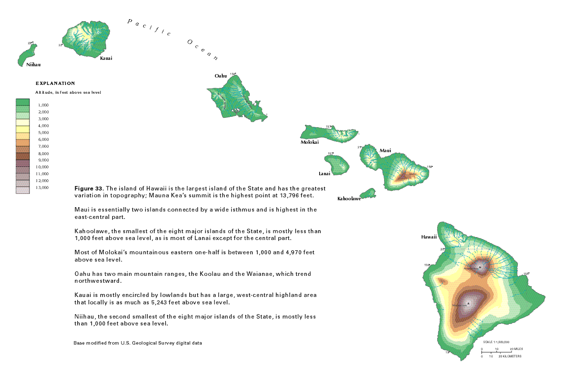
Topography of the Big Island, Hawaii, with elevations in feet. Mauna
Kea (north) and Mauna Loa (south) both exceed 13,000 ft elevation.
Map modified from USGS, "Ground Water Atlas of the United
States. Source.
Hawaiian volcanoes progress through 4 stages, starting with the preshield phase when volcanic activity begins. Stage 2 is the shield stage and is the most active period of volcanic activity when the vast majority of the volcano’s volume is created. Magma rises from the hotspot located as deep as 60-70 below the crust where it is stored in shallow reservoirs. During volcano growth, erupting lava emerges both from the summit of the volcano and from several lateral rift zones. The post-shield stage is next, and consists of additional volcanic activity for about 0.1 to 0.3 million years after the shield stage. Finally, after perhaps a quiescent period, there is the rejuvenated stage, a period of variable length where some additional volcanic activity may occur. The Big Island is the only Island in the shield stage. Landslides and erosion gradually wear down the volcanoes.

There are five volcanoes comprising the Big Island: Kohala, Mauna Kea, Hualalai, Mauna Loa, and Kilauea. Only the latter two have erupted recently. Kilauea is the most active volcano in the world. I hope to see lava flows when we visit the National Park in a few days. A bit to the southeast of the Big Island lies the submerged Loihi, which is the newest volcano in the long Hawaiian chain. Some thousands of years into the future, it may form its own island by breaking the ocean surface or it may merge with its neighbors to grow the size of the Big Island.

The five volcanoes of the Big Island. Map and key modified from Sherrod et al. (2007).


References

Clague DA, Dalrymple GB. 1987. The Hawaiian-Emperor Volcanic Chain. Part I. Geologic Evolution. USGS Professional Paper 1350.

Langenbeim VAM, Clague DA. 1987. The Hawaiian-Emperor Volcanic Chain. Part II. Stratigraphic Framework of Volcanic Rocks of the Hawaiian Islands. USGS Professional Paper 1350.

Sherrod DR. 2009. Hawaiian Islands, Geology. In: Encyclopedia of Islands, Gillespie RG and Clague DA (eds), University of California Press, Berkeley, CA, p.404-410.

Sherrod DR, Sinton JM, Watkins SE, Brunt KM. 2007. Geologic Map of the State of Hawai’i. USGS Open-File Report 2007-1089.