Showing posts with label glaciers. Show all posts

06 August 2017

John Muir Wilderness II

Sunday 30 July 2017.

Muriel Lake and Mt. Humphreys in the background.
Midday, North of Goethe Lake. Clouds 15%. MWS and I crossed over Piute Pass again in the morning after camping for the night near Piute Lake. Veering off the main trail a little towards the south, we followed a remnant of another trail but were soon off the marked path. We arrived at Muriel Lake, an irregularly shaped and scenic alpine lake, with glacial rubble and red-tinted snowfields in the vicinity. A few very small icebergs were floating in the water, calved from a shelf of snow abutting the western shore.

Rounding the northern point of Muriel Lake, we proceeded south, gaining some elevation and eventually obtained a grand view of Goethe Lake, an unnamed smaller companion lake, Mt. Goethe (13,270 ft), Muriel Peak (12,937 ft), and the Goethe Glacier. The glacier, which was the original intended destination, was set in a rocky enclave, about halfway in height between Goethe Lake and the top of the rugged mountain ridge to the south (to which the Muriel and Goethe peaks contributed). Beyond the ridge to the south is the wilderness of Kings Canyon National Park. Meanwhile to the north, the whole morning while hiking, tree-less Mt. Humphreys (13,992 ft) was visible, an impressive monument of sharp jagged brown rocks dressed on its side with a checkerboard of not-yet melted snow patches.
Goethe Lake (left) and Gothe Glacier (right photo at center).

Goethe Lake and its unnamed companion were stunningly beautiful, perhaps my favorite of the trip. At this season, both lakes were a mix of open water and floating ice. The unnamed lake had a brilliant patch of turquoise water towards the southern end and elsewhere the water of both lakes was a deep vibrant blue. The glacier was mostly white, and unexpectedly so to me, for I had anticipated being able to see bluish ice. In place of blue, it had some vertical streaks of dirty green that I assume are outcroppings of ice.

The whole Goethe landscape was ruled by granite and snow and beautiful lakes, sparse in life, but abundant in majesty and contrast. The afternoon of our hike, the air was warm with a cool breeze belying the assured harshness of the landscape in the dead of winter. There were still trees at our elevation (~12,000 ft), but they mostly took on a shrubby growth form. Mosses, grass, and flowers – all of short stature – were present too, but they must be subject to the realities of a short growing season.

A panorama of about 180 degrees, from Mt. Humphreys in the north to Goethe Lake and Goethe Glacier to the south.

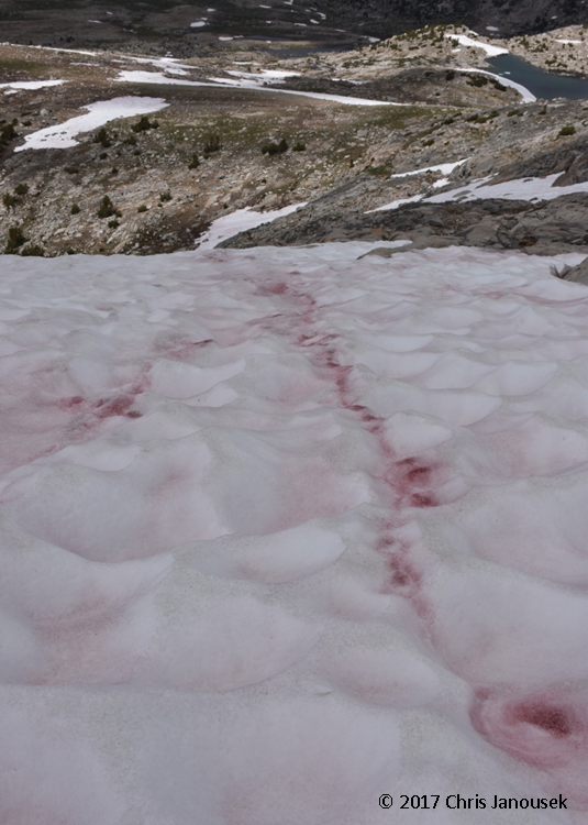
A prominent streak of snow algae near
Lake Muriel. 
The snowfields in the wilderness have presented really attractive patterns and colors to me. Many are tinted red or pink from algae living within the hardened snow. My friend recently provided an excellent overview of this “watermelon snow” in her blog here, and you can read more about the algae here. I’ll only repeat here the main fact underlying this phenomenon – namely, that the organism responsible for the unusual streaks of color is a green alga, Chlamydomonas, which produces brilliant carotenoids (orange, yellow, and reddish pigments responsible for the color of carrots and autumn leaves). In the John Muir Wilderness, the alga was present on many of the snowfields.

My other snow observation was the pattern of regular undulations in the surface of many of the snow fields, some craters exceeding a few feet. I’m unsure how these craters form, but they seem to arise from the melting process, not from the original deposition of snow. Most of the snowfields were very firm – approaching ice – and it was relatively easy to walk across them in hiking boots.

A fortuitous granite "tent" provided some
relief from the sun.


Early afternoon, NW of Goethe Lake. Clouds 25%. We climbed a bit higher to the top of a ridge (~12,080 ft) that separates the Goethe Basin to the east and the Wahoo Lakes basin to the west. Like Goethe Lake and its unnamed companion lake, the Wahoo Lakes have icy surfaces, not solid but broken up on the surface. I was worried about sun exposure, but found a little shade (a scarce resource in this nearly treeless alpine area) in a tent formed by two slabs of salt and pepper granite that learned against each other. The sun here is intense and the clouds are mostly to the east and north of our location, providing little relief.

We returned to the campsite in the afternoon. By late afternoon and early evening cloud cover increased to 75% as the afternoon progressed on the west side of the pass. The valley grew grey and soon thunder announced her presence. I remarked earlier in the day how I thought it would be great to have a Sierra thunderstorm, and here she was! A dozen or so lightning strikes clapped to the east and then rain and hail fell in a marvelous summer storm. The downpour was intense for a short time, sending a barrage of precipitation into Piute Lake. After no more than about an hour the storm passed, but the sun never fully returned to the valley for the day, leaving grey clouds, cool air, and wet ground for the evening. At sunset, a reddish haze appeared in the west; purple and red skies in the east.

A brief video of the storm:


Small icebergs at the edge of Muriel Lake.
USGS topographic map of part of the John Muir Wilderness (Mt. Darwin quadrangle, 2015), including some of the areas we explored on the second day of the backpacking trip (red dotted line).

19 July 2017

End of an (ice) age

Jackson Glacier at Glacier National Park.
Several National Parks, including Redwood, the Grand Canyon, and Glacier are named after their most iconic feature. They were established with an eye to the future to protect unique or superlative biological and geological features. In protecting a park’s namesake, whether that is old-growth redwoods or a pristine snowy peak, a whole ecosystem and its diverse components can also be protected from exploitation or excessive degradation. But at Glacier, the glaciers are disappearing.

A glacier is essentially a perennial slow-moving river of ice, formed from the long-term compaction of snow, flowing slowly down a mountainside. The weight of the glacier gradually propels it downslope, while its mass is renewed by new annual snowfall. Technically “official” glaciers have a minimum size of 25 acres. Glaciers are fantastic geologic agents: they carved out Puget Sound in Washington and the stunning Yosemite Valley in the Sierra Nevada for example.  

About a century and a half ago, there were estimated to be nearly 150 glaciers present in Glacier National Park. But by 2015, that number had declined to only 26. The trends at Glacier in northwest Montana track patterns elsewhere: glaciers are shrinking and snowpack is declining. Data from several benchmark glaciers in the northwestern US show mass loss of glacial ice over the last four decades. In the uneven distribution of climate change impacts across the globe, high latitude (particularly Arctic) and alpine regions appear to be warming to a greater degree than other regions.

Left: Map of some of the named glaciers in Glacier National Park and the adjacent Flathead National Forest. Right: Change in the area occupied by Chaney Glacier between 1966 and 2015. Map and figure from USGS.

Change in the Clements Glacier at Glacier NP.
Images from USGS Repeat Photography Gallery.

Glacial growth and retreat is a natural geologic cycle. Currently, the Earth is in an interglacial period, at the warm peak of an alternating cycle of cooling and warming that has alternated periodically over the last 2.6 million years. About 10,000 years ago the last major glacial period ended and the glaciers that covered much of the land in the northern hemisphere melted and retreated, sending sea-levels hundreds of feet higher.

So is the loss of glaciers today part of a normal cycle? Probably not, because today’s rate of atmospheric CO2 increase (due to human production of greenhouse gases) is unprecedented in recent geologic history. A global increase of 1 to 2°C that may have occurred over centuries or millennia in the past is now on our doorstep in a matter of decades. And because large-scale biological and geological processes can temporally lag the events that drive them, we have probably locked in additional warming for years even were we to cease all additional greenhouse gas emissions tomorrow.

The glaciers and snowfields of Glacier National Park provide the source waters for rivers that flow to the Pacific Ocean, the Gulf of Mexico, and Hudson Bay. The park straddles the continental divide, the cross-roads of the watersheds that collectively cover most of North America. Glacial melt is a particularly important source of water to mountain ecosystems in the late summer when the non-glacial snowfields have already melted.

Long-term change in snowpack throughout the western United States. Red circles indicate areas
 with snow decline. Image from EPA.


Change in the size of the Grinnell Glacier at Glacier NP.
Images from USGS Repeat Photography Gallery.
Driving through the park this month, I saw the lingering snowfields of the higher peaks, with perhaps a glacier or two tucked into the mountains. The melting water fed rapidly flowing streams, waterfalls, and lakes. The only glacier I definitively saw was Jackson Glacier from a viewpoint along the “Going-to-the-Sun” road. Views of other glaciers required more committed backcountry hikes that I didn’t have the time for on the trip.

By emitting so many greenhouse gases into the atmosphere in such a short time, we may be ushering in an era of unprecedented warming across the planet that may affect everything from species distributions to ocean acidification and sea-level rise. The threats to glaciers are a global phenomenon, requiring global action to address. More locally, at Glacier NP and other alpine ecosystems, it remains to be seen how the loss of glaciers will affect ecosystem processes over the coming centuries.   

References

Glacier National Park website

National Snow and Ice Data Center. 2017. All About Glaciers.

US Geological Survey. Retreat of Glaciers in Glacier National Park

US Geological Survey. Repeat Photography Gallery.


Snowfield and Bird Woman Falls as seen from the
"Going-to-the-Sun" road at Glacier National Park.

06 July 2017

Paradise

Mt. Rainier from the east.
The luminous peak of Mt. Rainier is omnipresent in central Washington, visible near Olympia, looming in the east from Seattle, and touching the western horizon from the edge of the desert of central Washington. At over 14,400 feet, it is the highest member of the Cascade Range and dwarfs the nearby mountains.

For my second visit to Mt. Rainier National Park, we camped for two nights at Ohanapecosh, a low elevation campsite in the southeast corner of the park. The afternoon we arrived we detoured to a short trail starting at the White River campsite on the road to Sunrise. A trail ascended from dense forest near the campsite and followed the frigid turbulent water of the White River. The Emmons Moraine Trial branched towards the south, crossing the White River with a narrow footbridge constructed of a single log. The water jumbled over boulders in such a rush that spray danced into the air. Across the river the trail continued upward along a ridge that overlooked the terminus of Emmons Glacier and its moraine. This valley to the south was barren higher up (perhaps old ground the glacier used to occupy), forested with short trees farther down, and adorned with a beautiful turquoise lake farther still. The lake wasn’t on any map I had seen of the park. I learned that Emmons Glacier is the largest glacier in the lower 48 states.

Left: Unnamed alpine lake near the White River. Right: White River and Emmons Glacier.

On the south slopes of Rainier lies Paradise, a popular stopping point and gateway to the snowy alpine. On the second morning I set out with my two oldest to wander up the slopes of Paradise looking for wildflowers. Most of the Skyline Trail area was still under snow. In street shoes, we were not well prepared, but we hiked on the firm snow anyway, gaining enough elevation to have excellent views of Mt. Saint Helens and Mt. Adams to the south.

Glacier (Nisqually Glacier I believe) on the
south slope of Mt. Rainier visible from Paradise.
When we started the hike most of the bright slopes of Rainier were still visible, framed by a deep blue sky. A few clouds tightly hugged the mountain near the summit, wisping off the east side of the peak. A large patch of grayish white clouds quickly moved in and obscured the top of the mountain. Nisqually Glacier, when it was visible, was a ribbon of ice streaming downslope from near the summit, cracked and shining aquamarine light in places.

Up to an elevation a little above the visitor’s center there were meadows of yellow alpine lilies (Erythronium grandiflorum) and white avalanche lilies (E. montanum), each species generally clustering together with its own. At somewhat higher elevations however, the main flowering species changed to Trollius laxus (American globeflower), paintbrushes, and pink-flowered alpine shrubs where snow was not covering the ground. Chipmunks scurried about; marmots foraged more casually, largely ignoring hikers crisscrossing the snow trying to follow some semblance of trails. Lines of backpackers with ice axes, helmets, and better footware streamed by us headed for the pure white drifts of snow and ice above.


References


Turner M, Gustafson P. 2006. Wildflowers of the Pacific Northwest. Timber Press, Portland, OR.

Cascade Range peaks visible from the southern slope of Mt. Rainier. Left: Mt. Adams. Right: Mt. Saint Helens.
Paradise mammals. Left: Marmot. Right: Chipmunk bounding across a snowfield.
Firs on the slopes at Paradise.
American globeflower. 

14 August 2016

Thornton Lakes, North Cascades National Park

The northern Cascades, looking south from the Thornton Lakes area.
2016 is the centennial year of the National Park Service, and with an annual pass in possession, I’m making some effort to visit parks wherever I can this year. Ideally, I’d have the luxury of a whole summer off to explore parks throughout the west, but such an extended vacation isn’t feasible.

I did have two weeks off to travel to the Pacific Northwest in July and the last wilderness stop I made was North Cascades National Park in northern Washington. It was a first time visit for me, as was Mt. Rainier in central Washington earlier that week. North Cascades encompasses two areas – a northern section of the park which extends to the Canadian border and a southern area bordered by two national forests and Lake Chelan National Recreation Area. Ross Lake National Recreation Area bisects the two park units, and is generally the gateway to the whole region. Almost all points of access to the National Park itself are by foot trail; in fact, there are only two dirt roads that lead anywhere directly into the park. Most of the park is also part of the Stephen Mather Wilderness.

The southern-most of the Thornton Lakes.
The terrain is rugged – forest, exposed rock at higher elevations, and many glaciers. The park has over 300 glaciers, a large fraction of all those found in the lower 48 states. Using aerial photography and measurements at several glaciers, researchers have been assessing their rates of change. Like other montane regions, the apparent effects of climate change are alarming: at North Cascades, total glacier area is estimated to have declined by about 40% since the mid 1800s.

I hiked into the park along the trail that leads to Thornton Lakes in the northern unit. The first 3 kilometers or so beyond the trailhead, there was little ascent as the trail went north and then south following the contour of a valley through mid-elevation forest. Thereafter it turned north again, but with significant elevation gain up the slope of the mountain. It was a challenging day hike, finally terminating on the eastern flank of a basin that held the southernmost of the lakes. From this relatively high vantage point, I could see the snow-capped peaks to the south, probably in the southern unit of the park.

The slopes of the lake basin were steep and a creek tumbled into the north end of the lake off in the distance. The trail down to the lake was likewise steep and I only went down partway, not reaching the lake. From the distance, however, I could see a constant stream of concentric ripples radiating out over the water’s surface. Perhaps fish were rising periodically to the surface to feed on insects.

Ripples on the lake.

One day hike of course was only a tiny sampling of this large and seemingly spectacular part of the Cascade Range. I look forward to another chance to hike or backpack into this rugged and remote wilderness.

References

National Park Service. Undated. North Cascades National Park map.

National Park Service, North Cascades National Park website.

07 August 2013

Green Lakes, Three Sisters Wilderness

Broken Top with the southern-most of
the Green Lakes in the foreground.
Last week we took the kids on their first backpacking trip to the Three Sisters Wilderness in the central Oregon Cascades. During the summer of 2012, I took two day trips to the northern side of the wilderness near the Mathieu lakes area, so this time we ventured into the eastern part, heading west from Bend.

The Green lakes trail starts near where Fall Creek empties into a broad alpine expanse that is part meadow and part lake. The trail tends to closely follow Fall Creek northward where it tumbles out of a valley. At the height of the summer the cold water was still moving briskly and there were a few waterfalls and rapids along the several miles between the trail head and the point where the creek emerges from the Green Lakes basin. Along the banks of the creek, there were myriad flowers and wetland plants including orange and pink paintbrushes and Delphiniums.

At about 6500 foot elevation, the valley opens northward into a large basin that is home to the three Green lakes. The basin is a beautiful jewel nestled in between two of the tallest peaks in the Oregon Cascades: South Sisters to the northwest (10,358 ft) and Broken Top to the east (9175 ft). From different points within the basin, Mt Bachelor (9068 ft) and one of the companion Sister peaks are also visible. Both South Sisters and Broken Top have small glaciers according my copy of a USFS map. However, while South Sisters had some lingering patches of snow, it was hard to consider these glaciers per se. A warming climate is threatening the persistence of glaciers worldwide, and I wonder if these smaller glaciers in the Pacific Northwest are particularly vulnerable to rapid demise.


Fall Creek
Our camp was located just some 100 m east of Fall Creek near the point where it begins to leave the basin and tumble down into the valley that we had ascended. In this area the creek was lined with willows growing as dense shrubs no more than 1-2 m high. We also found numerous black tadpoles in the shallow creek, with fat oval bodies and eel-like tails. The older kids had fun catching them.

Immediately west of the valley was an extensive lava field with little apparent vegetation. The field had dark boulders of shiny obsidian mixed with the milder colors of volcanism: light and medium greys and orange. We noted that many of the rocks of the lightest grey color were extremely light weight for their size; I found that one could easily snap the smaller ones in half.


Plants along the edge of Fall Creek. I don't
know this species, but the flowers had the
very distinct smell of watermelons!
The slopes of South Sisters itself had little vegetation, but were composed of some scattered snow patches, fields of grey volcanic rubble and a streak of reddish rock near the summit. Along much of the trail, the forest seemed to be composed mostly of mountain hemlock, though there were firs and pines present as well. I do not recall seeing a single broadleaved tree. Much of the remaining vegetation was low lying shrubs and herbaceous plants, particularly in the more open volcanic meadows around Green lakes. Despite the rugged landscape, many plant species were in bloom, giving the harsh terrain an elegant vibrancy.